
|
|
|
-- Helping Americans Make Their Voices Heard on Policy Issues -- Using Geographic Information Systems and Congressional Communities The U.S. 435 118th Congressional Districts (CDs, in session Jan 3, 2023 to Jan 3, 2025) have an average population of approximately 763,000 population, larger than three states. The size and diversity of CDs can make it difficult to communicate effectively with Congress. Congressional Communities, subdivisions of Congressional Districts, can help Americans better have their voice heard by Congress. Learn more about the Congressional Communities program and how you can participate. Examine Congressional Communities and Congressional District maps and characteristics .. use the VDA Congressional Communities/Congressional Districts resource interactively using only a Web browser .. in context with wide-ranging geography and subject matter for example K-12 schools, school districts, census tracts .. patterns of economic prosperity; demographic trends .. see these notes about using the direct access VDA CC/CD Two VDA GIS Congressional Communities Projects VDA GIS users (start VDA Web GIS) may select from two similar but different Congressional Communities projects. Select either of these projects using the Project Manager screen after login. • Congressional Communities - start-up view U.S. by 118th Congressional Disitrict - in the search box key in "CD CA 47" (no quotes) and press enter .. map refreshes with zoom-in to that CD - in the legend panel, optionally check-on the Cong Communities & Cong Communities Code .. map now shows the CCs in context of the CDs • Congressional Districts CA 47 - start-up view CA CD 47 area -- showing congressional communities in context of CA CD 47 - optionally "slide this view" (pan/drag) to area of interest; optionally save the revised view/project Congressional Communities, Mapping and Geographic Information Systems (GIS) Why would you want to use GIS with Congressional Communities and Congressional Districts? Maybe start with "a picture is worth a thousand words" ... our ability to absorb and interpret visual information can provide faster and is often easier than using tabular data alone. Visualization of geographic patterns can be more engaging than textual or spreadsheet presentations alone. Geospatial visualizations, maps, can provide a more effective basis for collaboration and understanding. Only GIS enables us to look at different geographies and subject matter, simultaneously, to understand patterns and make compelling arguments.
• 01 Using the Congressional Communities GIS Project • 02 Examining My Congressional District • 03 Examining Congressional Community residents at risk from toxic substances • 04 Congressional Communities "GIS Project" purpose, structure, content .. join in the every Thursday web session for demos. Q&A, problem solving. Congressional Communities and the GIS Infrastructure Using Congressional Community (CC) geography involves more than opening a CC shapefile with a GIS tool/software. Or, opening a CC shapefile with a 118th Congressional District (CD) shapefile with a GIS tool/software. To gain insights about CCs and collaborate on CC topics involves/requires an additional 10-15 shapefiles with other geography and subject matter. For example, it is important to be able to create pattern and reference maps depicting how census tracts intersect with CCs. This infrastructure is developed by organizing these shapefiles into a GIS project. This section is focused on one primary Congressional Communities GIS Project, though many variations might be developed. 1. Using the Congressional Communities GIS Project .. goto top This section is focused on using the Congressional Communities (CC) project with the VDA Web GIS. The CC GIS project was developed using CV XE GIS and ported to the server for VDA Web GIS use; nothing required to use it but a web broweer. The same CC GIS project can be used with CV XE GIS and VDA Desktop GIS for use in a desktop environment. 1.1. Getting Started • Learn more generally about GIS • Learn about VDA Web GIS • Learn about Getting Started with VDA Web GIS - where that narrative suggests using MetroDynamics project, use the Congressional Communities project • Start VDA with any browser any device. -- https://vdagis.com - desktop or laptop recommended. - login .. the VDA interface displays - close the browser to end a session. • The start-up view of the GIS project is shown below. Click graphic for larger view.  • Viewing different geography and subject matter. .. do these steps on your computer after the map interface view starts. Patterns of economic prosperity by census tract .. click the checkbox on the Tracts $MHI layer in the legend panel at left of map. .. the following map view shows these patterns. 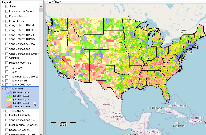 Patterns of %majority-minority by congressional community .. uncheck the checkbox on the Tracts $MHI layer in the legend panel. .. click the checkbox on the Cong Communities %Maj-Min layer in the legend panel. .. the following map view shows these patterns. 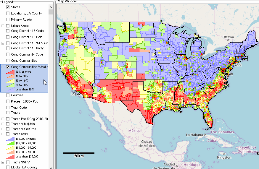 • Some basics of navigation - the "active layer" is set using the upper left dropdown. .. for the CC project the "active layer" is the Congressional Community layer. - the legend panel is located at left of map window. .. the legend panel shows all available layers in this project. .. the legend panel includes the layers reviewed in Section 2 above. .. click a checkbox on in the legend panel to make the layer visible in the map window. .. click the + by the layer name to show the layer intervals/sections. - to zoom in/out use +/- buttons below map window. .. or click in map window and drag to lower right to zoom in. - to drag the map view hold Shift key down and drag mouse. • Find your Congressional Community (CC) based on an address. - enter an address in the Find Address edit box. - click the Find Address button. -- the map window zooms to that location and displays a blue marker. .. the associated CC displays with cross-hatch pattern. .. the lower left panel displays attributes for this CC. - click the HTML button below the lower left panel to view as HTML page. .. the content of this HTML page is reviewed elsewhere. .. optionally CTRL-A on HTML page, CTRL-C to copy, open Excel, CTRL_V paste. .. now optionally examine CC(s) using Excel.
An Example. Locate an address in CC 0634002 (used in section 2 below).
Enter the address "717 N Bonnie Beach Pl, Los Angeles CA 90063" (no quotes) in the Find Address edit box and click
the Find Addresa button. The map view zooms to this location and places a blue triangle on the map. Click the triangle,
the CC shows cfross-hatched and a CC profile shows in lower left panel.
• Get/View a CC-CD comparative analysis profile. - continuing from above click Tools>Profiles>CC Profile. - this operation displays a comparative analysis profile: comparing the CC to the CC. .. the content of the profile is reviewed elsewhere.
An Example. Click here to view the illustrative profile for CC 0634002.
This profile compares the CC to its corresponding CD for selected attributes based on data from Ceneus 2020. .. the profile shows CC 0634002 comprises 58,675 population of the total CD 757,694 population (7.74%) .. what about other attributes? .. in documenting a request to a congressperson, a resident could note "our CC comprises 7.74% of this CD. 1.2. Using the Table Feature The Table feature provides spreadsheet-like access to attributes of the "active layer" and more. • click the Table/Query toggle button below the map window at right to view the table. - in the case of the CC project with default active layer this will show all CCs - each row is a CC with attribute items arrayed across the table as columns. - the header row shows the layer field/item name. - operations on the table do not permanently affect stored data. • How to View CCs for a Congressional District. - what CCs comprise a CD? where are they? how do they relate? .. CD CA 34 is used as an example, used in application at top of this page. - place a query on the table .. enter "geoid like '0634%' (no quotes) in the SQL Filter edit box. .. click query button at the right .. the table refreshes; see at left below that there are 16 CCs in this district. .. the CCs in CD CA 34 are listed in the table. - show CCs in CA 34 in the map .. click the button below the table "highlight all that meet query" .. the map view zooms and shows these CCs. 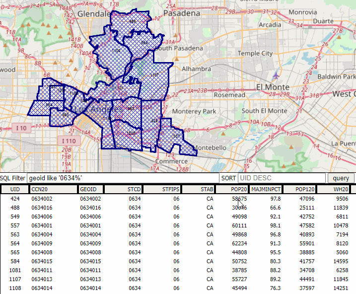 .. click graphic for larger view. • How to Rank CCs and show selected items. .. continuing from the previous operation ... - what subject matter items are available for the "active layer" (CCs)? - click "Select Field" button below table. .. a list of available subject matter items appear. .. this answers the question "what items are available in this layer? - click CCN20 and POP20 checkboxes; then "Set & Close" .. the table refreshes with only these columns showing. - to rank these CCs based on POP20, key in "POP20 DESC" in the sort edit box above the table. .. click Query button; table refreshes showing CCs sorted on POP20. .. if necessary, drag column divider for better view of item values. - where is the top-ranked CC? .. click the top row; it turns blue. .. click the button "click geography row to display" below the table. .. the map view zooms to that CC. 1.3. More Advanced Applications Tracts in Los Angeles County with Median Household Income $200,000 .. click graphic for larger view .. where are they and what are their codes? .. this graphic shows the tract codes in the table below the map window. .. tracts are located in the table and shown/highlighted in the map window.  .. how to develop a similar view? See these steps. .. the pointer is at tract 06037400205 .. see profile for tract 06037400205 (xls) 2. Examining My Congressional District .. in East Los Angeles .. illustrative application Examine characteristics of any Congressional District by Congressional Community using this GIS tool/project/data as shown in graphics below. Click graphic for larger view. Zoom-in View of California Congressional District 34 .. lay of the land view, CD CA 34 bold boundary, yellow labels, with CCs shown with black boundaries, white labels. .. zoom to the area and click checkboxes on for layers: Cong District 118 Code, Cong District 118 Bold, Cong Community Code and Cong Communities. 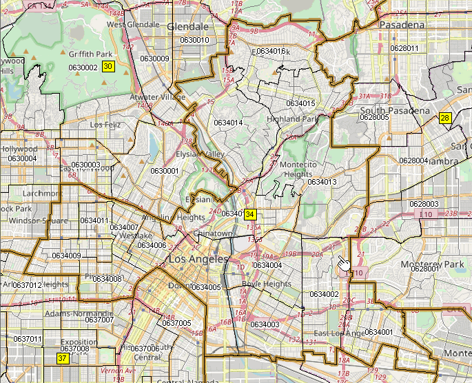 Patterns of Economic Prosperity in California Congressional District 34 .. similar to the above view, the following graphic shows patterns of median household income based on American Community Survey 2021 by census tract. View developed by checking the checkbox on the "Tracts $MHI" layer in the legend panel. Using this GIS tool/project/data it is easy to see how and where different CCs and tracts in the district vary by economic prosperity. 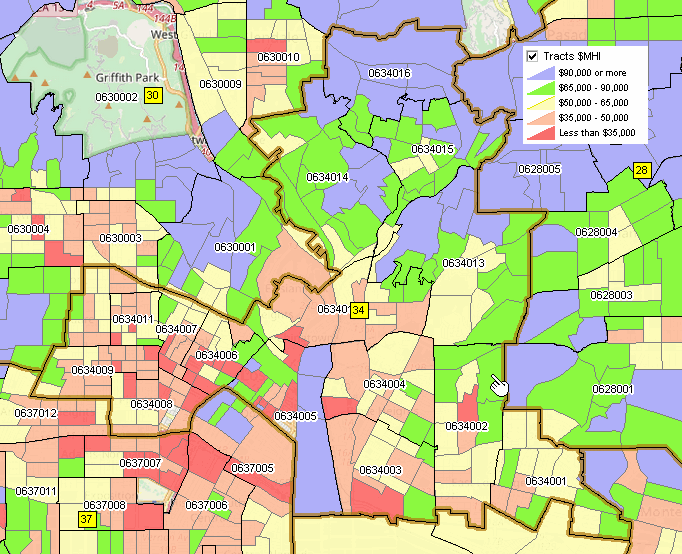 3. A Call to Action in Congressional Community 0634002 .. in East Los Angeles .. illustrative application .. collaborate with stakeholders in your Congressional Community .. share your collective voice with Congress .. Congressional leadership .. learn more about CC constituent areas .. just one example. As reviewed in the Los Angeles Times residents are at risk from toxic substances in the East LA area that includes Congressional Community (CC) 0634002, part of Congressional District CA 34. Note, the CC code 0634002 refers to FIPS state 06, 118th CA CD 34, specific CC in that CD 002. The map below, developed using the Congressional Communities Geographic Information Systems (GIS) project, shows the location (see pointer) of a census tract highlighted in the story. That tract is contained in CC 0634002 and CD CA 34. See more about GIS. The clean up area is also shown in this graphic Tract 06037530603 in Context of CC 0634002 .. click graphic for larger view CCs shown with red bold boundaries labeled with CC code; census tracts shown with black boundaries. 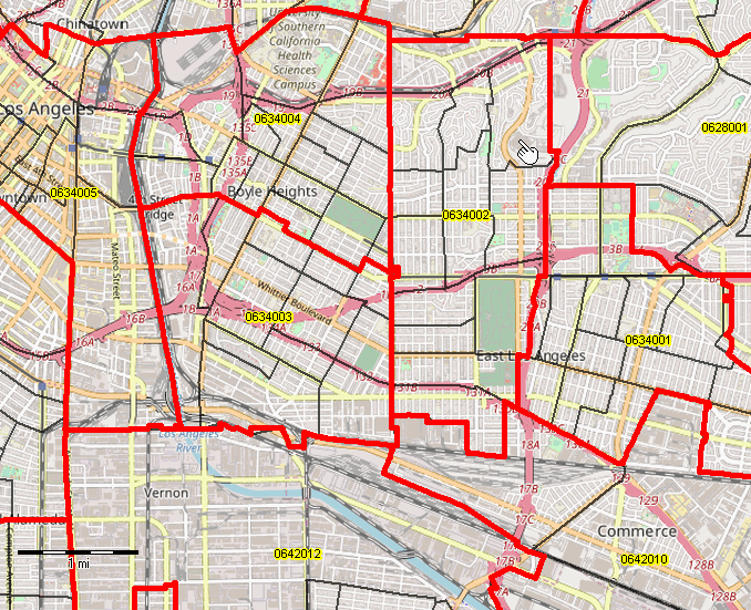 Knowing more about Tract 06037530603 and CC 0634002 .. click graphic for larger view Tract $MHI clicked on, showing patterns of economic properity by median houehold income by tract. 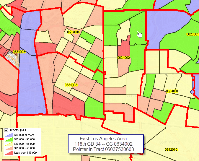 4. Congressional Communities GIS Project .. Structure and Orientation .. goto top A national scope Congressional Communities GIS Project has been developed that you can use with VDA Web GIS using only a Web browser .. use with any device (desktop/laptop recommended) .. nothing to install. The same GIS project can be used with the desktop GIS software CV XE GIS and VDA Desktop GIS. This GIS project is a starting place, though a robust one. Many GIS project variations can be developed to meet a particular need. Structure of the Congressional Communities GIS Project .. goto top Layers in the Congressional Communities GIS Project The following layers are shown in the legend panel to the left of the map window. 1 States 2 Locations, LA County .. residential locations used for illustrative purposes. .. show similar point or location data for your areas. 3 Primary Roads .. national scope primary roads 4 Urban Areas .. national scope 2020 urban areas 5 Cong District 118 Code .. national scope 118th congressional districts .. these layers contain these subject matter items (xls) .. use this layer to show CD codes 6 Cong District 118 Bold .. use this layer to show CDs with bold boundary 7 Cong District 118 %HS Grad .. use this layer to show CDs with %Highs School Graduates ACS21 8 Cong District 118 Party .. use this layer to show CDs by party of incumbent 9 Congressional Communities Code .. national scope congressional communities .. these layers contain these subject matter items (xls) .. use this layer to show CC codes 10 Congressional Communities .. use this layer to show CC boundaries 11 Cong Communities %Maj-Min .. use this layer to show patterns of %majority-minority population 12 Counties .. national scope counties 13 Places, 5,000+ Pop .. national scope cities/places 14 Tract Code .. national scope census tracts .. use this layer to show tract codes .. tract layers (except Tracts Pop %Chg 2010-20) contain these subject matter items (xls) 15 Tracts .. use this layer to show tract boundaries 16 Tracts Pop %Chg 2010-20 .. use this layer to show how tract population changed from 2010 to 2020 17 Tracts %Maj-Min .. illustrative patterns of %majority-minority population by tract 18 Tracts %CollGrad+ .. use this layer to show patterns of %college graduates by tract 19 Tracts $MHI .. use this layer to show patterns of median household income by tract 20 Tracts $MHV .. use this layer to show patterns of median housing value by tract The following layers are provided for drill-down applications. .. most CC applications will be at the county or subcounty area. 21 Blocks, LA County .. Census 2020 census blocks 22 Cong Communities, CA .. Congressional communities, California subset 23 Block Groups, LA County .. Census 2020 census blockgroups 24 Roads, LA County .. Intersect to intersection roads 2022 TIGER edges 25 Neighborhoods, LA City .. LA Times city neighborhoods 26 Neighborhoods, LA County .. LA Times county neighborhoods 27 Parcels, LA County .. LA County Tax Parcels 28 County .. national scope county layer for use as a base layer 29 ZIP Codes .. Census 2020 ZIP Code tabulation areas 30 BaseLayer1 .. Open Street Maps topology 31 States1 .. for use as a base layer Most of the above layers contain subject matter items that can be displayed/mapped and otherwise examined. About VDA GIS .. goto top VDA Web GIS is a decision-making information resource designed to help stakeholders create and apply insight. Use VDA Web GIS with only a Web browser; nothing to install; GIS experience not required. VDA Web GIS has been developed and is maintained by Warren Glimpse, ProximityOne (Alexandria, VA) and Takashi Hamilton, Tsukasa Consulting (Osaka, Japan). Support Using these Resources .. goto top Learn more about accessing and using demographic-economic data and related analytical tools. Join us in a Data Analytics Lab session. There is no fee for these one-hour Web sessions. Each informal session is focused on a specific topic. The open structure also provides for Q&A and discussion of application issues of interest to participants. |
|
|
