
|
|
|
-- Demographic Characteristics & Trends December 2023 .. the latest official 2022 resident population estimate (May 2023) for the approximate 19,500 U.S. cities was 208.8 million. Of these cities, approximately 13,500 are in metropolitan areas (CBSAs). Small town America, 11,896 cities/towns are under 2,000 population in 2022 as can be determined using the interactive table below. Of the largest ten cities in 2022, all lost population except Phoenix and San Antonio. See about the related 2022 resident population estimates for counties in the CountyTrends section. Cities with 100,000 Population or More in 2022 The following graphic shows cities as markers with 2022 population of 100,000 or more. Click graphic for larger view (shows city names); expand window to full screen. 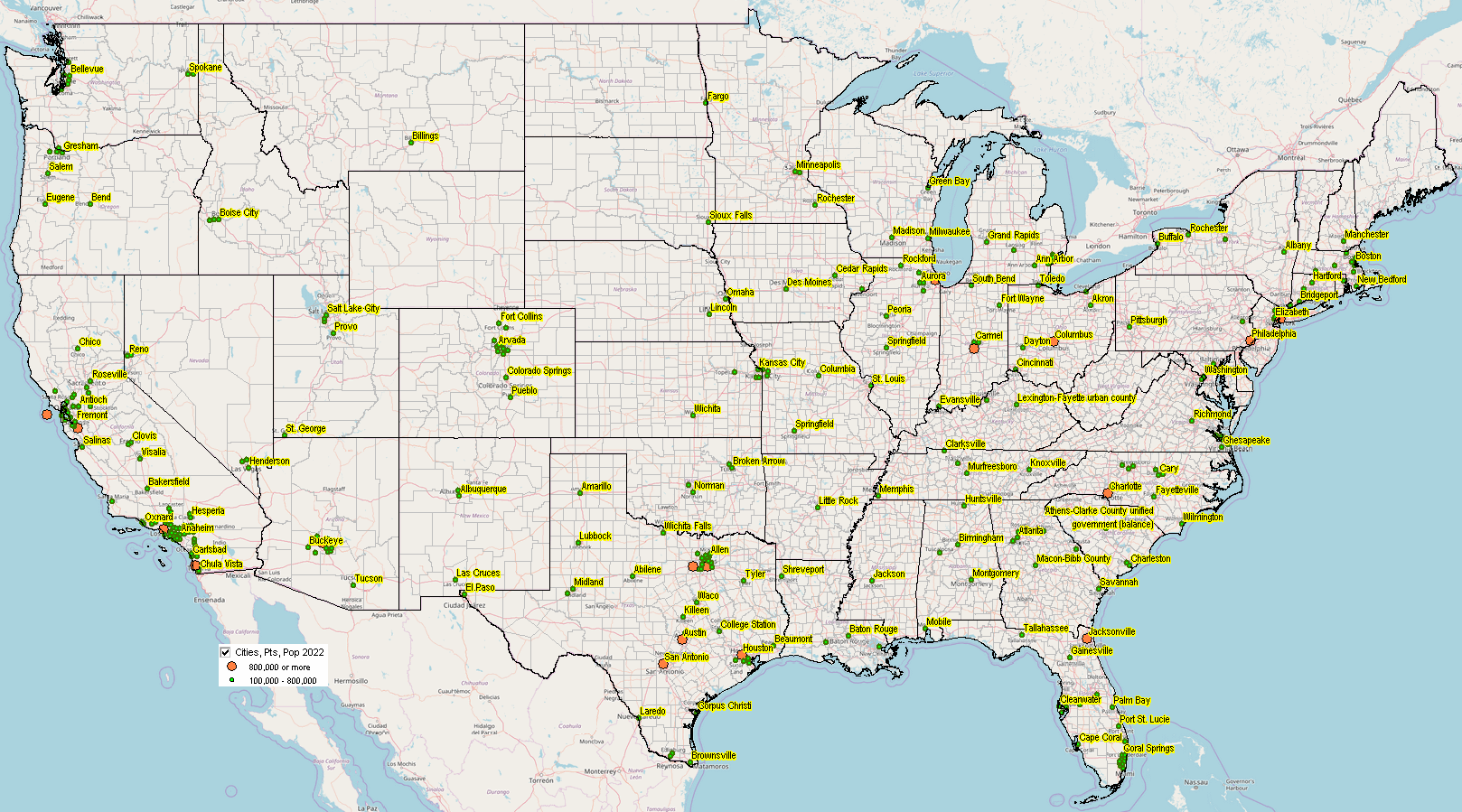 - use VDA Web GIS to interact with map view. Cities Gaining/Losing Population 2020-2022 The following graphic shows cities as markers with 1,000 or more population. .. the largest 10 metros based on total population are shown with bold boundary. .. green markers are cities gaining population; orange markers are cities losing population. .. click graphic for larger view; much better marker view; expand window to full screen for best quality view. 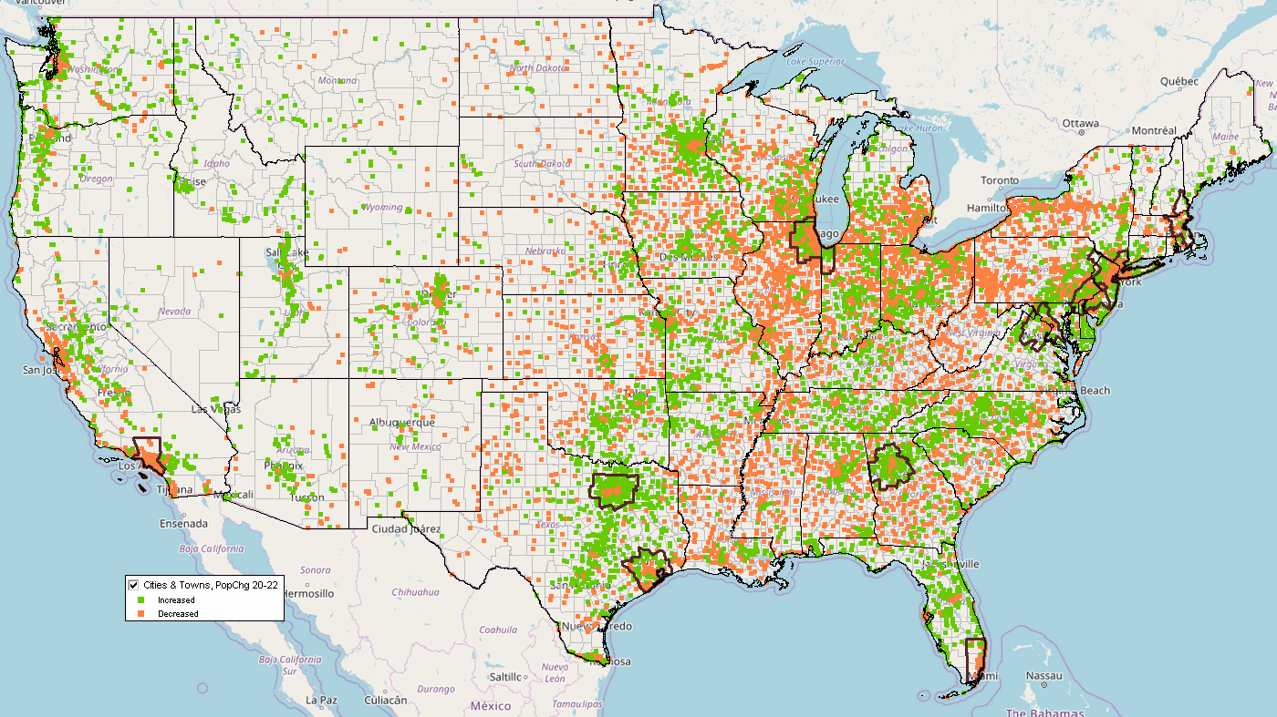 - use VDA Web GIS to interact with map view. City Demographic Trends & Characteristics 2020-2022 Interactive Table .. goto top Rank on any column by clicking column header; use mouse-over on column header to view description of item. Use horizontal bar, slide right, to view more columns. .. use buttons below table for selective columns view. Usage Notes • Click ShowAll between queries/filters. • Use left-most column to select by state. • Find in Name button; click ShowAll button first .. click Find in Name button to search column 1 for text in edit box. .. text entered in edit box is case sensitive. .. partial names are okay to use. .. click with default value to view all rows with "Houston" (no quotes) • Find in CBSA button; click ShowAll button first .. click Find in CBSA button to search column 6 for text in edit box. .. text entered in edit box must be the 5-character CBSA code. .. click with default value to view all rows with "26420" (no quotes) ... 26420 is the Houston, TX metro CBSA code .. enter the CBSA code for a metro of interest see list of codes. • Find in County button; click ShowAll button first .. click FindCounty button to search column 5 for text in edit box. .. text entered in edit box must be the 5-character state+county FIPS code. .. click with default value to view all rows with "48201" (no quotes) ... 48201 is the Harris County, TX state+county FIPS code .. enter the state+county FIPS code for county of interest see list of codes. Selected columns buttons • Population Min & Max> button .. click to show only peer group counties based on values in min and max edit boxes. .. enter the minimum 2022 population in the left edit box. .. enter the maximum 2022 population in the right edit box. • Click ShowAll between queries/filters. Using the U.S. by Cities Shapefile with Integrated Demographics .. goto top The U.S. by city/place shapefile is developed/updated annually as part of the Census Bureau TIGER/Line digital map database. It is the most authoritative and up-to-date source of annually updated incorporated city boundaries. ProximityOne integrates the city population annual time series estimates into the smoothed version of the national U.S. by place shapefile. About These Data -- goto top City and sub-county population estimates are developed annually by the Census Bureau. The model-based estimates are normally released in May (e.g., 7/1/22 estimates released in May 2023). Population estimates are for incorporated cities with boundaries as defined as of January 1, 2022. Incorporated Cities/Places The legal designations, powers, and functions of incorporated places vary from state to state. Incorporated places include cities, towns (except in New England, New York, and Wisconsin where towns are county administrative subdivision), boroughs (except in Alaska where boroughs are treated as equivalents of counties and New York where five boroughs comprise New York City) and villages. Incorporated places can cross county boundaries. ProximityOne assigns each city to a county and CBSA/metro (if located in a CBSA). The county is assigned using a U.S. by city point shapefile. The county is assigned to a city for the county that contains the city point (internal area latitude-longitude). The CBSA code is assigned based on the county code (all CBSAs are comprised of one of more counties). Data in Excel/Database Structure Data shown in the table are available in the form of Excel, CSV or DBF structure. Users of the shapefile (described above may use the dbf part of the shapefile for tabular/spread-type analysis and to integrate with other data. Subject Matter Items in Table -- goto top
- City Name
- St - GEOID - Type - Land Area SqMi - Water Area SqMi - County Name - State County Code - CSA Code - CBSA Metro Code - Metro Div Code - Population 2020 - Population 2021 - Population 2022 - Population 2020-22 Change - Population 2020-22 %Change Geographic items based on 2022 TIGER/line data. Other items based on Census 7/1/22 vintage model-based estimates released May 2023 (included in above table). Support Using these Resources .. goto top Learn more about demographic economic data and related analytical tools. Join us in a Data Analytics Lab session. There is no fee for these Web sessions. Each informal session is focused on a specific topic. The open structure also provides for Q&A and discussion of application issues of interest to participants. ProximityOne User Group .. goto top Join the ProximityOne User Group to keep up-to-date with new developments relating to geographic-demographic-economic decision-making information resources. Receive updates and access to tools and resources available only to members. Use this form to join the User Group. Additional Information .. goto top ProximityOne develops geographic-demographic-economic data and analytical tools and helps organizations knit together and use diverse data in a decision-making and analytical framework. We develop custom demographic/economic estimates and projections, develop geographic and geocoded address files, and assist with impact and geospatial analyses. Wide-ranging organizations use our software, data and methodologies to analyze their own data integrated with other data. Follow ProximityOne on Twitter at www.twitter.com/proximityone. Contact ProximityOne (888-364-7656) with questions about data covered in this section or to discuss custom estimates, projections or analyses for your areas of interest. |
|
|