
|
|
|
.. Census Tract ACS Data Profiles: Demographic, Social, Economic, Housing .. use with Visual Data Analytics (VDA) Geographic Information Systems (GIS) The primary purpose of using the Census Tract project is to provide mapping and related support for the demographic-economic estimates. For example, development of a view of 2023 America Community Survey percent high school graduates or median household income. Use the data contained in the Demographic, Social, Economic, Housing layers described in detail by the metadata files. Understanding Census Tracts vs ZIP Codes It is important to distinguish between Census Tracts and ZIP Code Tabulation Areas (ZCTAs). These geographies, both defined once every ten years, often compete for the analysis of small area, more reliable data. Census Tracts • Polygon areas developed by the U.S. Census Bureau for data collection and tabulation. • Cover the U.S. wall-to-wall, nesting within county geography. • Building block geography, and demographics, for other Census geography: county, metro, PUMA, state. • Considered more statistically reliable than ZCTAs. • Developed with a known average of 4,000 population at the time of census. • Developed once per decade. • Often dual-sided (each side of a street may belong to a different area). • Approximately 85,197 tracts, more than twice as many ZCTAs. • Used more widely than ZCTAs by other Federal agencies. ZIP Code Tabulation Areas • Polygon areas developed by the U.S. Census Bureau for data tabulation. • Emulate ZIP Codes, based on respondent data. • Not all areas have mail delivery; ZCTAs do not cover the entire U.S. • Data for ZCTAs are tabulated from the Census, ACS, and other programs. • Wide ranging population size; potentially 60,000 persons in one ZCTA. • Developed once per decade. • Approximately 33,171 ZCTAs, compared to about 44,000 ZIP Codes. • ZCTAs do not include P.O. Boxes or FPO military codes; accounting for difference. Using the Census Tracts VDA GIS Project To find a Census Tract: 1. Enter an address in the iVDA interactive mapping search bar and press Enter. 2. The map view will relocate to the corresponding Census Tract. Use the Census Tract American Community Survey Data Profiles (TRACTS_DP) GIS project using iVDA or VDA4. The start-up view of the TRACTS_DP GIS project using iVDA is shown below. Using iVDA with Tract ACS DP Project .. goto top .. The starting view shows the lower 48 states by county. .. the page being viewed is located at https://proximityone.com/tracts_dp.htm Metadata Metadata files describe the fields in corresponding layers, with illustrative sample views (click graphic for larger view). .. each graphic shows view of item from that layer. ACS Demographic XLS -- 94 statistical items percent Hispanic by census tract 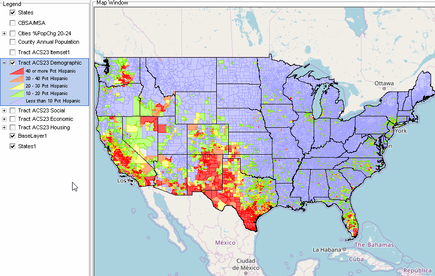 ACS Social XLS -- 154 statistical items percent College Graduates by census tract 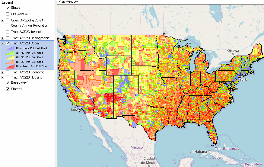 ACS Economic XLS -- 137 statistical items Median Household Income by census tract 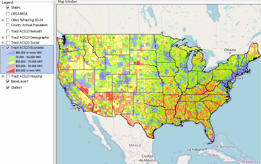 ACS Housing XLS -- 143 statistical items Median Housing Value by census tract 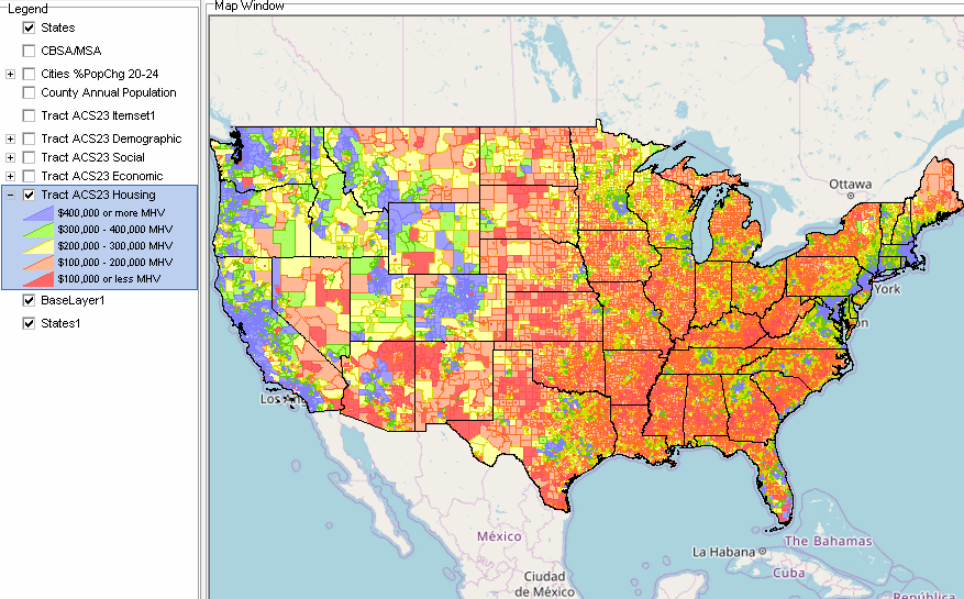 The Census Tract VDA GIS Project -- a "Group One" GIS Project .. goto top There are several Group One VDA GIS projects further described in the VDA4 GIS project Main Menu section. Group One Projects have these properties: .. focused on one geography. .. comprised of approximately 10 layers. .. contain the identical, most recent data for these layers: States CBSA/MSA Counties Cities States1 Base layer -- topology Role of GIS and Analysis of Census Tracts A Geographic Information System (GIS) is a computer -based tool that allows users to store, analyze, visualize, and interpret geographic data. Geographic data, also known as spatial or geospatial data, identifies the location of features on earth. GIS combines the visual elements of maps with the ability to link characteristics about those features in datasets. This relationship allows GIS to locate, display, analyze, and model data. GIS technology integrates geographic data with statistical and administrative data using statistical methods and analytics. These abilities make GIS valuable to a wide range of public and private enterprises for explaining events, predicting outcomes and planning strategies. And collaborating on those issues. About iVDA & VDAGIS .. goto top iVDA is an HTML iframe embedded version of VDA Web GIS. VDAGIS tools and data have been developed and are updated/supported by Warren Glimpse/ProximityOne/Alexandria, VA USA and Takashi Hamilton/Tsukasa/Osaka, Japan. Support Using these Resources .. goto top Learn more about census tract demographic economic data and related analytical tools. Join us in a Data Analytics Lab session. There is no fee for these informal sessions focused on your interests. The open structure provides for Q&A and discussion of application issues of interest to participants. Terms of Use .. goto top There is no warranty regarding any aspect of this using this project. The user is solely responsible for any use made of iVDA or data contained in project files. Contact ProximityOne (888-364-7656) with questions about data covered in this section or to discuss custom estimates, projections or analyses for your areas of interest. |
|
|