
|
|
|
The Citizen Voting Age Population (CVAP) is a measure of the total population who are both U.S. citizens and 18 years or older. It is tabulated annually as part of the American Community Survey (ACS) for geographic areas ranging from the United States to the lowest level block group. CVAP is crucial as it indicates the maximum potential number of registered voters in an area. The ratio of CVAP to the actual number of registered voters shows how many eligible citizens are not registered to vote. For areas where the ratio exceeds one (>1.00), voting rolls may need updating. Use the VDAGIS interactive mapping tool below to find CVAP data for specific census tracts and compare it with other demographic information. Patterns of Percent CVAP Population by State The graphic below shows the percentage of the Citizen Voting Age Population (%CVAP) by state from the ACS 2022 1-year estimates. State %CVAP ranges from 66.4% in Texas to 81.1% in Vermont, with the U.S. average at 72.4%. Click the map for a larger view. 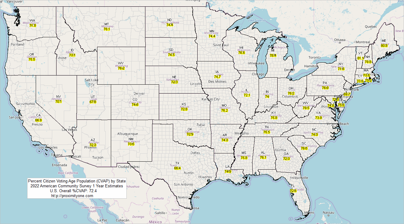 Interactive Mapping -- Using VDAGIS to Examine CVAP by Census Tract 1. Watch the Video: Click here to see a video that explains the steps below. 2. Start-Up View: The initial view shows the U.S. 48 states by county. 3. Objective: Examine the percent CVAP by census tract. 4. Search Location: - Enter "15625 SW 80th St, Miami, FL 33193" in the search bar above the map. - Click the "Find Location" button. The map will zoom to this address. 5. Navigate the Map: - Use the buttons below the map to navigate. - To zoom, hold down left+shift and drag the mouse to draw a box. 6. Enable Layers: - In the legend panel on the left, scroll down and check "Tracts Code". - Scroll further down and check "Tracts %CVAP". - Click the + next to the layer name to expand the color/value intervals. 7. View %CVAP Patterns: The map now displays %CVAP by census tract in the selected area. 8. Get Tract Details: - Click any census tract to highlight it and display its profile in the lower left. - For example, click tract 12086017800 (at the marker) to see: - Population: 6,063 (D001TPOP — for those who know Census tables) - CVAP: 3,119 9. Calculate %CVAP: The %CVAP for this tract is (3119 / 6063) * 100 = 51.4%. Interactive Mapping with Data Access Static Graphic Showing Application View The graphic below shows the address location (blue triangle marker) in context of tracts by CVAP color pattern and Congressional Communities (CC .. labeled with CC code: 1228007). This tract is contained within this CC and Congressional District FL 28. 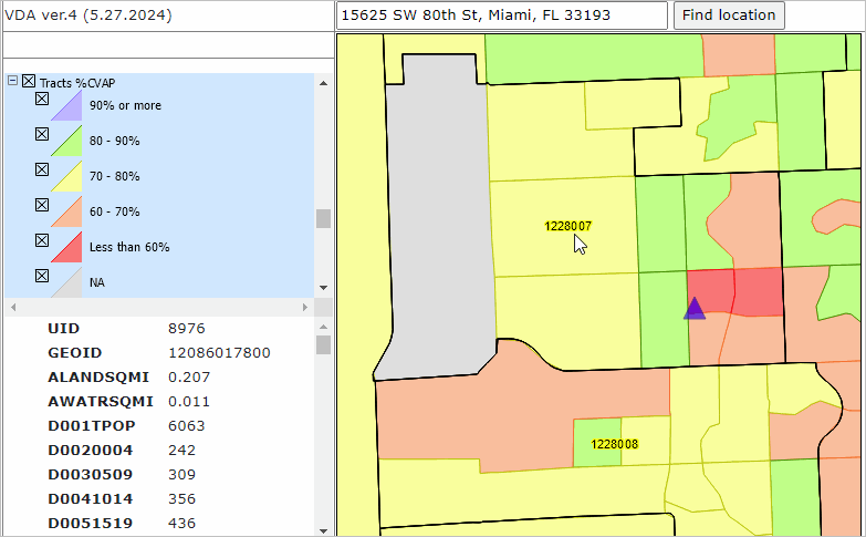 ProximityOne User Group Join the ProximityOne User Group to keep up-to-date with new developments relating to metros and component geography decision-making information resources. Receive updates and access to tools and resources available only to members. Use this form to join the User Group. Support Using these Resources Learn more about accessing and using demographic-economic data and related analytical tools. Join us in a Data Analytics Lab session. There is no fee for these one-hour Web sessions. Each informal session is focused on a specific topic. The open structure also provides for Q&A and discussion of application issues of interest to participants. Additional Information ProximityOne develops geographic-demographic-economic data and analytical tools and helps organizations knit together and use diverse data in a decision-making and analytical framework. We develop custom demographic/economic estimates and projections, develop geographic and geocoded address files, and assist with impact and geospatial analyses. Wide-ranging organizations use our tools (software, data, methodologies) to analyze their own data integrated with other data. Follow ProximityOne on Twitter at www.twitter.com/proximityone. Contact ProximityOne (888-364-7656) with questions about data covered in this section or to discuss custom estimates, projections or analyses for your areas of interest. |
|
|