
|
|
|
zoom to two blockgroups Registered Voters as Markers 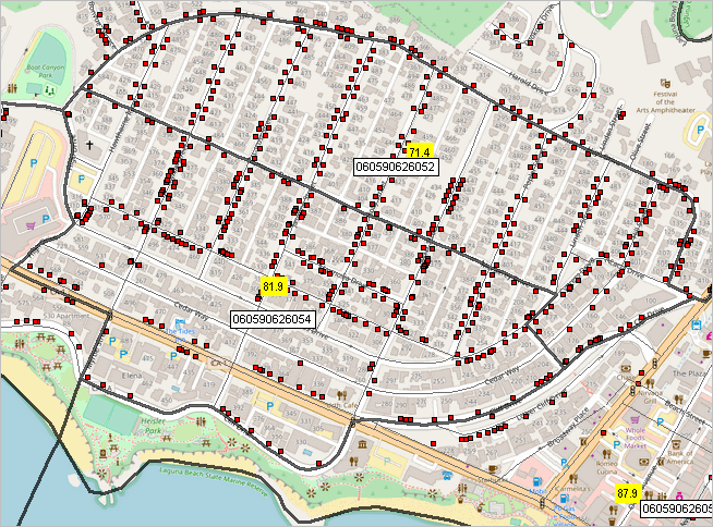
see more below 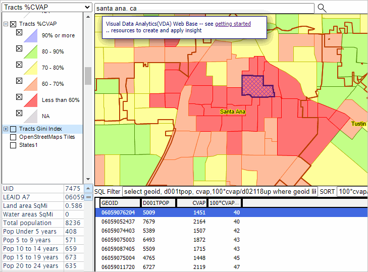
-- Registered Voter & Citizen Voting Age Population -- block group data analytics January 2024. Voter turnout for the 2022 U.S. congressional elections was the second highest for a nonpresidential election year since 2000, with 52.2% of the citizen voting age population participating. Voter registration rates were the highest for a midterm election since 2000, with 69.1% of the citizen voting age population registered to vote, up 2.2 percentage points from 66.9% in 2018. These data are based Current Population Survey (CPS). See more about the CPS 2022 November data below. For the 2022 election, the data show that 31.8% of all voters cast ballots by mail, up from 23.1% in 2018. 47.1% voted before Election Day, up from 37.8% in 2018. What about the future? Examining Registered Voter & Citizen Voting Age Population for Small Areas By examining the relationship between registered voters (RV) and citizen voting age population (CVAP) for small area geography, it is possible to determine where gaps might exist between these two populations. With this information, data, about these gaps, it might be possible to better target areas for increased voter registration, ultimately increasing the vote and voter participation. This section reviews the process and results of these analyses for Orange County, CA. An objective is to compare the CVAP and RV summary data by/for each block group across the county. There are 239,780 Census 2020 block groups covering the U.S. wall-to-wall. See more about the scope of related geodemographic data. See more about Voting and Voter Registration Data on a national scale. Voter Registrants in Context of Block Groups; Orange County, CA The graphic below shows block groups with black boundaries and registered voters as markers. Density of markers and scale renders markers to be indistinguishable. See about accessing/using GIS tools below. Click for graphic larger view. 
Congressional Communities .. goto top An objective is to associate these block group (BG) data with Congressional Communities (CCs). Congressional community participants can use these data and related tools to examine voter participation in their area of interest. See more about Congressional Communities. Join in today; extend your network. Process Overview .. goto top In the initial steps, 1.81 million OC registered voters were geocoded, assigning a latitude-longitude and geocode to each matched address using the Census Bureau batch geocoder. We plan to improve the match rate and accuracy as this program is exanded. There were 1.77 million matched. Of these, 1.61 million were exact matches. The 1.77 million were used in the subsequent data development. The block group (BG) geocode was used because the ACS 2022 citizen voting age population (CVAP) is tabulated/estimated for the BG and higher level geography. The BG is used as the focus geographic unit. Separately, a set of selected ACS 2022 5-year demographic items were extracted into a file using the DEDE tool. These items included the CVAP. These items were then integrated into the Census 2020 TL BG shapefile. Next, the address data were aggregated, computing the RV count by BG. The resulting RV count by BG data item were merged into the BG shapefile dbf. That shapefile was added the a GIS project separately developed. VDAGIS OCVOTE Project & Database .. goto top Using that GIS project, the maps shown above, below were developed. This next graphic shows a zoom-in to the Laguna Beach area showing BGs with black boundaries. Each BG shows three labels. The top label is the percent RV to CVAP, middle RV, lower CVAP. In concept the percent should also be below 100. RV should always be less that CVAP. As you can see, this is not the way it turned out. Among the reasons for this are: Laguna Beach, CA BG 0605906060502 with Registered Voters as Markers .. goto top 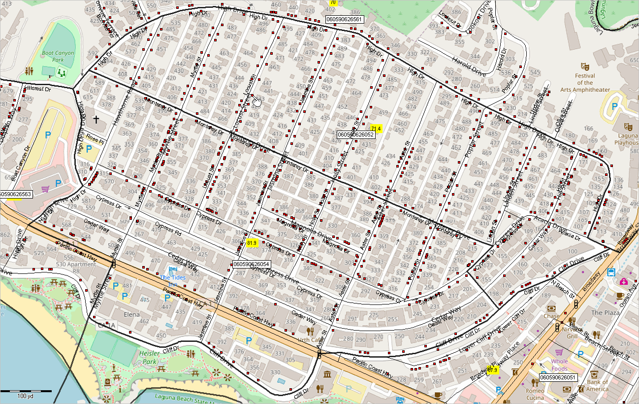
Congressional Communities and CVAP/BG Analytics .. goto top The next graphic shows a zoom-in to the Laguna Beach area, focused on CC 0647001 (bold black boundary). Registered voters are shown as red markers. Block groups are shown with black boundaries. The pointer is near the two block groups shown in the above graphic. 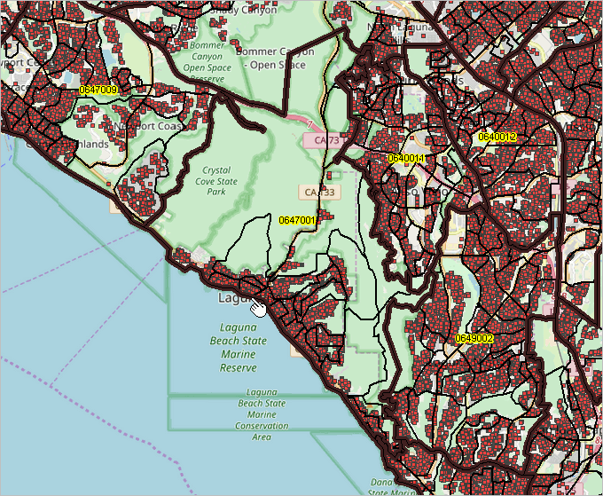
Examining Voting Demographics using VDAGIS .. goto top Geographic Information Syatems (about GIS) enable the user to dynamically, flexibly creat views such as those presented above. Those map graphics have been developed using VDAGIS tools. Authorized users can access the ready-to-use OCVOTE GIS project with only a browser and Internet. You can use the VDAGIS tools to examine voter and related demographics for anywhere in the U.S. Use the Open VDA Web GIS .. see more about OVDAW The following application provides an example focused on the Santa Ana, CA area. All you need is a browser and Internet (mobile devises not recommended due to screen size). No registration or login required. Nothing to install. Proceed with these steps: 1. Click to start OVDAW 2. Key "Santa Ana, CA" (no quotes; any address also works, or latitude,longitude) into search bar and press Enter .. the map refreshes with a zoom to that locatiion and shows the location with a blue marker. 3. In the upper left dropdown select the layer "Tracts %CVAP" 4. In the legend panel at left, check on these layers: .. Cities Label .. Cities .. Tracts %CVAP 5. Add Table/Grid view: click circle-A button at right below map window 6. Add Query settings: Query : select geoid, d001tpop, cvap,100*cvap/d02118up where geoid like '06059%' and 100*cvap/d02118up>=40 Sort: 100*cvap/d02118up desc Click query button; view should appear similar to view below. CVAP Patterns by Tract; Santa Ana, CA Area .. goto top The graphic below is a screen capture of OVDAW showing a zoom-in to the Santa Ana, CA area. The map graphic shows a thematic pattern of %CVAP by census tract. Cities are shown with red-brown boundaries and labeled with name. Colors shown in the map correspond to the legend shown at left of the map window. The user has clicked an artibrary tract; it highlights and profile is shown at lower left in graphic.
Scope of GeoDemographic Data .. goto top Data in this section are focused on data from the American Community Survey (ACS 2022), Current Population Survey (CPS) and administrative data records. No polling or election data are included as focus topics. Citizen Voting Age Population .. goto top CVAP data in this section are statistical data, sourced from ACS 2022 5-year estimates, centric to 2020 and for the respondent period 2018 through 2022. .. CVAP data have estimation and other statistical survey related errors .. based on our experience in using ACS BG data, they are very reliable, but take these factors into account Registered Voter Population .. goto top RV data are administratively collected and subject to a range of possible reasons for in accuracy .. the RV data are the “current vintage” and reflect the believed number of RVs. .. it is likely that many of the RV records are for people no longer at that address. - yielding a non-uniform and unknowable overcount Some known error was introduced into development of the RV summary data .. in general this should have led to a small undercount (addresses not matched). Join us ... Related Sections .. goto top • Congressional District GeoDemographics • Congressional Communities & Congressional District GeoDemographics • CPS, November 2022 Voting Supplement File CPS Voting Supplement Custom Estimates .. goto top The Current Population Survey microdata files may be used to develop custom demographic estimates for geography described below. Each record in the file, unit of observation, corresponds to an individual within a housing unit. Universe The universe consists of all persons in the civilian noninstitutional population of the United States living in households. The probability sample selected to represent the universe consists of approximately 50,000 households. Subject-Matter Data are provided on labor force activity for the week prior to the survey. Comprehensive data are available on the employment status, occupation, and industry of persons 15 years old and over. Also shown are personal characteristics such as age, sex, race, marital status, veteran status, household relationship, educational background, and Hispanic origin. The voting and registration questions were asked of all persons who were both U.S. citizens and 18 years or older, as applicable. Voting and registration data are collected every 2 years to monitor trends in the voting and nonvoting behavior of U.S. citizens in terms of their different demographic and economic characteristics. The November CPS supplement is a major source of information regarding national voting and registration. Geographic Coverage States, regions, and divisions are identified in their entirety. Within confidentiality restrictions, indicators are provided for 260 selected core-based statistical areas (CBSA), 42 selected combined statistical areas (CSA), 277 counties, and 97 principal cities in multi-principal city core-based statistical areas or combined statistical areas. Also, within confidentiality restrictions, indicators are provided for metropolitan/non-metropolitan, central city/balance metropolitan, and CBSA size. Support Using these Resources .. goto top Learn more about accessing and using demographic-economic data and related analytical tools. Join us in a Data Analytics Lab session. There is no fee for these one-hour Web sessions. Each informal session is focused on a specific topic. The open structure also provides for Q&A and discussion of application issues of interest to participants. ProximityOne User Group .. goto top Join the ProximityOne User Group to keep up-to-date with new developments relating to geographic-demographic-economic decision-making information resources. Receive updates and access to tools and resources available only to members. Use this form to join the User Group. Additional Information ProximityOne develops geographic-demographic-economic data and analytical tools and helps organizations knit together and use diverse data in a decision-making and analytical framework. We develop custom demographic/economic estimates and projections, develop geographic and geocoded address files, and assist with impact and geospatial analyses. Wide-ranging organizations use our tools (software, data, methodologies) to analyze their own data integrated with other data. Follow ProximityOne on Twitter at www.twitter.com/proximityone. Contact ProximityOne (888-364-7656) with questions about data covered in this section or to discuss custom estimates, projections or analyses for your areas of interest. |
|
|