|
|
|
.. examining the School District Community July 2024 .. did you know? the Clark County School District, NV is the 5th largest school district in the United States .. with a total resident population of 2,265,926. This is the most recent estimate and based on the American Community Survey ACS 2022 providing estimates for all approximate 14,000 school districts. Largest 10 School Districts
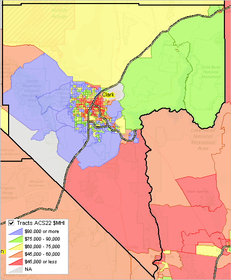
This section provides illustrative applications focused on geographic-demographic-economic patterns and characteristics for Clark County, NV and the Clark County School District, NV (CCSD) .. home to Las Vegas, NV. ProximityOne develops and applies tools and data resources to examine/analyze geographic-demographic-economic data to faciliate development and use of decision-making information for wide-ranging political and statistical geography. One of these is focused on the school district community, for any school district in the U.S. The content of this section is for illustrative purposes and has been developed using public data and has no formal relation with CCSD. See terms of use. The 2020 total resident population of Clark County School District, NV was 2,265,461 compared to 331,449,281 in United States. .. that the diversity index in 2020 was 72.0% for Clark County School District, NV compared to 61.1% for U.S. .. .. that the dependency ratio in 2020 was 61.19 for Clark County School District, NV compared to 63.64 for U.S. Learn more about how Clark County School District, NV compares the the U.S. CCSD & Visual Data Analytics Web GIS -- see related CCSD VDAGIS Discovery section usage details iVDA is presented below in an interactive mapping window .. watch video The start-up view shows a drill-down into the demographic-economic core of Clark County, NV. .. patterns of economic prosperity (median household income) by census tract. .. an overlay of Nevada State Senate districts Discussion Topics • School District Community • School Absenteeism NYT 3/29/24 Story • Census/ACS School District Tabulation - Grade Relevant Children Not Enrolled (RCNE) • Annual Census/SAIPE School District Population & Poverty Estimates -- Title I allocation formula component • School District Finances: Sources & Uses of Funds; Census/NCES Annual F-33 Survey - Funding Opportunities for Districts/Schools • Custom estimates/analyses using PUMAs/PUMS • Examining/redistricting School Attendance Zones; demographic projections by SAZ Section Topics • 01 Clark County Demographic Comparative Analysis Profiles • 02 Clark County GIS Project • 03 Using the Demographic Economic Data Explorer; building custom datasets • 04 Clark County Regional Economy 01. Clark County Demographic Comparative Analysis Comparing demographic attributes of Clark County, NV to the United States. These reports were developed using the ProximityOne Demographic Analytics tool. • Narrative Report • Tabular Report 02. Clark County GIS Project .. goto top The Clark County GIS Project is presented more "at the top of the topics" as it knits together selected key data and geography reviewed elsewhere in this document. This GIS project does not include any personally identifiable information. Adding data on students and staff would greatly enhance the utility of these data/tools for authorized users. The start up view of the Clark County Geographic Information System (GIS) Project using the VDAGIS tools is shown below. This view shows patterns of economic prosperity (ACS2022 median household income) by census tract. Click graphic for larger view that also shows Public Use Microdata (PUMA) boundaries. 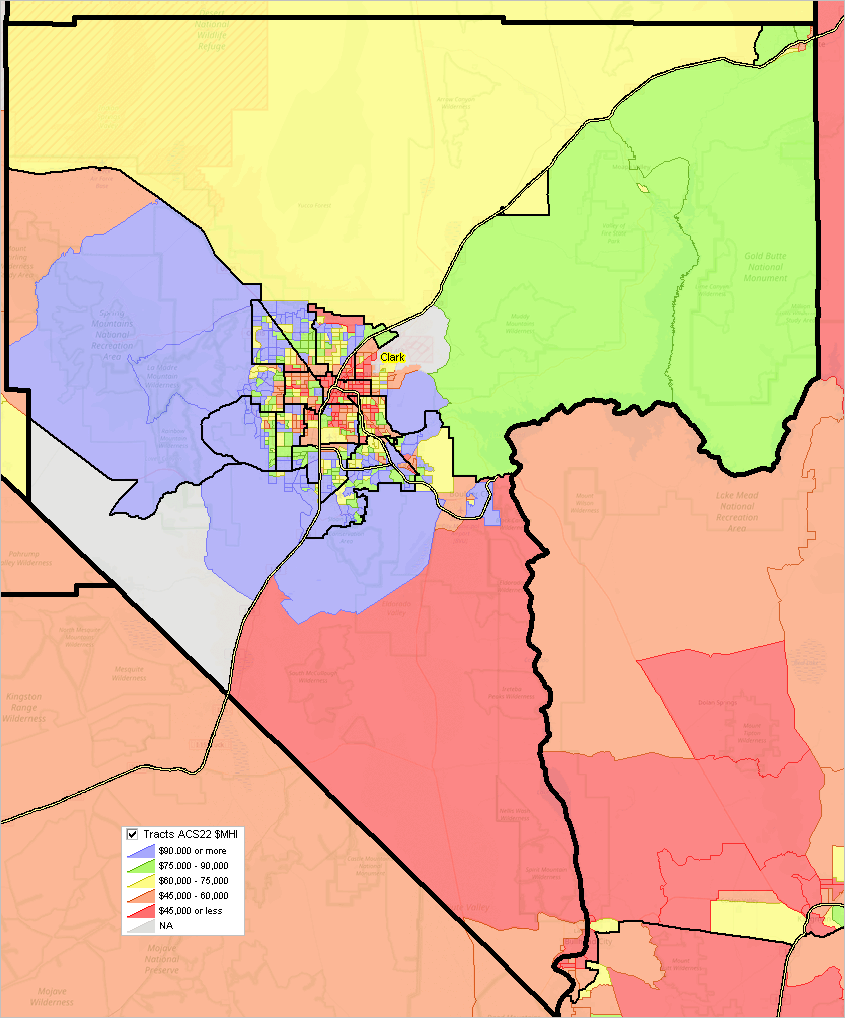
02.1. Clark County Public Use Microdata Areas (PUMAs) .. goto top PUMAs (click above graphics) are important as they provide the geography for which custom demographic estimates can be developed using Public Use Microdata Sample (PUMS) data. Develop custom demographic estimates for subject matter not included in the published ACS data. Suppose you want to estimate the number of teachers filtered by selected type of demographic attribute. Do that for PUMAs based on the sample of population data in the PUMS files. 02.2. Zoom-in View - Ed W. Clark School Attendance Zone & Related Layers .. goto top The following graphic is a zoom-in view of the Clark School Attendance Zone (SAZ) -- bold blue boundary .. Clark High School shown with blue marker at pointer. .. same thematic pattern view of $MHI by census tract as above. .. showing all K-12 schools in area .. see legend for school-marker type. .. showing intersection-to-intersection roads/streets (TIGER 2023). .. identify tool used to click on Clark H.S. and show profile to right of map. Click graphic for larger view 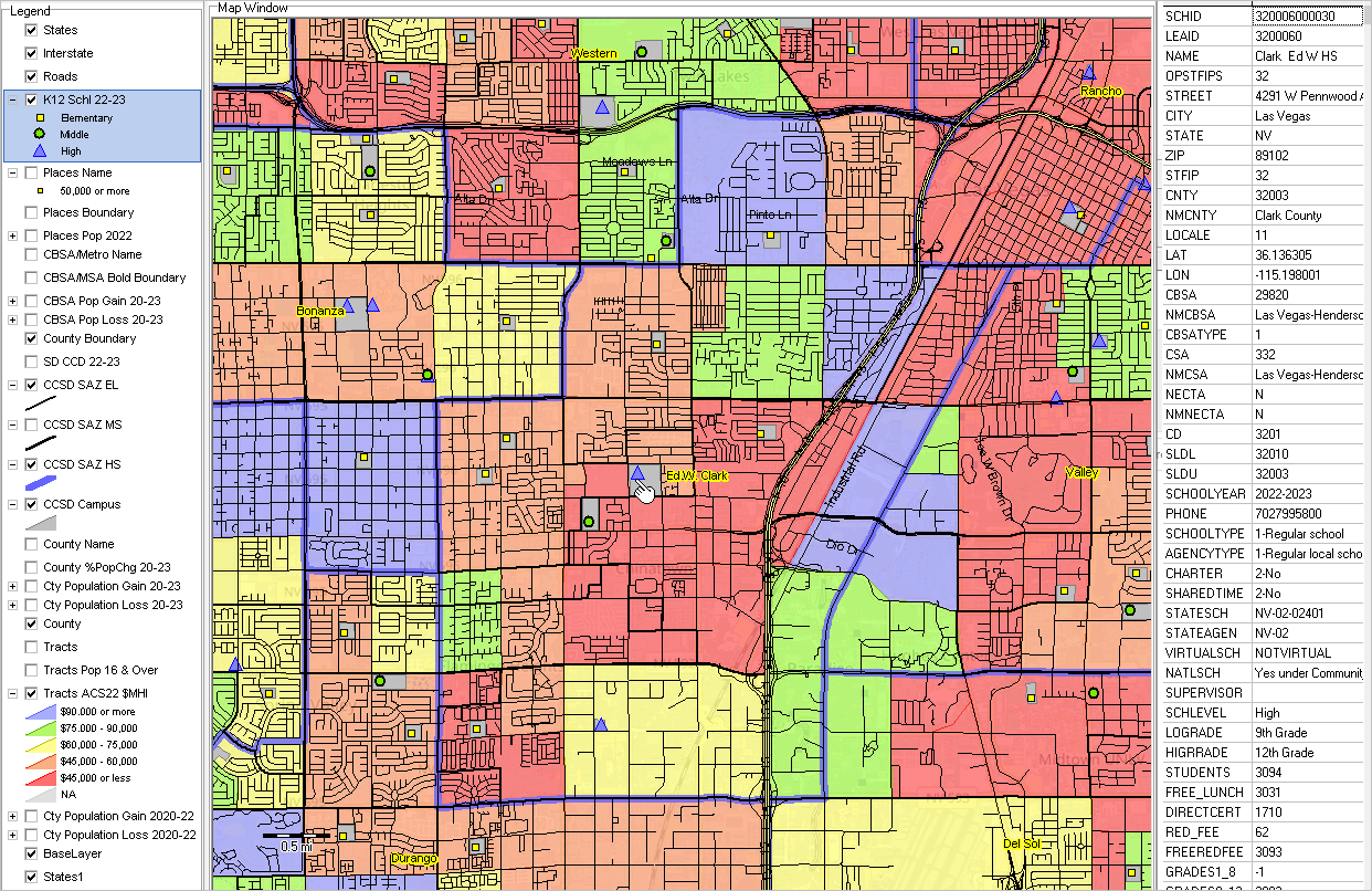
02.3. Tract Demographics developed using the Demographic-Economic Data Explorer .. goto top The following graphic shows a further zoom-in of the above graphic with some detail removed. The tract code as a label and $MHI as a label are shown by tract .. the $MHI is $45,115. This graphic illustrates use of the ProximityOne DEDE tool to “get one” to independently access $MHI for that tract; the same, by pointer, $45,115. DEDE, the Demographic Economic Explorer is generally used to develop Excel and GIS files using APIs, accessing larger databases. Click graphic for larger view 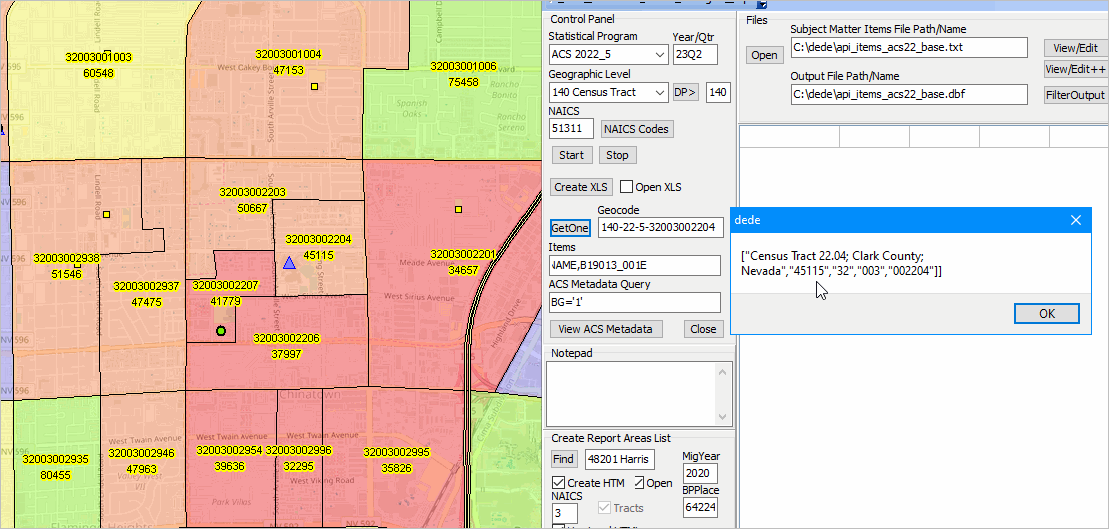
03. Using the Demographic Economic Data Explorer .. goto top The ProximityOne Demographic-Economic Data Exploere (DEDE) was used to develop the ACS 2022 census tracts dataset used in the Clark County GIS project "Tracts ACS22 $MHI" dataset. That file, xls or dbf, can be used in any application. In this case it was integrated into the tracts shapefile. That shapefile was then added to the GIS project. $MHI is only one data item shown in the map. A more extensive set of these data can be examined using the tracts interactive table. DEDE may be used to select subject matter data for many geographies from many Federal statistical programs. 04. Clark County Regional Economy .. goto top Examining the Clark County regional economy over tims. Developed using the ProximityOne Regional Economic Information System. • Clark County, NV The Clark County School District (CCSD) enrollment changed from 330,225 in the 2018-19 school year to 315,787 in the 2021-22 school year, a change of -14,438 (-4.4%). For the 2021-22 school year, CCSD ranked 5th largest among all school districts based on total enrollment. Examine 100 largest school districts in this interactive table. Clark County, NV Situation & Outlook (S&O) Report .. S&O reports are generated dynamics using the Demographic-Economic Data Explorer (DEDE) .. S&O reports are based on mainly Federal statistical data resources .. updating coninuously on irregular time periods .. View a recent Clark County S&O report - see detailed social characteristics, for example Clark County, NV Industry Profiles DEDE is also used to create custom data extracts from major Federal statistical programs. DEDE can also be used to create current or longitudinal industry profiles Examples for Clark County (click link to view): .. NAICS 713210 - Casinos (except Casino Hotels) -- 2022Q2 .. NAICS 721120 - Casino Hotels -- 2022Q2 Clark County, NV K-12 Schools 2021-2022 SY Interactive Table Click column header to sort; click again to sort other direction. Click ShowAll between queries. See related Interactive Tables Using the Interactive Table GIS & GeoSpatial Analysis Resources The remainder of this section provides illustrative view/map graphics for Clark County. These applications make use of GIS (Geographic Information System) tools and GIS projects that combine geographic (spatial) data (shapefiles) with statistical data. DEDE is often the source of the data integrated into shapefiles for reference and thematic/pattern map development. The two main Visual Data Analytics (VDA) software tools are: • VDA Desktop GIS (aka CV XE GIS) .. windows-based software • VDA Web GIS .. access/use with web browser only; nothing to install VDA tools are developed, maintained and supported by Warren Glimpse/ProximityOne/Alexandria, VA USA and Takashi Hamilton/Tsukasa/Osaka, Japan. Finding a Census Tract/Block Group Code Based on an Address .. goto top Find a census tract code and view the census tract boundary using VDA Web GIS. The following application illustrates how to find/view the census tract/block group code for the CCSD Liberty High School: Start VDA Web GIS .. more aboutVDA Web GIS On the next for, select the MetroDynamics project; map view opens Key in the address in the Find Address edit box above the map window, use 3700 Liberty Heights Ave, Henderson, NV 89052 Click Find Address button; the map views zooms to that location and places a blue triangle marker at the location. Click the blue marker .. the block group containing the marker highlights. .. a profile for this block group (BG) appears in the lower left panel profile. .. as shown in the graphic below, the BG code is 320030028531 (12 characters). .. the census tract code is the first 11 characters 32003002853 (11 characters) .. perform this operation for any address in the U.S. 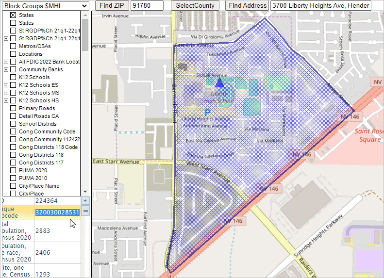 Terms of Use .. goto top There is no warranty with regard to any aspect of the content of this Web page. The user is solely responsible for any use made of content of this Web page. Support Using these Resources .. goto top Learn more about accessing and using demographic-economic data and related analytical tools. Join us in a Data Analytics Web session. There is no fee for these one-hour Web sessions. Each informal session is focused on a specific topic. The open structure also provides for Q&A and discussion of application issues of interest to participants. |
|
|