
|
|
|
-- 2,487 statistical areas covering the U.S. (50 states & D.C.) -- developing and using custom demographic estimates -- expanding insights through data analytics October 2024 .. .. this section is about the 2020 Public Use Microdata Areas (PUMAs) .. what they are, why they are important and how they can be used. The 2,487 2020 PUMAa are geographic areas generally with a minimum population of 100,000 and comprised of a set of contiguous 2020 census tracts covering the U.S. wall-to-wall. PUMAs are a statistical geography defined by the Census Bureau. The "2020 PUMA geography" are static tabulation areas for the period 2022 through 2031. American Community Survey 1-year estimates are tabulated annually starting with the ACS 2022 program year. PUMAs are important for many reasons: • their static geography during the 2020s lend this geography for use in time series analysis. • they are comprised of nested census tracts, providing analytical value. attributes of census tracts can be aggregated to PUMAs. • they are a good drill-down geography for larger counties. for example, Los Angeles County is compsrised or 72 2020 PUMAs. • PUMAs provide the geography for which custom estimates can be developed using PUMS files. • their geographic definition uses local area participation; making PUMAs relevant to regional analysis. • ACS 1-year annual estimates provide time series demographics with less than a 1-year lag. • they are the geographically smallest tabulation areas covering the U.S. wall-to-wall for which annual demographics are available. In this section: • Interactive PUMA Mapping & Geospatial Analysis • 2020 PUMA 2022 & 2023 Demographics Interactive Table • Using 2020 PUMAs with ACS Public Use Microdata Samples Patterns of Percent Population Change by PUMA 2022-2023 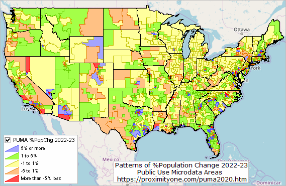
PUMA Mapping & GeoSpatial Analysis .. goto top .. the iVDA interactive mapping frame is shown below; with a start-up view of the U.S. lower 47 states. .. follow these steps to view PUMAs in an area of interest. .. enter a location or address in searchbar and press enter .. try Orange County, CA .. in the legend panel at left, click on "PUMA2020 Code" .. in the legend panel at left, click on "PUMA2020" .. the map window now shows 2020 PUMAs in the Orange County, CA region. .. click on any PUMA .. a demographic profile for that PUMA shows in the lower left panel. .. see more about iVDA .. show/examine schools .. click the checkbox on the "K-12 Schools Elem" layer in legend panel at left of map. .. show/examine attributes of a school .. click a school marker in map; profile shows in lower left panel. Using iVDA with Table/Grid & Mapping all Selected .. goto top The static map graphic below illustrates use of iVDA Table/Grid feature, selecting all PUMA2020 in Orange County, CA, then clicking Map All Selected to show in map window. The query shows 20 2020 PUNAs selected, shown in the Table/Grid panel. 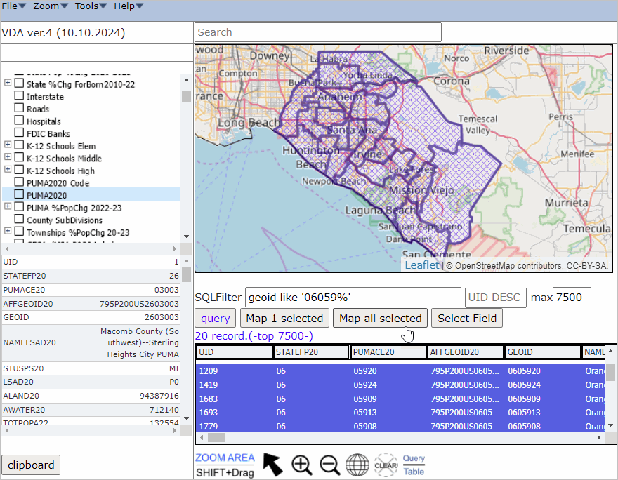
ACS 2022 & 2023 1-Year Demographics by PUMA 2020 -- interactive table .. goto top There is one row for each PUMA 2020. Click column header to sort; click again to sort other direction. Subject matter based on ACS 2022 1-year estimates & ACS 2023 1-year estimates Table Notes and Usage Operations: • Click ShowAll button between queries. Columns: - PUMA Name - St - GeoID - Population 2022 - Population 2023 - Population 22-23 Chg - Population 22-23 %Chg - Med Hsld Income 2022 - Med Hsld Income 2023 - Med Hsld Income 22-23 Chg - Med Hsld Income 22-23 %Chg -- 2022 -- - B01001_002E MPopA22 Male - B01001_026E FPopA22 Female - B02001_002E White1A22 White alone - B02001_003E Black1A22 Black or African American alone - B02001_004E AIAN1A22 American Indian and Alaska Native alone - B02001_005E Asian1A22 Asian alone - B02001_006E NHOPI1A22 Native Hawaiian and Other Pacific Islander alone - B02001_007E Other1A22 Some other race alone - B02001_008E MultiA22 Two or more races - B03002_012E HispA22 Hispanic (any race) - B01001_003E A0004MA22 Male: Under 5 years - B01001_004E A0509MA22 Male: 5 to 9 years - B01001_005E A1014MA22 Male: 10 to 14 years - B01001_006E A1517MA22 Male: 15 to 17 years - B01001_027E A0004FA22 Female: Under 5 years - B01001_028E A0509FA22 Female: 5 to 9 years - B01001_029E A1014FA22 Female: 10 to 14 years - B01001_030E A1517FA22 Female: 15 to 17 years - B09020_001E Pop65upA22 Population 65 years and over - B11002_001E PopHHA22 Population in Households - B11001_001E HHA22 Total Households - B11001_002E FamA22 Family Households - B15002_001E Pop25upA22 Population 25 years and over - B15002_011E EAHSMA22 Male: High school graduate (includes equivalency) - B15002_015E EABMA22 Male: Bachelor's degree - B15002_016E EAMMA22 Male: Master's degree - B15002_017E EAPMA22 Male: Professional school degree - B15002_018E EADMA22 Male: Doctorate degree - B15002_028E EAHSFA22 Female: High school graduate (includes equivalency) - B15002_032E EABFA22 Female: Bachelor's degree - B15002_033E EAMFA22 Female: Master's degree - B15002_034E EAPFA22 Female: Professional school degree - B15002_035E EADFA22 Female: Doctorate degree - B29001_001E VATOTA22 Total Citizen, Voting-Age Population - B29001_002E VA1829A22 Total Citizen, Voting-Age Population 18 to 29 years - B29001_003E VA3044A22 Total Citizen, Voting-Age Population 30 to 44 years - B29001_004E VA4564A22 Total Citizen, Voting-Age Population 45 to 64 years - B29001_005E VA65UPA22 Total Citizen, Voting-Age Population 65 or more years - B25003_001E TotHsgA22 Total housing units - B25003_002E OwnOccA22 Owner occupied units - B25003_003E RntOccA22 Renter occupied units - B25002_003E VacantA22 Vacant units - B25105_001E MDMTHHCA22 Median Monthly Housing Costs (Dollars) - B19013_001E MHIA22 Median Household Income - B19113_001E MFIA22 Median Family Income - B25077_001E MHVA22 Median housing value - B25064_001E MdRentA22 Median gross rent - B19083_001E GiniA22 Gini Index of Income Inequality -- 2023 -- - B01001_001E TotPopA23 Total Population - B01001_002E MPopA23 Male - B01001_026E FPopA23 Female - B02001_002E White1A23 White alone - B02001_003E Black1A23 Black or African American alone - B02001_004E AIAN1A23 American Indian and Alaska Native alone - B02001_005E Asian1A23 Asian alone - B02001_006E NHOPI1A23 Native Hawaiian and Other Pacific Islander alone - B02001_007E Other1A23 Some other race alone - B02001_008E MultiA23 Two or more races - B03002_012E HispA23 Hispanic (any race) - B01001_003E A0004MA23 Male: Under 5 years - B01001_004E A0509MA23 Male: 5 to 9 years - B01001_005E A1014MA23 Male: 10 to 14 years - B01001_006E A1517MA23 Male: 15 to 17 years - B01001_027E A0004FA23 Female: Under 5 years - B01001_028E A0509FA23 Female: 5 to 9 years - B01001_029E A1014FA23 Female: 10 to 14 years - B01001_030E A1517FA23 Female: 15 to 17 years - B09020_001E Pop65upA23 Population 65 years and over - B11002_001E PopHHA23 Population in Households - B11001_001E HHA23 Total Households - B11001_002E FamA23 Family Households - B15002_001E Pop25upA23 Population 25 years and over - B15002_011E EAHSMA23 Male: High school graduate (includes equivalency) - B15002_015E EABMA23 Male: Bachelor's degree - B15002_016E EAMMA23 Male: Master's degree - B15002_017E EAPMA23 Male: Professional school degree - B15002_018E EADMA23 Male: Doctorate degree - B15002_028E EAHSFA23 Female: High school graduate (includes equivalency) - B15002_032E EABFA23 Female: Bachelor's degree - B15002_033E EAMFA23 Female: Master's degree - B15002_034E EAPFA23 Female: Professional school degree - B15002_035E EADFA23 Female: Doctorate degree - B29001_001E VATOTA23 Total Citizen, Voting-Age Population - B29001_002E VA1829A23 Total Citizen, Voting-Age Population 18 to 29 years - B29001_003E VA3044A23 Total Citizen, Voting-Age Population 30 to 44 years - B29001_004E VA4564A23 Total Citizen, Voting-Age Population 45 to 64 years - B29001_005E VA65UPA23 Total Citizen, Voting-Age Population 65 or more years - B25003_001E TotHsgA23 Total housing units - B25003_002E OwnOccA23 Owner occupied units - B25003_003E RntOccA23 Renter occupied units - B25002_003E VacantA23 Vacant units - B25105_001E MDMTHHCA23 Median Monthly Housing Costs (Dollars) - B19013_001E MHIA23 Median Household Income - B19113_001E MFIA23 Median Family Income - B25077_001E MHVA23 Median housing value - B25064_001E MdRentA23 Median gross rent - B19083_001E GiniA23 Gini Index of Income Inequality - B01001_001E TotPopA23 Total Population - B01001_002E MPopA23 Male - B01001_026E FPopA23 Female - B02001_002E White1A23 White alone - B02001_003E Black1A23 Black or African American alone - B02001_004E AIAN1A23 American Indian and Alaska Native alone - B02001_005E Asian1A23 Asian alone - B02001_006E NHOPI1A23 Native Hawaiian and Other Pacific Islander alone - B02001_007E Other1A23 Some other race alone - B02001_008E MultiA23 Two or more races - B03002_012E HispA23 Hispanic (any race) - B01001_003E A0004MA23 Male: Under 5 years - B01001_004E A0509MA23 Male: 5 to 9 years - B01001_005E A1014MA23 Male: 10 to 14 years - B01001_006E A1517MA23 Male: 15 to 17 years - B01001_027E A0004FA23 Female: Under 5 years - B01001_028E A0509FA23 Female: 5 to 9 years - B01001_029E A1014FA23 Female: 10 to 14 years - B01001_030E A1517FA23 Female: 15 to 17 years - B09020_001E Pop65upA23 Population 65 years and over - B11002_001E PopHHA23 Population in Households - B11001_001E HHA23 Total Households - B11001_002E FamA23 Family Households - B15002_001E Pop25upA23 Population 25 years and over - B15002_011E EAHSMA23 Male: High school graduate (includes equivalency) - B15002_015E EABMA23 Male: Bachelor's degree - B15002_016E EAMMA23 Male: Master's degree - B15002_017E EAPMA23 Male: Professional school degree - B15002_018E EADMA23 Male: Doctorate degree - B15002_028E EAHSFA23 Female: High school graduate (includes equivalency) - B15002_032E EABFA23 Female: Bachelor's degree - B15002_033E EAMFA23 Female: Master's degree - B15002_034E EAPFA23 Female: Professional school degree - B15002_035E EADFA23 Female: Doctorate degree - B29001_001E VATOTA23 Total Citizen, Voting-Age Population - B29001_002E VA1829A23 Total Citizen, Voting-Age Population 18 to 29 years - B29001_003E VA3044A23 Total Citizen, Voting-Age Population 30 to 44 years - B29001_004E VA4564A23 Total Citizen, Voting-Age Population 45 to 64 years - B29001_005E VA65UPA23 Total Citizen, Voting-Age Population 65 or more years - B25003_001E TotHsgA23 Total housing units - B25003_002E OwnOccA23 Owner occupied units - B25003_003E RntOccA23 Renter occupied units - B25002_003E VacantA23 Vacant units - B25105_001E MDMTHHCA23 Median Monthly Housing Costs (Dollars) - B19013_001E MHIA23 Median Household Income - B19113_001E MFIA23 Median Family Income - B25077_001E MHVA23 Median housing value - B25064_001E MdRentA23 Median gross rent - B19083_001E GiniA23 Gini Index of Income Inequality Using 2020 PUMAs with ACS Public Use Microdata Samples .. goto top The American Community Survey (ACS) Public Use Microdata Sample (PUMS) files enable users to create custom estimates and tables that are not available through ACS pretabulated data. The ACS PUMS files are a set of records from individual people or housing units, with disclosure protection enabled so that individuals or housing units cannot be identified. This section will be updated with release of ACS 2023 1-year PUMS .. release date 10/17/24. Support Using these Resources .. goto top Learn more about accessing and using demographic-economic data and related analytical tools. Join us in a Data Analytics Lab session. There is no fee for these one-hour Web sessions. Each informal session is focused on a specific topic. The open structure also provides for Q&A and discussion of application issues of interest to participants. ProximityOne User Group Join the ProximityOne User Group to keep up-to-date with new developments relating to metros and component geography decision-making information resources. Receive updates and access to tools and resources available only to members. Use this form to join the User Group. Additional Information ProximityOne develops geodemographic-economic data and analytical tools and helps organizations knit together and use diverse data in a decision-making and analytical framework. We develop custom demographic/economic estimates and projections, develop geographic and geocoded address files, and assist with impact and geospatial analyses. Wide-ranging organizations use our tools (software, data, methodologies) to analyze their own data integrated with other data. Contact us (888-364-7656) with questions about data covered in this section or to discuss custom estimates, projections or analyses for your areas of interest. |
|
|