
|
|
|
-- expanding insights through data analytics July 2024 .. State personal income is the income people living in each state and D.C. get from wages, proprietors' income, dividends, interest, rents and government benefits. These data help stakeholders assess and compare the economic well-being of state residents. Personal income, in current dollars, increased in all 50 states and D.C. in 2023, with the percent change ranging from 7.0 percent in Florida to 3.4 percent in Indiana. The focus of this section is on quarterly state per capita personal income (PCPI). PCPI is arguably the best single measure or personal economic well-being. Personal income is estimated quarterly by the Bureau of Economic Analysis (BEA). Those estimates have only a 2-month lag from the reference date to the date of availability. For the U.S. overall, annually PCPI changed from $65,473 in 2022 to $68,531 in 2023. See the interactive table below to view, compare, rank quarterly PCPI by state during period 2020Q1 through 2024Q1. These data update with 2024Q1 data on September 27, 2024. ProximityOne integrates these data into a model and develops quarterly personal income projection for the year ahead. These data uniquely help stakeholders anticipate future change. Mapping State Quarterly Personal Income Characteristics Examine state demographic-economic characteristics using iVDA with the "Base" project. .. in the "iframe" below, the start-up view shows the lower 48 states by county. iVDA is one part of a broader VDA GIS resource framework. See more about VDA GIS. In the iVDA frame below, proceed as follows: In the Legend Panel at the left of the Map Window: check on these three layers: .. State Name .. State PCPI %Chg 23Q1-2024Q1 (label for map view) .. State PCPI %Chg 23Q1-2024Q1 (thematic pattern map view) .. click + to left of name to view intervals Click the globe icon below the map window, refreshing the view to the lower 48 states. Scroll up to State Name layer and click name, it turns blue, the active layer. The map view refreshes to show a thematic pattern view of the State PCPI %Chg 23Q1-24Q1. Click a state of interest in the map .. a demographic profile for that sates is displayed in the lower left. .. here you can examine a wide range of demographic subject matter items. Visual Data Analytics Web GIS iVDA is presented below in an interactive mapping window .. watch video .. the start-up view shows "How & Why County Population Has Changed" Below is a static graphic example of using iVDA as described above. In this example, the state of California was clicked/selected. In the lower left profile, see that PCPI changed from $79,060 (2023Q1) to $82,672 (2024Q1), change of 4.6%. The US1 project enables comparison of different geography and subject matter. 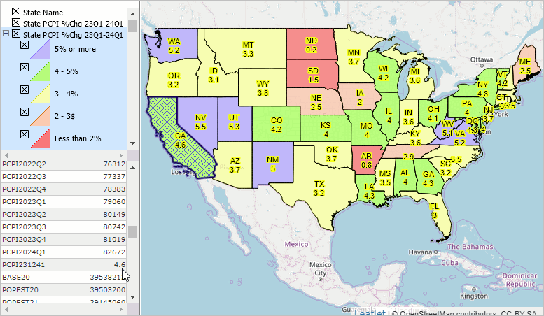 State Quarterly Per Capita Personal Income .. interactive table .. goto top Mouse-over on header column to view extended item/column name. Click ShowAll button between queries. See usage notes below table. Usage Notes Use mouse-over on header column to view extended item/column name. Click ShowAll button to reset table. Column Descriptions .. goto top
- Area Name
- Geographic summary level - Census Region code - Census Division code - State FIPS code - 4/1/2020 resident total population estimates base - 7/1/2020 resident total population estimate - 7/1/2021 resident total population estimate - 7/1/2022 resident total population estimate - 7/1/2022-7/1/2021 resident total population change - 7/1/2022-7/1/2021 resident total population percent change - Change in resident total population 4/1/2020 to 7/1/2020 - Change in resident total population 7/1/2020 to 7/1/2021 - Change in resident total population 7/1/2021 to 7/1/2022 - Births in period 4/1/2020 to 6/30/2020 - Births in period 7/1/2020 to 6/30/2021 - Births in period 7/1/2021 to 6/30/2022 - Deaths in period 4/1/2020 to 6/30/2020 - Deaths in period 7/1/2020 to 6/30/2021 - Deaths in period 7/1/2021 to 6/30/2022 - Natural change in period 4/1/2020 to 6/30/2020 - Natural change in period 7/1/2020 to 6/30/2021 - Natural change in period 7/1/2021 to 6/30/2022 - Net international migration in period 4/1/2020 to 6/30/2020 - Net international migration in period 7/1/2020 to 6/30/2021 - Net international migration in period 4/1/2021 to 6/30/2022 - Net domestic migration in period 4/1/2020 to 6/30/2020 - Net domestic migration in period 7/1/2020 to 6/30/2021 - Net domestic migration in period 7/1/2021 to 6/30/2022 - Net migration in period 4/1/2020 to 6/30/2020 - Net migration in period 7/1/2020 to 6/30/2021 - Net migration in period 7/1/2021 to 6/30/2022 Population Components of Change go to top The population in period t (P[t]) for an area is defined using the identity: P[t]:=P[t-1]+B[t]-D[t]+IM[t]+DM[t], where: - P[t] -- resident population as of 7/1/t - P[t-1] -- resident population as of 7/1/t - B[t] -- births during the period 6/30/t-1 to 7/1/t - D[t] -- deaths during the period 6/30/t-1 to 7/1/t - IM[t] -- international migration during the period 6/30/t-1 to 7/1/t - DM[t] -- domestic during the period 6/30/t-1 to 7/1/t B, D, IM and DM are the components of change. How Personal Income Differs from Money Income .. goto top .. being updated Support Using these Resources .. goto top Learn more about demographic economic data and related analytical tools. Join us in a Data Analytics Lab session. There is no fee for these Web sessions. Each informal session is focused on a specific topic. The open structure also provides for Q&A and discussion of application issues of interest to participants. ProximityOne User Group Join the ProximityOne User Group to keep up-to-date with new developments relating to geographic-demographic-economic decision-making information resources. Receive updates and access to tools and resources available only to members. Use this form to join the User Group. Additional Information ProximityOne develops geographic-demographic-economic data and analytical tools and helps organizations knit together and use diverse data in a decision-making and analytical framework. We develop custom demographic/economic estimates and projections, develop geographic and geocoded address files, and assist with impact and geospatial analyses. Wide-ranging organizations use our software, data and methodologies to analyze their own data integrated with other data. Follow ProximityOne on Twitter at www.twitter.com/proximityone. Contact ProximityOne (888-364-7656) with questions about data covered in this section or to discuss custom estimates, projections or analyses for your areas of interest. |
|
|