
|
|
|
.. tools & data; view/rank/compare/analyze housing value trends .. identifying smaller areas trending toward gentrification May 2024 .. The U.S. February 1, 2024 seasonally adjusted Housing Price Index (HPI) was 423.00 based on the base value of 100 as of January 1, 1991. This compares the the 2/1/2023 HPI of 395.19 -- a year over year increase of 7.03 percent. Monthly updates at the national level are posted here for the U.S. and by Census Region. The next release will on May 28, 2024, for April 2024. See more about the HPI below, Small geographic areas experience changing housing prices in radically different ways. ZIP code 78702 (Travis County, TX) had the highest 2023 Housing Price Index (HPI) .. 796.25 .. among all ZIP codes with an HPI of 500 or more (2000 base year, HPI=100). What about your ZIP codes of interest? Find out .. use the HPI interactive table below. The HPI has been updated through 2023. Examining Patterns of HPI by ZIP Code Relative rapid growth in housing value/appreciation can alter the underlying demographics of an area. These insights can go unrecognized using HPI for larger geographic areas such as a county or metro. Rapid acceleration of housing prices is resulting in population groups of one demographic moving away while other population groups of different demographics move in, often referred to as gentrification. The following graphic illustrates this process in the Miami, FL area. Shaded ZIP code areas have a high HPI2023 (500 or more). Labels show the ZIP code and HPI2023.  Use VDA GIS Tools to Examine HPI by ZIP Code .. under development Housing Price Index by 5-Digit ZIP Code: 2020-2023 -- interactive table .. goto top this table shows the Housing Price Index (HPI) by ZIP code with a base value of 100 in 2000. each row in the table shows HPI time series and change for a ZIP code. only those ZIP codes are included where the 2023 HPI was tabulated. HPI values are sometimes not available for each year; 2020 through 2023. use mouse-over on header column to view extended item/column name. see usage notes below table. Usage Notes Use mouse-over on header column to view extended item/column name. Click ShowAll button to reset table. • View a range of ZIP codes using base year 2000 (one row per ZIP): .. Click ShowAll button to reset table. .. Key in low-end ZIP value in edit box where default value 01001 is showing. .. Key in high-end ZIP value in edit box where default value 99901 is showing. .. Click "ZIP Min-Max" button; table refreshes showing only ZIP codes in that range. • View "Up to 5 ZIPs" .. enter 5 ZIP codes in the 5 edit boxes then click button "Up to 5 ZIPs" .. only those ZIP code with an HPI 2023 value are available. .. the default selection of ZIPs corresponds to those in MIami area as shown in graphic. Column Descriptions - ZIP5 - County - State - HPI 2020 -- Housing Price Index for 2020 - HPI 2021 -- Housing Price Index for 2021 - HPI 2022 -- Housing Price Index for 2022 - HPI 2023 -- Housing Price Index for 2023 - HPI Change 2022-23 - HPI %Change 2022-23 - HPI Change 2020-23 - HPI %Change 2020-23 Patterns of 2020-23 HPI Percent Change by ZIP Code .. goto top Create maps of HPI by 5-digit ZIP code for areas of interest using the VDAGIS tools with only a web browser. No registration, no fee, no login, nothing to install. The following graphic shows a thematic pattern map depicting HPI 2022-2023 percent change by ZIP Code for Michigan and adjacent states. The inset legend shows intervals relating HPI percent change to colors shown in the map. 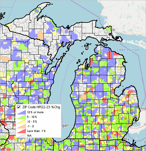
Use OpenVDA to create similar views: • Click to start OpenVDA • Click for more information about OpenVDA About the HPI .. goto top Data used in this section are based on the Federal Housing Finance Agency (FHFA) HPI estimates. See HPI FAQ. A broad measure of the movement of single-family house prices, the Housing Price Index (HPI) provides an indicator of house price trends at various geographic levels. When used with related data, it provides analysts with a measure that is useful for estimating changes in the rates of mortgage defaults, prepayments and housing affordability in specific geographic areas. The historical series starts as early as 1975 for some zip codes and census tracts, but the earlier year varies widely. HPI values reflect appraisal values and sales prices for mortgages bought or guaranteed by Fannie Mae and Freddie Mac. Transactions Covered by HPI The House Price Index is based on transactions involving conforming, conventional mortgages purchased or securitized by Fannie Mae or Freddie Mac. Only mortgage transactions on single-family properties are included. Conforming refers to a mortgage that both meets the underwriting guidelines of Fannie Mae or Freddie Mac and that does not exceed the conforming loan limit. For loans originated in 2009, the loan limit has been set by the American Recovery and Reinvestment Act of 2009. That Act, in conjuction with prior legislation, allows for loan limits up to $729,750 for one-unit properties in certain high-cost areas in the contiguous United States. The purchase-only and all-transactions HPI track average house price changes in either repeat sales or refinancings on the same single-family properties. The purchase-only index is based on more than 7 million repeat sales transactions, while the all-transactions index includes more than 50 million repeat transactions (includes refinance appraisals). Both indexes are based on data obtained from Fannie Mae and Freddie Mac for mortgages originated over the past 39 years. How the HPI is Computed .. goto top The HPI is a weighted, repeat-sales index, meaning that it measures average price changes in repeat sales or refinancings on the same properties. This information is obtained by reviewing repeat mortgage transactions on single-family properties whose mortgages have been purchased or securitized by Fannie Mae or Freddie Mac since January 1975. The HPI is updated each quarter as additional mortgages are purchased or securitized by Fannie Mae and Freddie Mac. The new mortgage acquisitions are used to identify repeat transactions for the most recent quarter and for each quarter since the first quarter of 1975. Comparison to Housing Price Index to American Community Survey Demographics The FHFA HPI compared to the American Community Survey (ACS 2022) housing value data is like comparing apples to oranges. The HPI are developed based on sale and appraisal transactions. The ACS housing value data are developed based on statistical survey responses. The ACS data do not provide a housing price index relative to a point/date in time. The ACS data do not provide a measure that enable annual comparisons. However, the HPI is a single, isolated, measure; the ACS data enable the analysis of housing value in combination with other related demographic measures. Terms of Use .. goto top There is no warranty about any aspect of the data or information presented in this section or related sections. The user of these data and information is solely responsible for any use. Support Using these Resources .. goto top Learn more about demographic economic data and related analytical tools. Join us in a Data Analytics Lab session. There is no fee for these Web sessions. Each informal session is focused on a specific topic. The open structure also provides for Q&A and discussion of application issues of interest to participants. ProximityOne User Group .. goto top Join the ProximityOne User Group to keep up-to-date with new developments relating to geographic-demographic-economic decision-making information resources. Receive updates and access to tools and resources available only to members. Use this form to join the User Group. Additional Information .. goto top ProximityOne develops geodemographic-economic data and analytical tools and helps organizations knit together and use diverse data in a decision-making and analytical framework. We develop custom demographic/economic estimates and projections, develop geographic and geocoded address files, and assist with impact and geospatial analyses. Wide-ranging organizations use our tools (software, data, methodologies) to analyze their own data integrated with other data. Follow ProximityOne on Twitter at www.twitter.com/proximityone. Contact us (888-364-7656) with questions about data covered in this section or to discuss custom estimates, projections or analyses for your areas of interest. |
|
|