
|
|
|
Geographic Summary Levels & Data Analytics October 2025 .. political and statistical data developed and published by Federal statistical agencies and others are most often estimates or tabulations for geographic areas. The term political as used here refers to the geography being defined by a state (e.g., school district) as opposed to being defined by a statistical agency (e.g., census tract). Different types of geographic areas are referred to as summary levels. The more common summary levels include the United States, states, cities and counties. Data for the United States (one geographic area) are referred to as summary statistics for "summary level" code 010. Data for a county or the set of all U.S. counties are referred to as summary statistics for summary level code 050. Summary level codes are always three digits with lead zeroes as applicable. Shortcuts to Interactive Tables by Selected Type of Geography • States .. vintage 2024 population • Metros • Congressional Districts 118th • Congressional Communities • Counties • Cities • School Districts .. characteristics & Enrollment • School Districts Finances .. sources & uses of funds • K-12 Public Schools • Public Use Microdata Areas • Urban Areas • Census Tracts • Block Groups • Census Blocks Summary Levels Summary levels are important for many reasons, but notably as a way to differentiate or classify data/datasets by geographic level. Understanding use of summary level codes/names is essential for effective use of the decennial census and American Community Survey. Use of summary level codes are a key element in using the Demographic Economic Data Explorer (DEDE). This section reviews the most common summary levels and their features, usage and characteristics. See terms of use. • Amplify your skillset .. enroll in the Using GIS & GeoDemographics short course .. learn more about using summary levels and geocodes • Join us in the Weekly Web Wessions In this Section • Geographic Areas and Summary Levels • Frequently Asked Questions The Census Bureau has developed the geographic heirarchy diagram shown below that provides a view of how selected tabulations for geographic areas or summary levels relate to each other. Many other agencies develop data for some of these geographies but oftem do not make use of the summary level codes. 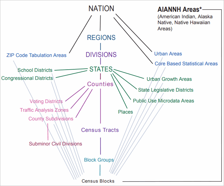
Geographic Information System Perpectives Geographic area shapefiles are developed for all of the summary levels reviewed below, and others, as a part of the Census Bureau TIGER/Line files. See the list of these shapefiles for the vintage 2025 TIGER/Line files. Detail to be added. Changing Geography Over Time While the U.S., regions, divisions, and states are contstant over time, other geographies are subject to change and in differrnt ways. Detail to be added. Geocodes and GEOIDs In data files each geographic area record is assigned a geocode that uniquely identifies that geographic area among all other geographic areas for that summary level. FIPS, ANSI, Census codes .. FIPS - Federal Information Processing Standards. Data files structured as shapefiles for use with VDAGIS tools contain a field named GEOID. The GEOID field contains a geocode consistent with the geocode structure as described below. The GEOID field (by that name) is required for some VDAGIS operations. Geocodes are always in character string structure and must include lead zeroes as applicable. Geographic Areas and Summary Levels .. goto top 101: Block A statistical area which is the smallest tabulation area of a decennial census and covering the U.S. wall-to-wall. Census blocks nest within all other census geographic areas. They are the basis for all tabulated data from the decennial census. Census block level data are only available from decennial census tabulations. About Census Blocks Geocode: A11 -- FIPS state(2)+ FIPS county(3)+Census tract(6)+Census block(4) 010: Nation The United States, excluding Puerto Rico and other island territories. 020: Region Four groups of U.S. states and the District of Columbia. About Regions Geocode: A1 030: Division Nine groups of states, subdivisions of regions. About Regions Geocode: A1 040: State One of the 50 U.S. states, Puerto Rico, and the District of Columbia. About States Geocode: A2 .. FIPS State Code 050: County U.S. county or county equivalent. Adminstrative subdivisions of states. The scope of counties included in a state, and corresponding boundaries and geocodes, may change over time. About Counties Geocode: A5 .. FIPS state(2)+county(3) 060: Census County Division (CCD), Minor Civil Division (MCD), Town (New England States Administrative or legal division of a county. The scope of CCDs included in a county, and corresponding boundaries and geocodes, may change over time. About CCDs Geocode: A10 .. FIPS state(2)+county(3)+Census CCD(5( 160: City/Place Generally incorporated cities and Census Designated Places. The scope of places included in a state, and corresponding boundaries and geocodes, may change over time. About Places Geocode: A7 .. FIPS state(2)+Census Place(5) 140: Census Tract A statistical subdivision of a county. Tract boundaries are relatively permanent from census to census. Tracts nest exactly within corresponding county or county equivalent. The scope of tracts, and corresponding boundaries and geocodes, may change over time. About Tracts Geocode: A11 .. FIPS state(2)+county(3)+Census Tract(6) 150: Block Group A statistical subdivision of a census tract. Block group boundaries are relatively permanent from census to census. Block groups nest exactly within corresponding census tract. Block groups are the lowest/smallest tabulation geography for the American Community Survey. The scope of block groups, and corresponding boundaries and geocodes, may change over time. About Block Groups Geocode: A12 .. FIPS state(2)+county(3)+Census Tract(6)+Census Block Group (1) 250: American Indian Area/Alaska Native Area/Hawaiian Home Land About American Indian Area/Alaska Native Area/Hawaiian Home Land areas Geocode: A4 .. Census AIANNH code (4) 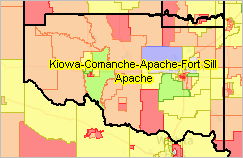
320: Metropolitan/Micropolitan Area (CBSAs) A statistical area comprised of a set of contiguous counties having a high degree of economic and social interaction. Metropolitan and micropolitan areas are collectively referred to a Core-Based Statistical Areas (CBSAs). The current vintage of CBSAs is 2023 and differs from the Census 2020 vintage. CBSAs are defined by OMB and based on data provided mainly by the Census Bureau. The scope of CBSAs, and corresponding boundaries and geocodes, may change over time. About Metros/CBSAs Geocode: A5 .. assigned by OMB 340: Combined Statistical Area (CSA) A group of two or more adjacent CBSAs. 400: Urban Area (UA) A statistical area defined by a set of census blocks each being block defined as urban or rural. Geocodes and geographic boundaries change with each new decennial census. About Urban Areas Geocode: A5 .. assigned by Census 500: Congressional District (CD) A political area defined by an adopted redistricting plan of a state. Geocodes and geographic boundaries change with newly adopted redistricting plan. About Congressional Districts Geocode: A4 .. FIPS state(2)+state assigned CD(2) 501: Congressional Community (CC) An area defined by Congressional Communities. CCs are defined using census blocks and nest exactly within congressional districts. About Congressional Communities Geocode: A7 .. FIPS state(2)+state assigned CD(2)+congressional community assigned CC(3) 610: State Legislative District (SLDU - Upper Chamber) A political area defined by an adopted redistricting plan of a state. The current vintage SLD geography is 2024 as defined by TIGER/Line vintage 2025. The current vintage SLD ACS subject matter is based on SLD2024 as defined by TIGER/Line vintage 2025. Geocodes and geographic boundaries change with newly adopted redistricting plan. About State Legislative Districts Geocode: A5 .. FIPS state(2)+census assigned SLD(3) 620: State Legislative District (SLDL - Lower Chamber) A political area defined by an adopted redistricting plan of a state. The current vintage SLD geography is 2024 as defined by TIGER/Line vintage 2025. The current vintage SLD ACS subject matter is based on SLD2024 as defined by TIGER/Line vintage 2025. Geocodes and geographic boundaries change with newly adopted redistricting plan. About State Legislative Districts Geocode: A5 .. FIPS state(2)+census assigned SLD(3) 795: Public Use Microdata Area (PUMA) A statistical area containing at least 100,000 people covering the U.S. wall-to-wall. PUMAs are entirely contained in states, do not overlap and mainly sets of contiguous census tracts defined by the Census Bureau and local stakeholder organizations. PUMAs are defined and updated with each decennial census. About PUMAs Geocode: A7 .. FIPS state(2)+census assigned PUMA(5) 860: ZIP Census Tabulation Area (ZCTA) A statistical area representation of U.S. Postal Service ZIP Codes. ZCTAs are polygons whereas USPS ZIP codes are lines and not publicly geospatialy defined. ZCTAs are defined and updated with each decennial census. About ZCTAs Geocode: A5 .. census assigned ZCTA(5) 950: School District (Elementary) A political area defined by the corresponding state. About School Districts Geocode: A7 .. FIPS state (2)+ census assigned (via NCES) SD(5) 960: School District (Secondary) A political area defined by the corresponding state. About School Districts Geocode: A7 .. FIPS state (2)+ census assigned (via NCES) SD(5) 970: School District (Unified) A political area defined by the corresponding state. About School Districts Geocode: A7 .. FIPS state (2)+ census assigned (via NCES) SD(5) 900: School District (all types) A political area defined by the corresponding state. The 900 summary level is used by ProximityOne as the collective set of summary level 950, 960, 970. About School Districts Geocode: A7 .. FIPS state (2)+ census assigned (via NCES) SD(5) Frequently Asked Questions .. goto top Q. Do census tracts include information about building types (schools, family homes, supermarkets,...) and the type of ground (asphalt, grass,..) - for example as a percentage? A. See https://proximityone.com/geo_tracts.htm Census tracts are a statistical geography (polygon areas) defined by the Census Bureau as a "tabulation area". As a geography census tracts may be shown as boundaries using a census tract shapefile. Census tract subject matter data are often displayed in tables or spreadsheets, such as shown here: https://proximityone.com/tracts.htm#table. Note in this case the census tract geocode is shown with attributes of that census tract shown in columns to the right. The developer of that table/spreadsheet determines what set of attributes will be added. So, building types could be added if that data source is available. Similarly the type of ground cover could be added if that data source is available. Census tract attributes typically published are land area, water area, and demographic-economic items from the decennial census and American Community Survey. Terms of Use .. goto top The content of this section may be freely used but may not be redistributed or copied and made a part of another document except for personal use. There is no warranty regarding the content of this section. The user is solely responsible for any use of this section. ProximityOne User Group .. goto top Join the ProximityOne User Group to keep up-to-date with new developments relating to metros and component geography decision-making information resources. Receive updates and access to tools and resources available only to members. Use this form to join the User Group. Support Using these Resources .. goto top Learn more about accessing and using demographic-economic data and related analytical tools. Join us in a Web session. No fee. Each informal session is focused on a specific topic. The open structure also provides for Q&A and discussion of application issues of interest to participants. Additional Information .. goto top ProximityOne develops geographic-demographic-economic data and analytical tools and helps organizations knit together and use diverse data in a decision-making and analytical framework. We develop custom demographic/economic estimates and projections, develop geographic and geocoded address files, and assist with impact and geospatial analyses. Wide-ranging organizations use our tools (software, data, methodologies) to analyze their own data integrated with other data. Contact ProximityOne (888-364-7656) with questions about data covered in this section or to discuss custom estimates, projections or analyses for your areas of interest. |
|
|