
|
|
-- Helping Americans Make Their Voices Heard by Congress Making your voice heard to Congress on matters that affect you ... The U.S. 435 118th Congressional Districts (Jan 3, 2023 to Jan 3, 2025) have an average population of approximately 763,000 population, larger than three states See related 118th CD demographics interactive table. The size and diversity of CDs can make it difficult to communicate effectively with Congress. Congressional Communities are subdivisions of Congressional Districts, can help Americans better have their voice heard by Congress. Learn more about the Congressional Communities program and how you can participate. Congressional Community Briefing Resources Examples of Congressional Community (CC) Briefing Resources: We will make a similar one for any CC and help your CC customize and get underway. • Arizona Congressional District 01 Congressional Communities • California Congressional District 47 Congressional Communities • Kansas Congressional District 04 Congressional Communities Mapping Congressional Districts and Congressional Communities .. using iVDA part of Visual Data Analytics .. more options available using VDAGIS Discovery What are characteristics of congressional communities and how are they changing. The start-up view is presented below in an interactive mapping window .. watch video Locate a CD or CC code .. see it on a map .. examine its demographics Click a box to view instructions. Find a Congressional District (CD) based on an address/location (zooms to CD).. enter ZIP ccde 85258 (or an address) in the searcbar.. the map view zooms-in to the CD containing the location and shows the CD crosshatched. .. view the demographic profile for this CD displayed in the lower left. .. here you can examine many demographic subject matter items for that CD. .. optionally click on other layers in the Legend Panel. .. Try a different address or location .. the view will zoom to that CD. Find a Congressional Community (CC) based on an address/location (zooms to CC)
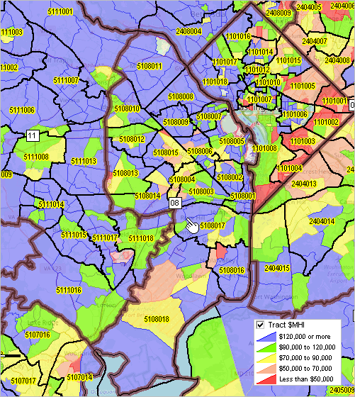
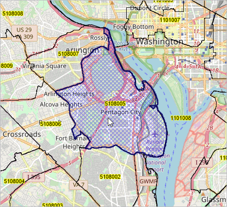
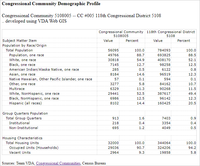
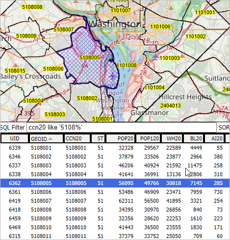
.. in the legend panel at left, click on the layer name for "Cong Community Code". It turns blue .. the active layer... enter an address "33606 N. 60th Street, Scottsdale, AZ 85266" (no quotes, not case sensitive) .. the map view zooms-in to the CC containing the location and shows the CC crosshatched. .. view the demographic profile for this CC displayed in the lower left. .. here you can examine many demographic subject matter items for that CC. .. optionally click on other layers in the Legend Panel. .. the address/location is shown by the blue marker .. this is the CC associated with the address/location used in the searchbar. .. see that the CC code is 0401017. .. see in the lower left panel the Census 2020 population was 43,515 for this CC. .. compare CC 0401017 with CD 0401 .. Try a different address or location .. the view will zoom to that CC.. Examine Urban/Rural Patterns.. in the Legend Panel, left of map, click "Urban Layers" ckeckbox on... click on an Urban Area in map to view its attributes in lower left panel. .. hide this layer by unchecking the layer checkbox. Examine Patterns of Economic Prosperity by Neighborhood/Census Tract.. in the Legend Panel, left of map, click "Tracts $MHI" ckeckbox on (scroll down)... click on an Urban Area in map to view its attributes in lower left panel. .. hide this layer by unchecking the layer checkbox. Congressional Community Focus Sections • Santa Ana, CA Center CC • Murfreesboro, TN South CC Patterns of Economic Prosperity by Congressional Community .. Washington, DC metro area; a focus on Virginia 118th CD 08 The graphic below shows Congressional Communities (CCs) with black bold boundaries and labeled with CC code. Congressional Districts are shown with bold brown boundary and white boxed CD code label. Marker shows code for VA CD 08 and is located in CC 5108017. There are 18 CCs that comprise CD 118. Patterns of economic prosperity (median household income) by tract are shown by colors/intervals in the inset legend.  Congressional Communities .. goto top The Congressional Communities program is an initiative of the nonprofit Congressional Communities organization. ProximityOne has been engaged by Congressional Communities to assist with development of CCs and CC data and to provide software, data, support and advisory services. ProximityOne and Congressional Commmunities are separate organizations. As a resident, constituent, of a congressional district, how do you make your voice heard on key issues affecting you, your household and your local living environment in Congress? Congressional Communities, subdivisions of Congressional Districts, can help Americans better have their voice heard by Congress. Congressional communities are developed by assembling 2020 census blocks and block groups by the Congressional Communities team using the ProximityOne CV XE GIS software and state GIS projects. Congressional districts are sub-divided into CCs, sets of contiguous blocks/block groups, that are typically around 40,000 population based on a range of socioeconomic, geopolitical features, geographic and other factors. A set of Census 2020 and American Community Survey demographics are developed for each CC. These demographics help CC stakeholders better understand characteristics and needs of their CCs and other CCs. The sum of the total population (and other demographic attributes) for all CCs nesting in a CD equals the CD total population. The CD demographics are the aggregates of the associated CCs, yet the CCs have their own unique characteristics. Unlike census tracts, averaging 4,000 population, CCs nest within CDs and better reflect neighborhood-plus characteristics. Unlike cities, CCs include rural and suburban areas and sub-divide larger cities. Where is my Congressional Community? .. goto top You can use the VDA Web GIS to locate/view a CC based on an address. Follow these steps: Start VDA Web GIS -- https://vdagis.com .. no fee and learn more about VDA Web GIS getting started Next, select the Congressional Communities Project After VDA map interface displays, proceed as follows: Enter an address in edit box above the map window then click the Find Address button. .. for this example, use Reagan National Airport" (no quotes) .. the map window refreshes with a zoom to that location and shows a marker at that address. Click the marker to show the CC associated with that location. .. the CC area shows in the Map Window (cross-hatched) and a CC Profile displays in the lower left panel.  See in the profile that this is CC 5108005 (State 51 and 118th CD 08 and CC 005) .. also sse the Census 2020 population for this CC is 56,095. .. the Census 2020 percent majority-minority population is 47.5. Click the HMTL button, lower left below profile for a Web-based page view To view all CCs and their codes, click on the two layers: Cong Community Code and Cong Community Comparative Congressional Community - Congressional District Demographic Profile .. goto top Examine how the demographics of a CC relate to the corresponding CD by clicking Tools>Profiles>CC Profile. Using CC 5108005, the profile opens in a new page as shown here:  Examining All CCs in a CD .. goto top The following graphic shows another way to examine how the CCs in a CD relate to each other. This tabular view shows all CCs in VA 118th CD 08 as rows with demographics arrayed across columns. CC 5108005 is highlighted. 
To develop the above view, proceed from above. Click the Table/Query button at far right below the Map Window. .. the view refreshes showing the data grid/table below the Map Window. To view the CCs in VA CD 118, enter the query <ccn20 like '5108%'> (no pointy brackets) and click the query button. .. the grid refreshes showing the 18 CC rows for this CD To view the CC 5108005, click on that row, it turns blue, then click the button "Click geography row to display". .. the Map Window view zooms to that CC. More About Congressional Communities Many CDs cover large areas, are elongated and extend over long distances and include areas very different from one another. Residents of congressional districts need a way to more effectively communicate their needs and participate in policy development. Providing a better voice from CD component areas can improve through Congressional Communities. Congressional Communities (CCs) are geographic subdivisions of Congressional Districts (CDs). Developed and coordinated by the non-profit Congressional Communities organization, CCs offer a local identity -- characteristics more of that locale than the CD overall. Congressional Communities are intended to better enable Americans to make their voices heard by Congress. How to Participate .. goto top Click here to sign-up and participate in the Congressional Communities program. About VDA GIS VDA Web GIS is a decision-making information resource designed to help stakeholders create and apply insight. Use VDA Web GIS with only a Web browser; nothing to install; GIS experience not required. VDA Web GIS has been developed and is maintained by Warren Glimpse, ProximityOne (Alexandria, VA) and Takashi Hamilton, Tsukasa Consulting (Osaka, Japan). Support Using these Resources .. goto top Learn more about accessing and using demographic-economic data and related analytical tools. Join us in a Data Analytics Lab session. There is no fee for these one-hour Web sessions. Each informal session is focused on a specific topic. The open structure also provides for Q&A and discussion of application issues of interest to participants. Additional Information .. goto top ProximityOne develops geodemographic-economic data and analytical tools and helps organizations knit together and use diverse data in a decision-making and analytical framework. We develop custom demographic/economic estimates and projections, develop geographic and geocoded address files, and assist with impact and geospatial analyses. Wide-ranging organizations use our tools (software, data, methodologies) to analyze their own data integrated with other data. Follow ProximityOne on Twitter at www.twitter.com/proximityone. Contact us (888-364-7656) with questions about data covered in this section or to discuss custom estimates, projections or analyses for your areas of interest. |
|
|