
|
|
|
-- state legislative district geographic, demographic, economic characteristics -- current incumbency, emails, party details -- demographic characteristics State Legislative Districts (SLDs) for the 2024 cycle are the electoral boundaries used for state legislative elections held on November 5, 2024. These districts are drawn for both the upper and lower chambers of state legislatures, which are often referred to as the Senate and House, respectively. Key points about the 2024 State Legislative Districts: Redistricting: The boundaries for state legislative districts are typically redrawn every 10 years following the U.S. Census to reflect population shifts. However, some states made changes to their district maps for the 2024 election cycle. For the 2024 cycle, eight states redrew their upper chamber plans and eleven states redrew their lower chamber plans. Number of Districts: There were 1,960 upper chamber (senate) districts and 4,874 lower chamber (house) districts in the 2024 cycle. Member Details: Incumbent name, email, URL, address, party, phone and more updated monthly .. only here. Elections: In 2024, elections were held for 85 state legislative chambers across 44 states, encompassing 5,807 of the country's 7,386 state legislative seats. Additionally, elections were held for nine legislative chambers in U.S. territories and Washington, D.C. Partisan Impact: The 2024 state legislative elections resulted in some shifts in partisan control. The Michigan and Minnesota state Houses changed party control, and several states saw changes in their veto-proof supermajority statuses. For example, Republicans gained control of the Michigan House from Democrats and won a tie in the Minnesota House. Data and Maps: The data and reference maps for the 2024 State Legislative Districts, including demographic information from the 2020 Census, are provided here. The American Community Survey (ACS) also produces annual data for these districts. Finding and Examining Your SLD 2024 with iVDA .. how to find your state legislative district, find by an address/location, view map - use iVDA below; uncheck County layer. Click on SLDU or SLDL layer. - enter address in Search Bar and press Enter. .. explore demographic characteristics of any state legislative district. - use iVDA below; uncheck County layer. Click on SLDU or SLDL layer. - choose Tools>Layer Editor; select item to show as label; see metadata below - use other options in layer editor. zoom to location of interest. .. using the VDA Table feature to compute and view new variables There are 4,874 lower chamber (house) state legislative districts (SLDL) and 1,960 upper chamber (senate) state legislative districts (SLDU) in the 2024 cycle. Data for the SLD 2024 reflect changes to the SLD 2022. Using the SLD 2024 Project with iVDA .. the current page is https://proximityone.com/sld2024.htm. .. use the project with alternative Visual Data Analytics Web4 VDAW4 for full screen view with more options. Organization amd Use of SLD2024 Project Layers in Legend: - States - CBSA/MSA - Cities %PopChg 20-24 - County Annual Population - SLD Lower 2024 -- for boundary and SLD Code as "upper" label - SLD Lower Feature 2004 -- for boundary and "selected feature" such as name as "lower" label - SLD Lower 2024 Party -- three party thematic map - SLD Upper 2024 -- for boundary and SLD Code as "upper" label - SLD Upper Feature 2024 -- for boundary and "selected feature" such as name as "lower" label - SLD Upper 2024 Party -- three party thematic map - BaseLayer1 - States1 SLD 2024 changes since SLD 2022 Eight states (Georgia, Minnesota, Montana, North Carolina, North Dakota, Ohio, Washington, and Wisconsin) delineated new state legislative district-upper (SLDU) chamber plans for the 2024 election cycle. Eleven states (Georgia, Michigan, Minnesota, Montana, New York, North Carolina, North Dakota, Ohio, South Carolina, Washington, and Wisconsin) delineated new state legislative district-lower (SLDL) chamber plans for the 2024 election cycle. A new SLDU plan was approved for Michigan after the Census Bureau collected these boundaries but still prior to the 2024 elections. The Michigan Senate (upper) chamber is not up for reelection until 2026, so that plan is not reflected in the geographic and data releases below. It will instead be captured in our 2026 collection cycle. All other states, the District of Columbia, and Puerto Rico had no changes to their state legislative district (SLD) boundaries from the 2022 cycle. SLD 2024 -- 2020 Census Data Census 2020 Demographic Profile 1 .. 160 items derived from 119 Congressional District update released December 2024 .. Metadata SLD 2024 -- American Community Survey (ACS) Data The American Community Survey (ACS) produces data for state legislative districts (SLDs) annually, as part of the 5-year estimates data releases. ACS data for the 2024 SLDs will not be released until December 2025. These data will be available via VDA tools by mid-December. SLD 2024 -- Voting Results and Incombency from 2024 Elections Start the (SLD2024) GIS project using iVDA or VDA4. The start-up view of the SLD2024 GIS project using iVDA is shown below. Using iVDA with SLD2024 Project .. goto top .. the page being viewed is located at https://proximityone.com/sld2024.htm Static view of the SLD Upper Chamber (4,874 areas) U.S. Lower 48 States 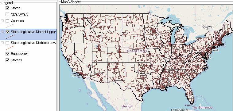 Static view of the SLD Lower Chamber (1,960 areas) U.S. lower 48 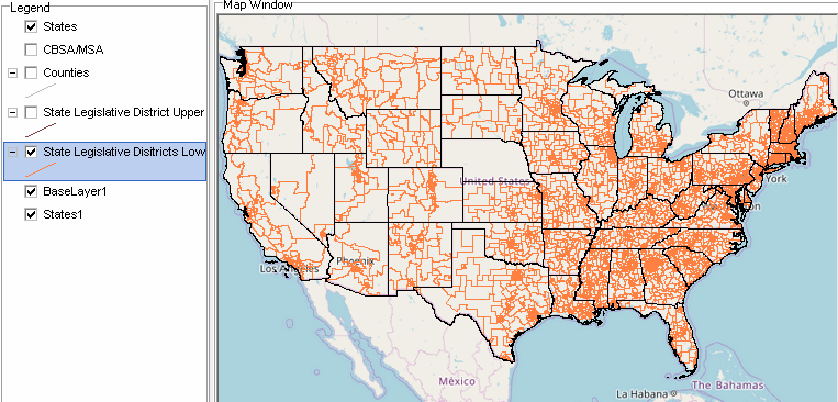 Using the VDA Table Feature to Compute and View New variables Most of the 160 items contained in the DP1 datasets are whole numbers or like total population (D001TPOP) or Hispanic population (D157HISP). To create and view the percent Hispanic population requires use of the Table feature of VDA tools, explained here. In this example, the default County layer setting is unchecked and the SLD Upper is check on. Next, the Table feature is started. Start the Table feature by clicking the rightmost Table-Grid marker below the map window. The table for the active layer is now shown below. 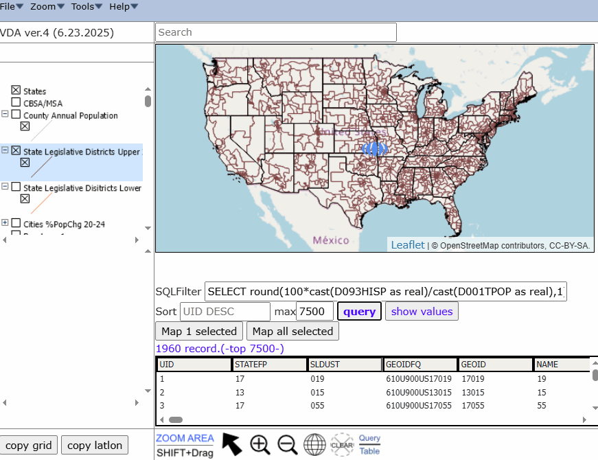 The SQL Filter value: SELECT cast(D157RVACR as real) as value where value > 0 SELECT round(100*cast(D093HISP as real)/cast(D001TPOP as real),1) as value where value > 0 entered then Query is clicked resulting in the next view. 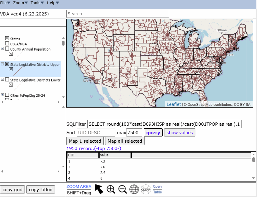 The "Show Values" button is clicked, resulting in the desired map shown below. 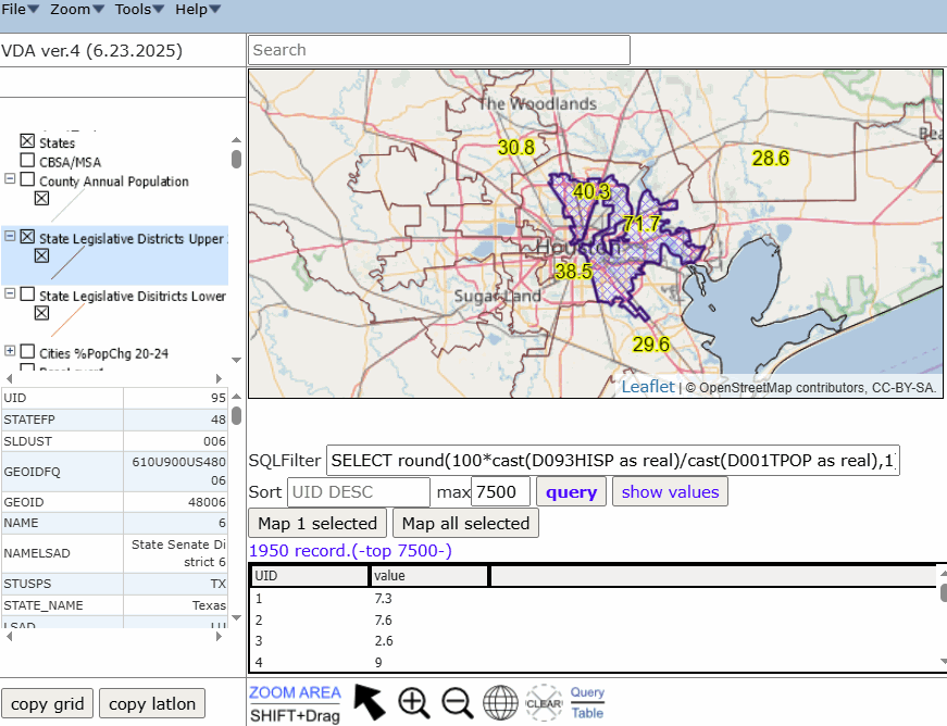 The highlighted SLDU has a percent hispanic population of 71.7 .. this is SLDU 48006 as shown in the profile at lower right Highest Senate SLD 2024 Rental Vacancy Rate (percent) .. goto top The Rental Vacancy Rate (Percent), item D157RVACR, is one of the items already shown as a percent. 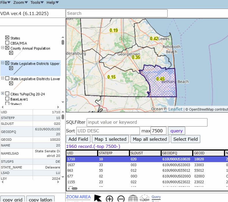 The rental vacancy rate is the proportion of the rental inventory that is vacant for rent. The rates are computed using the following formula.
                                  [Vacant year-ound units for sale only}
 Rental Vacancy Rate (%) = 100 *  ---------------------------------------
                                    [Owner occupied units]
                                   + [Vacant year-round units rented awaiting occupancy]
                               + [Vacant year-round units for sale only]
.. Harris County (Houston) area; click for larger view 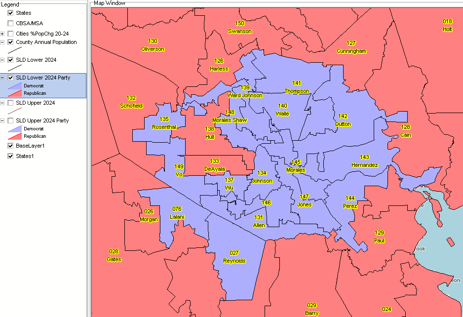 Texas State Legislative Districts 2024 Upper Incumbents & Party .. goto top .. Harris County (Houston) area; click for larger view 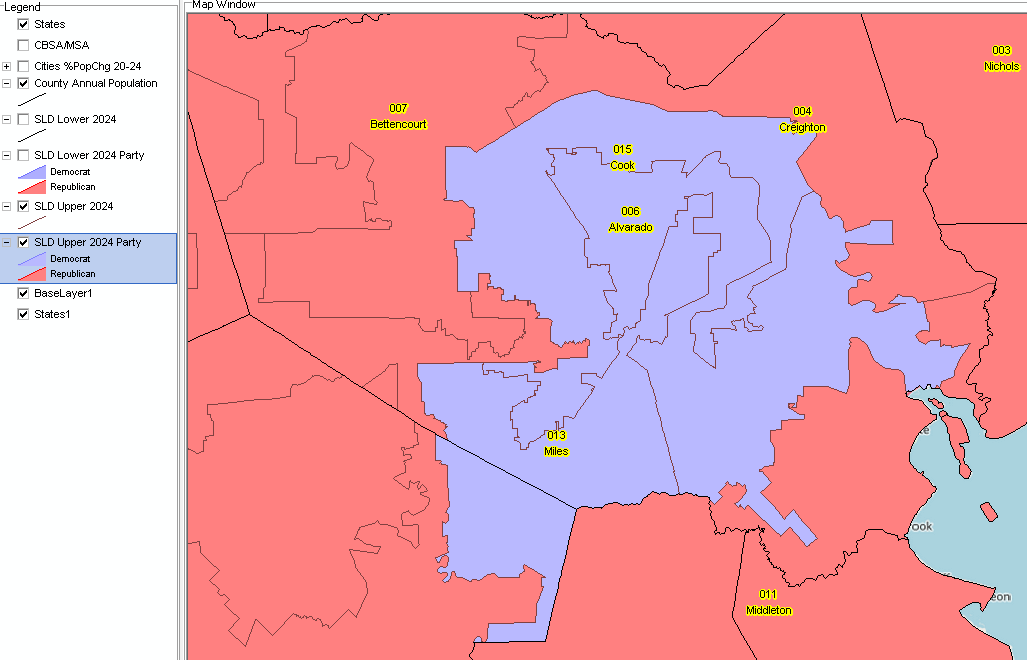 Role of GIS and State Legislative Districts 2024 A Geographic Information System (GIS) is a computer -based tool that allows users to store, analyze, visualize, and interpret geographic data. Geographic data, also known as spatial or geospatial data, identifies the location of features on earth. GIS combines the visual elements of maps with the ability to link characteristics about those features in datasets. This relationship allows GIS to locate, display, analyze, and model data. GIS technology integrates geographic data with statistical and adminstrative data using statistical methods and analytics. These abilities make GIS valuable to a wide range of public and private enterprises for explaining events, predicting outcomes and planning strategies. And collaborating on those issues. Terms of Use .. goto top There is no warranty regarding any aspect of this using this project. The user is solely responsible for any use made of iVDA or data contained in project files. About iVDA & VDAGIS .. goto top iVDA is an HTML iframe embedded version of VDA Web GIS. VDAGIS tools and data have been developed and are updated/supported by Warren Glimpse/ProximityOne/Alexandria, VA USA and Takashi Hamilton/Tsukasa/Osaka, Japan. Support Using these Resources .. goto top Learn more about census tract demographic economic data and related analytical tools. Join us in a Data Analytics Lab session. There is no fee for these informal sessions focused on your interests. The open structure provides for Q&A and discussion of application issues of interest to participants. Additional Information .. goto top ProximityOne develops geographic-demographic-economic data and analytical tools and helps organizations knit together and use diverse data in a decision-making and analytical framework. We develop custom demographic/economic estimates and projections, develop geographic and geocoded address files, and assist with impact and geospatial analyses. Wide-ranging organizations use our tools (software, data, methodologies) to analyze their own data integrated with other data. Contact ProximityOne (888-364-7656) with questions about data covered in this section or to discuss custom estimates, projections or analyses for your areas of interest. |
|
|