
|
|
|
The U.S. population age 65 and older rose by 3.1% (to 61.2 million) while the population under age 18 decreased by 0.2% (to 73.1 million) from 2023 to 2024, to the Vintage 2024 Population Estimates released by the Census Bureau on June 26, 2025. This release marks the end of the 2024 Vintage estimates. The 2025 Vintage estimates begins with the U.S. by state estimates in December 2025. In 2024, the U.S. median age reached a new record high of 39.1, up 0.1 years from 2023, and up 0.6 years from 38.5 in 2020. Regionally, the West (38.4) and South (38.8) had the lowest median ages in 2024; the Northeast had the highest (40.6), followed by the Midwest (39.3). Maine's population in 2024 was the oldest, with a median age of 44.8; Utah's was the youngest (32.4). The median age across all counties in 2024 ranged between 20.9 and 68.1; 74% (2,340 of 3,144) had a median age at or above the median age for the nation. Women outnumbered men by 3.4 million, making up 50.5% of the U.S. population in 2024. Use the VDAGIS tools and associated GIS project to examine these age/gender data by county. Explore demographic characteristics of any county in combination with other data. - use iVDA below; uncheck County layer. - choose Tools>Layer Editor; select item to show as label; See list of variables below - use other options in layer editor. zoom to location of interest. Using iVDA with the Population Age/Gender GIS Project .. alternatively use the VDAW4 tool Static view of the U.S. by County -- Exploring Kansas -- Zoom in with Labels 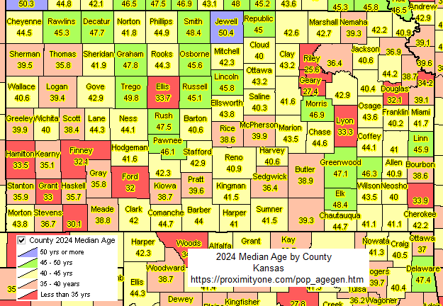 Fields/Variables Included CTYNAME County Name STAB State USPS ST1 State FIPS CTY1 County FIPS GEOID GEOID YEAR Year (6) POPEST Total population POPESTM Total population - male POPESTF Total population - female P0004 Population ages 0-4 -- total P0004M Population ages 0-4 -- male P0004F Population ages 0-4 -- female P0513 Population ages 13 -- total P0513M Population ages 13 -- male P0513F Population ages 13 -- female P14 Population ages 14 -- total P14M Population ages 14 -- male P14F Population ages 14 -- female P1824 Population ages 18-24 -- total P1824M Population ages 18-24 -- male P1824F Population ages 18-24 -- female P16UP Population ages 16 up -- total P16UPM Population ages 16 up -- male P16UPF Population ages 16-up -- female P18UP Population ages 18 up -- total P18UPM Population ages 18 up -- male P18UPF Population ages 18 up -- female P1544 Population ages 15-44 -- total P1544M Population ages 15-44 -- male P1544F Population ages 15-44 -- female P2544 Population ages 25-44 -- total P2544M Population ages 25-44 -- male P2544F Population ages 25-44 -- female P4564 Population ages 45-64 -- total P4564M Population ages 45-64 -- male P4564F Population ages 45-64 -- female P65UP Population ages 65 up -- total P65UPM Population ages 65 up -- male P65UPF Population ages 65 up -- female P04 Population ages 4 -- total P04M Population ages 4 -- male P04F Population ages 4 -- female P59 Population ages 59 -- total P59M Population ages 59 -- male P59F Population ages 59 -- female P1014 Population ages 10-14 -- total P1014M Population ages 10-14 -- male P1014F Population ages 10-14 -- female P1519 Population ages 15-19 -- total P1519M Population ages 15-19 -- male P1519F Population ages 15-19 -- female P2024 Population ages 20-24 -- total P2024M Population ages 20-24 -- male P2024F Population ages 20-24 -- female P2529 Population ages 25-29 -- total P2529M Population ages 25-29 -- male P2529F Population ages 25-29 -- female P3034 Population ages 30-34 -- total P3034M Population ages 30-34 -- male P3034F Population ages 30-34 -- female P3539 Population ages 35-39 -- total P3539M Population ages 35-39 -- male P3539F Population ages 35-39 -- female P4044 Population ages 40-44 -- total P4044M Population ages 40-44 -- male P4044F Population ages 40-44 -- female P4549 Population ages 45-49 -- total P4549M Population ages 45-49 -- male P4549F Population ages 45-49 -- female P5054 Population ages 50-54 -- total P5054M Population ages 50-54 -- male P5054F Population ages 50-54 -- female P5559 Population ages 55-59 -- total P5559M Population ages 55-59 -- male P5559F Population ages 55-59 -- female P6064 Population ages 60-64 -- total P6064M Population ages 60-64 -- male P6064F Population ages 60-64 -- female P6569 Population ages 65-69 -- total P6569M Population ages 65-69 -- male P6569F Population ages 65-69 -- female P7074 Population ages 70-74 -- total P7074M Population ages 70-74 -- male P7074F Population ages 70-74 -- female P7579 Population ages 75-79 -- total P7579M Population ages 75-79 -- male P7579F Population ages 75-79 -- female P8084 Population ages 80-84 -- total P8084M Population ages 80-84 -- male P8085F Population ages 80-84 -- female P85UP Population ages 85 up -- total P85UPM Population ages 85 up -- male P85UPF Population ages 85 up -- female MEDAGE Median age MEDAGEM Median age - male MDEAGSF Median age - female Role of GIS and Population by Age/Gender A Geographic Information System (GIS) is a computer -based tool that allows users to store, analyze, visualize, and interpret geographic data. Geographic data, also known as spatial or geospatial data, identifies the location of features on earth. GIS combines the visual elements of maps with the ability to link characteristics about those features in datasets. This relationship allows GIS to locate, display, analyze, and model data. GIS technology integrates geographic data with statistical and administrative data using statistical methods and analytics. These abilities make GIS valuable to a wide range of public and private enterprises for explaining events, predicting outcomes and planning strategies. And collaborating on those issues. Terms of Use .. goto top There is no warranty regarding any aspect of this using this project. The user is solely responsible for any use made of iVDA or data contained in project files. About iVDA & VDAGIS .. goto top iVDA is an HTML iframe embedded version of VDA Web GIS. VDAGIS tools and data have been developed and are updated/supported by Warren Glimpse/ProximityOne/Alexandria, VA USA and Takashi Hamilton/Tsukasa/Osaka, Japan. Support Using these Resources .. goto top Learn more about census tract demographic economic data and related analytical tools. Join us in a Data Analytics Lab session. There is no fee for these informal sessions focused on your interests. The open structure provides for Q&A and discussion of application issues of interest to participants. Additional Information .. goto top ProximityOne develops geographic-demographic-economic data and analytical tools and helps organizations knit together and use diverse data in a decision-making and analytical framework. We develop custom demographic/economic estimates and projections, develop geographic and geocoded address files, and assist with impact and geospatial analyses. Wide-ranging organizations use our tools (software, data, methodologies) to analyze their own data integrated with other data. Contact ProximityOne (888-364-7656) with questions about data covered in this section or to discuss custom estimates, projections or analyses for your areas of interest. |
|
|