
|
|
|
-- determine/assign latitude-longitude and geocodes to addresses -- assign subject matter attributes/demographics to addresses The AddressCoder software is used to assign latitude-longitude coordinates and geocodes to addresses. Geocodes include the census block where the address is located. The addresses are provided by the user and may be from any source. The AddressCoder Level 1 software is available for personal use to ProximityOne User Group members at no fee. See installation details. See terms of use. April 2022 update. The all new AddressCoder 2022 (Windows-based application) for release in May 2022 includes: • your address data never leave the your computer. • there are no limits of how many addresses you can geocode. • uses an updating local geocoding base file .. Digital Map Database (DMD): - coding with intersection to intersection street segment base file. - uses augmented Census sourced TIGER edge files. .. fills in gaps in missing road segments, segment names & address ranges. - optionally housed on an solid state disc device connected to your computer. .. loaded with DMD, ready to use. • latitude-longitude coding based on your address file. - latitude-longitude appended to address record output file. • Census 2020 block coding - appends 15 character code to address record output file. • optional appending of demographic data to the outout file: - Census 2020 demographic data at the block level - ACS 2020 demographic data at the block group level • annual license. Illustrating Geocoded Locations in Context How the geocoded data can be used .. the following graphic shows use of geocoded locations (red markers) in context of the Kansas City metro (bold brown boundary), 115th Congressional Districts (CDs -- bold black boundary, white labels) and patterns of median household income by census tract. Pointer in 115th CD "2003" -- Kansas CD 03. 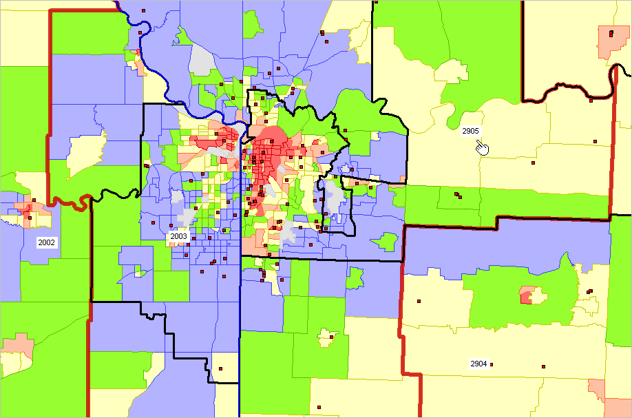 ... View developed using CV XE GIS. Map your own locations with geography of interest. See more about using geocoded locations in GIS applications below in this section Related Resources • Location-Based Geocodes & Demographics .. enter an address; geocodes & demographic attributes shown on return page • CV XE GIS software .. import and map/geospatially analyze geocode address data Using the AddressCoder To use the AddressCoder software, start the application and open an address file. With the address file open, click the Start button (left panel) to process the file that has been opened. As address records are processed, the latitude, longitude, 115th congressional district code and census block code are determined. These items are output immediately to the grid showing in the address line/row. At the end of the processing the updated grid is output to an Excel (XLS) file. See about installing the application below in this section. Start-up View The following graphic shows the AddressCoder start-up view. The grid is populated with the addresses contained in the address file c:\addresscoder\address_set2.xls (provided during installation). 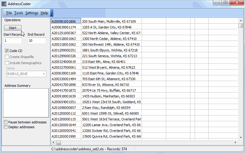 Address Processing View The following graphic shows the view after processing has been completed. The grid is populated with the addresses contained in the address file c:\addresscoder\address_set2.xls updated with the latitude, longitude, congressional district code and block code. 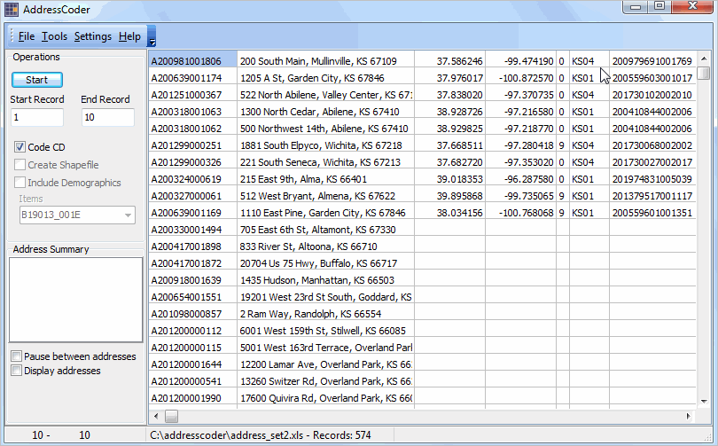 As addresses are processed, the updated address row/record is displayed in the listbox shown in the left panel. Opening an Address File To open an address file use the File>Open Address File on the toolbar. A file open dialog is started and the input file (must be an Excel/XLS structured file) to be processed may be selected from any drive/folder. 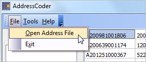 A new address input file may be opened at any time: upon start-up or after another address file has been processed. Address Input Files The address input file must be in Excel (XLS) structure. Two columns are required in the XLS input file: address ID (column 1) and fully formed one-line address (column 2). The one-line address should be structured like "221 South Seneca, Wichita, KS 67213" (omit quotes). Coding rules include: • 5-digit ZIP codes are optional but suggested. • Column 1 (ID) may be left empty/blank. • The address string is not case sensitive. • For most accurate processing, special characters should be avoided. • There is no need nor provision for "second line" in the address; do not use second line address (such as Apt. 1). • Commas delimiting the address field components (street, city, state) are not required but suggested. Output Files Upon completion of coding, the updated grid with four output fields is written to an Excel (XLS) file and a completion message is displayed. If the input file is named c:\addresscoder\address_set1.xls, the output file will be named c:\addresscoder\address_set1_coded.xls. The characters "_coded" are inserted into the input file name before the dot and extension (before .xls). If the output file exists, it will automatically overwritten. At that time the program may be closed or another address file may be opened and processed. During processing, as each address is coded, the results of coding and data assignment are written to the file c:\addresscoder\coded.dbf. This file is overwritten each time the Start button is used. In the event a long geocoding process is interrupted, the coded.dbf file contains all records processed up to that point (last address processed). Statusbar The statusbar is shown at the bottom of the AddressCoder form. Various information is presented in the statusbar. When an address file is opened, the name/path of the file is shown in panel 2 of the statusbar. The number of records appears following the file name. As processing occurs, the record number is shown in panel 1 of the statusbar. Settings Access the Settings form from the main menu: File>Settings>Start-up INI. Use the Setting form to set selected attributes for AddressCoder start-up and operation. Mapping/Geospatial Analysis Applications How the geocoded data can be used .. the following graphic shows use of geocoded locations (red markers) in context of the Dallas, TX city (cross-hatched area), counties and patterns of median household income by census tract. This view shows geocoded points based on the address file c:\addresscoder\address_set3.xls (Trader Joes locations in Texas). The shapefile created by AddressCoder is shown visually using the CV XE GIS softwrae. The identify tool (at pointer) is used to click on location/marker and display a mini-profile. The mini-profile shows attributes for this point that were generated using AddressCoder. The shapefile created by AddressCoder can be used with any GIS software. 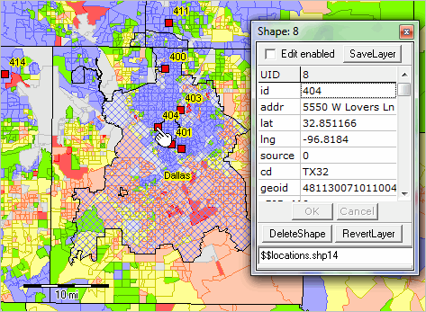 ... View developed using CV XE GIS. Map your own locations with geography of interest. Zoom-in View A zoom-in view to the above location shows this address in context of streets and other features. The marker is labeled with the address used in the original source file (c:\addresscoder\address_set3.xls). 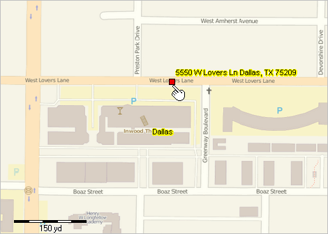 ... View developed using CV XE GIS. Installation .. goto top Install the AddressCoder software on any Windows computer. Internet is required to install and use the software. Run the AddressCoder Installer. When prompted, enter your userid and password (both case sensitive) provided separately. By default all files installed are located in the folder c:\addresscoder (recommended). The AddressCoder software can be installed on any drive/folder. However, the documentation assumes that the application has been installed in c:\addresscoder. Upon completing installation, the application is ready to use. To remove the application entirely, delete the c:\addresscoder folder. Included with the installer are three sample address files. The files are named c:\addresscoder\address_set?.xls where ? has the values 1, 2, 3. The files are included to illustrate the process of opening a different address input file. At start-up, the file c:\addresscoder\address_set1.xls is automatically opened. Terms of Use AddressCoder is proprietary software resource developed by ProximityOne. Licensed users may use AddressCoder Level 1 for personal use only and subject to installation terms. The software may not be distributed to others. The software is not authorized for use in consulting, professional advice, business or commercial applications. While best efforts are made to develop the most accurate geodcoding and address processing, there is no warranty about any aspect of use of the AddressCoder software. Any use of the software is solely at the discretion of the user. ProximityOne User Group -- goto top Join the ProximityOne User Group to keep up-to-date with new developments relating to metros and component geography decision-making information resources. Receive updates and access to tools and resources available only to members. Use this form to join the User Group. Support Using these Resources Learn more about accessing and using demographic-economic data and related analytical tools. Join us in a Data Analytics Lab session. There is no fee for these one-hour Web sessions. Each informal session is focused on a specific topic. The open structure also provides for Q&A and discussion of application issues of interest to participants. Additional Information ProximityOne develops geodemographic-economic data and analytical tools and helps organizations knit together and use diverse data in a decision-making and analytical framework. We develop custom demographic/economic estimates and projections, develop geographic and geocoded address files, and assist with impact and geospatial analyses. Wide-ranging organizations use our tools (software, data, methodologies) to analyze their own data integrated with other data. Follow ProximityOne on Twitter at www.twitter.com/proximityone. Contact us (888-364-7656) with questions about data covered in this section or to discuss custom estimates, projections or analyses for your areas of interest. |
|
|