
|
|
|
Census Tract Demographic Economic Change & Trends -- 5-year change ..compare attributes .. ACS 2012 .. ACS 2017 -- tools & data to examine characteristics & change
August 2019 .. examine census tract demographic-economic characteristics and trends using the interactive table below. Compare/contrast tracts based on data from the ACS 2012 (centric to 2010) and ACS 2017 (centrics to 2015, released December 2018). Together these data provide insights into tract demographics and change, 2010 to 2015. See terms of use below. ProximityOne uses these and related data to develop and analyze annual census tract demographic-economic estimates and projections. Patterns of Median Household Income %Change by Census Tract The graphic below shows patterns of economic prosperity change (%MHI ACS 2012 to ACS 2017) by tract in the Dallas metro area. 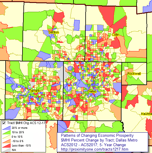 - view developed using ProximityOne CV XE GIS and related GIS project. Using the Interactive Table -- goto top Use the interactive table below to view, query, rank, compare selected characteristics of the population, housing, educational attainment and income for census tracts based on ACS 2012 5-year, and ACS 2017 5-year data. Hundreds of additional items are available. Census Tract Demographic Economic Characteristics & Trends interactive table Compare attributes over 5 years .. ACS 2012 .. ACS 2017 Click ShowAll button between Find/Queries. Use mouseover on column header to view column description. See usage notes below table. See related tables -- interactive tables. Usage Notes • If table not showing any rows; click ShowAll button below table. • Use vertical and horizontal scroll bars to navigate up/down or left/right. • Adjust column widths using column divider between header cells. • Find a census tract based on an address .. .. option 1 - use the CV XE GIS Locate feature .. option 2 - use the Geocoder - on return page (enter address, click Find), scroll down to Census Tracts: - the 11 character tract code is shown on line with "GEOID:" • Find TractGeoID> button .. use to select area based on exact census tract based on its unique 11-character code in column 1. .. key in exact SSCCCTTTTTT code to right of Find TractGeoID> button then click button. • Find StCty> button .. use to select area based on exact state+county FIPS code based on its unique 5-character code in column 4. .. key in exact SSCCC code to right of Find StCty> button then click button. • Find CtyName> button .. use to select area based on exact partial spelling (case sensitive) of county name in column 5. .. key in exact spelling to right of Find CtyName> button then click button. • CBSA> button -- use to select districts in a specified metro/CBSA .. get metro 5-character code here .. paste the 5-character metro code in the edit box to right of CBSA> button. .. overwriting the value 19100. .. click the CBSA> button ... table refreshes with all areas in specified metro. • Click ShowAll button between specific area queries. • Cells with negative value (-1 in ACS col; -999 in change col) could not be estimated (for this geography and this time frame). Terms of Use. Data provided via this section are intended for personal, non-business use only. The data may not be used in business, consulting or for-fee applications. The data may not be redistributed. Businesses and commercial users may subscribe to use these data and tools. It is requested that all use reference the source as ProximityOne (http://proximityone.com/tracts.htm) based on data sourced in part from the Census Bureau/American Community Survey. Any use of these resources is solely at the discretion of the user. There is no warranty or guarantee of any type. ProximityOne User Group Join the ProximityOne User Group to keep up-to-date with new developments relating to metros and component geography decision-making information resources. Receive updates and access to tools and resources available only to members. Use this form to join the User Group. Support Using these Resources Learn more about accessing and using demographic-economic data and related analytical tools. Join us in a Data Analytics Lab session. There is no fee for these one-hour Web sessions. Each informal session is focused on a specific topic. The open structure also provides for Q&A and discussion of application issues of interest to participants. Additional Information ProximityOne develops geodemographic-economic data and analytical tools and helps organizations knit together and use diverse data in a decision-making and analytical framework. We develop custom demographic/economic estimates and projections, develop geographic and geocoded address files, and assist with impact and geospatial analyses. Wide-ranging organizations use our tools (software, data, methodologies) to analyze their own data integrated with other data. Follow ProximityOne on Twitter at www.twitter.com/proximityone. Contact us (888-364-7656) with questions about data covered in this section or to discuss custom estimates, projections or analyses for your areas of interest. |
|
|