
|
|
|
We live in a data-driven world where public use data, combined with data from other sources, has become vital. New data and tools, with increased availability, are evolving in their usefulness for application to the practical problems in government, business, academia and many facets of our personal lives. Until now, many of these data, and ways to integrate and analyze mixed source data, have been difficult and costly to access and use. The Virginia State & Regional Decision-Making Information (SRDMI) database and GIS Project empowers policy-makers, planners, researchers, analysts to examine wide ranging demographic-economic characteristics and trends. It is one of many Geographic Information System (GIS) projects accessible using the VDA Web GIS. Use these reources to develop wide-ranging reference and analytical views and perform geospatial analyses; see examples below. Add your own data/layers. See about the SRDMI structure and content. Patterns of Economic Prosperity; Virginia by Census Tract The start-up view shows patterns of economic prosperity based on American Community Survey 2020 median household income by census tract. 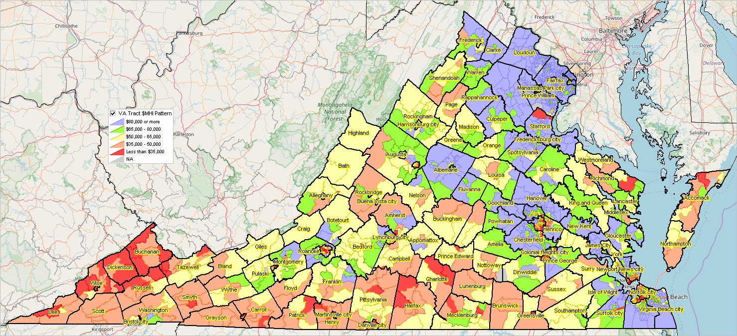 .. click graphic for larger view; larger view shows counties. .. expand browser view to full screen for best view. How Users Benefit • use Web-based global GIS resource; nothing to install. • examine K-12 schools in context of neighborhoods. • see how the 118th Congressional Districts differ from the 116th • keep up with new demographics for Congressional Districts & Virginia legislative districts • find your Congressional Community .. view related geography and characteristics. • key in your address; click marker to view your neighborhood characteristics. • examine demographic-economic patterns for geographies not elsewhere available. • more, list to be extended Using Virginia SRDMI with VDA Web GIS .. goto top .. patterns of median household income (ACS2020) by Census 2020 census tract .. zoom-in to Alexandria, VA showing map/table view .. query geoid like '51510%' and mhia20>200000 applied .. Alexandria tracts where median household income is greater than $200,000  .. see notes on creating this type of view below About VDA Web GIS .. goto top VDA Web GIS has been developed by Warren Glimpse/ProximityOne/Alexandria, VA USA and Takashi Hamilton/Tsukasa/Osaka, Japan. All that is required to use VDA is a Web browser. Smartphones are supported. VDA uses the same core structure as CV XE GIS. SRDMI Access, Use & Support .. goto top The SRDMI GIS project may be used with: • CV XE GIS desktop software • Visual Data Analytics (VDA) Web GIS • See Start-up details for each version • Support: join in any/all weekly web sessions .. get answers to questions; discuss applications Users .. goto top Anyone can use the VA SRDMI, choose from many other read-to-use projects or your own project with only a web browser. See details below. Virginia SRDMI GIS Layers .. goto top The layers included in the GIS project are shown in the legend panel in the above graphic and described in more detail below. National scope geographies are included in the related VDA Web GIS projects: Situation & Outlook and MetroDynamics.
Virginia House Legislative Districts .. goto top .. 2022 post redistricting .. takes effect in January 2024 session .. graphic shows illustrative view of VA House district 16 cross-hatched .. pointer shows boundary of VA 08 and VA 11 118th Congressional Districts .. view developed using VDA Web GIS .. anyone can create this type of view. 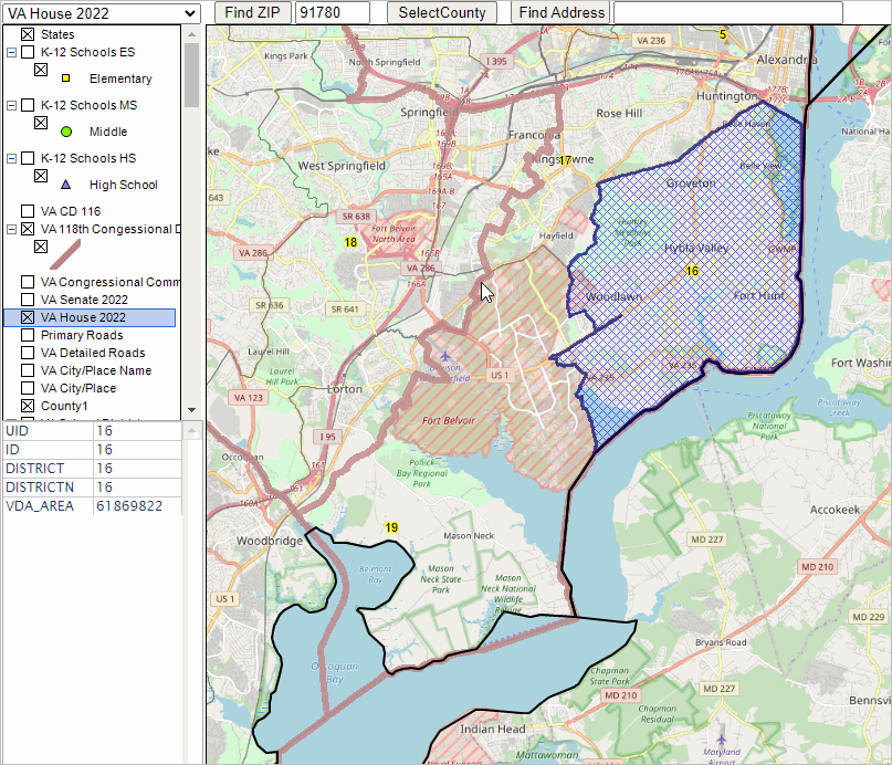 Virginia Senate Districts .. goto top .. 2022 post redistricting .. takes effect in January 2024 session .. graphic shows illustrative view of VA Senate district 34 cross-hatched .. pointer shows boundary of VA 08 and VA 11 118th Congressional Districts .. view developed using VDA Web GIS .. anyone can create this type of view. 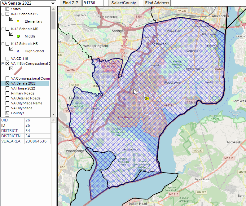 Patterns of Economic Prosperity with VA House Legislative Districts .. goto top .. integrating layers/geographies for improved insights .. a zoom-in focus on Northern Virginia/Fairfax County The following view shows patterns of economic prosperity based on American Community Survey 2020 median household income by block group with an overlay of VA 2024 (fall 2023 elections) House legislative districts. It is easy to visualize how patterns of economic prosperity vary by district. 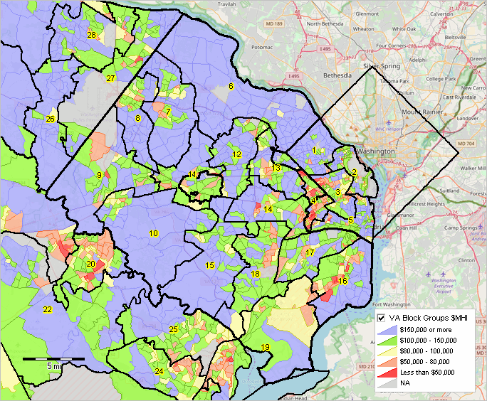 Congressional Communities .. goto top As a resident, constituent, of a congressional district, how do you make your voice heard on key issues affecting you, your household and your local living environment in Congress? Congressional Communities, subdivisions of Congressional Districts, can help Americans better have their voice heard by Congress. Congressional communities are developed by assembling 2020 census blocks and block groups using the ProximityOne CV XE GIS software and state GIS projects. Congressional districts are sub-divided into CCs, sets of contiguous blocks/block groups, that are typically around 40,000 population based on a range of socioeconomic, geopolitical features, geographic and other factors. A set of Census 2020 and American Community Survey demographics are developed for each CC. These demographics help CC stakeholders better understand characteristics and needs of their CCs and other CCs. Unlike census tracts, averaging 4,000 population, CCs nest within CDs and better reflect neighborhood-plus characteristics. Unlike cities, CCs include rural and suburban areas and sub-divide larger cities. The CCs are developed using a combination of blocks and block groups. The graphic below illustrates how blocks and block groups are used to jointly comprise Congressional Community CC20 51-11-018. .. this area is in the general area/vicinity of Ft. Belvoir, VA. .. Adjacent CC boundaries are shown without fill pattern, with black bold boundaries, labeled with CC code. The pointer is at the bold brown boundary between 118th CD VA08 and VA11. .. The red areas are 2020 blocks. .. The orange areas are 2020 block groups (where the BG is entirely within CD 11) BGs are not used in the red/block areas because they overlap into both VA08 and VA11. Splitting the Ft Belvoir area is unavoidable as the 118th CDs cut through it. 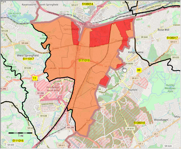 K-12 Schools in Context of Alexandria City .. goto top .. illustrates use markers to shows K-12 school locations 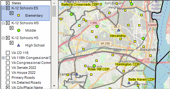 Site Analysis -- Census 2020 Blocks in 1/2-mile Radius Circle .. goto top .. click marker and drag to radius; or cherry pick .. arbitrary location at pointer (south of Pentagon; west of Amazon HQ2 .. selected blocks -- intersecting with 1/2 mile radius circle shown as cross-hatched. .. items selected to aggregate listed in top left listbox. .. aggregate values shown for selected items in middle left listbox (116 blocks). .. list of census block codes shown in lower left listbox. .. there are 19,035 population in these 116 blocks based on Census 2020. 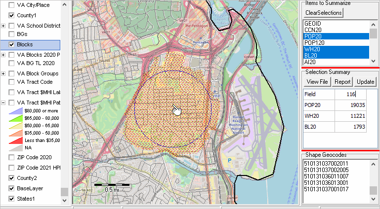 SRDMI Start-up .. goto top The SRDMI resources may be accessed/used by Windows desktop and/or Web version. The SRDMI project fileset has been developed using the CV XE GIS desktop and then ported to the VDA Web GIS for Web access/use. CV XE GIS desktop software • about/usage • run installer .. register for id Install SRDMI GIS project fileset Using VDA Web GIS .. goto top Visual Data Analytics (VDA) Web GIS • about/usage • Start VDA Web GIS: https://vdagis.com Start VDA Web GIS: https://vdagis.com .. see getting started guide .. after login, select the Virginia SRDMI project .. more details below with an example. Using Virginia SRDMI with VDA Web GIS .. goto top .. patterns of median household income (ACS2020) by Census 2020 census tract .. zoom-in to Alexandria, VA showing map/table view .. query geoid like '51510' and mhia20>200000 applied .. Alexandria tracts where median household income is greater than $200,000 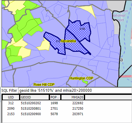 Start VDA: https://vdagis.com Select project: select Virginia SRDMI .. map view appears Change active layer (upper left dropdown) to Tracts Code (select that layer name) Click far right button below map window (Query/Table) .. grid appears below map Click Select Field button below table/grid .. check these items (geoid, pop20, mhia20) and click select, closing form In the SQL Filter above table, key in: geoid like '51510' and mhia20>200000 Click Query button on far right, same row. .. now only 3 tracts show in grid (those meeting the query criteria) Terms of Use .. goto top There is no warranty of any type regarding any aspect of data, software, resources, information described here. Software and/or data provided as described in this section may not be distributed to others. The user of any of these resources, content, is solely responsible for their use. "No fee" users of resources described here are not authorized to use these resources for funded research, any for-fee applications, or provide a service to others. Data provided with the CV XE GIS package are not authorized for use with other GIS software. GIS software is defined as Geographic Information System (GIS) software that can open a shapefile and display that shapefile as a map view. Additional Information .. goto top ProximityOne develops geographic-demographic-economic data and analytical tools and helps organizations knit together and use diverse data in a decision-making and analytical framework. We develop custom demographic/economic estimates and projections, develop geographic and geocoded address files, and assist with impact and geospatial analyses. Wide-ranging organizations use our tools (software, data, methodologies) to analyze their own data integrated with other data. Follow ProximityOne on Twitter at www.twitter.com/proximityone. Contact ProximityOne (888-364-7656) with questions about data covered in this section or to discuss custom estimates, projections or analyses for your areas of interest. |
|
|