
|
|
|
Relating ZIP Codes and Census Tracts -- expanding insights through data analytics
.. what census tracts intersect with a ZIP code of interest? There are many reasons for the underlying the need to convert/equivalence ZIP codes to/from census tracts. Some organizations have to provide census tract codes for addresses/ZIP codes of clients to be in compliance with a law or regulation. Some organizations have addresses/ZIP codes of clients/locations for which they would like to determine the corresponding census tract codes to analyze census tract demographics. This section reviews tools and options for these operations. Start using the ZIP-Tract interactive table below and VDA Web GIS to examine these relationships. Use the ZIP to tract equivalence table below to answer questions like: • Which census tracts intersect with a ZIP code of interest? • Which ZIP code(s) intersect with census tract(s) of interest? • What is the population for a census tract and ZIP code combination? Mapping Relationships & Visual Analysis To view maps of ZIP code and census tract areas, in context of other geography, use the VDA Web GIS with the "ZIPCode-CensusTract" Project. See more details. The following Phoenix/Scottsdale, AZ area view illustrates the intersection of ZIP Code Area 85258 (cross-hatched pattern) with census tracts (black boundaries and geocode labels). Click Find in ZIP button below table to view only these ZIP codes and corresponding tract intersections as shown in map view. See location where ZIP code 85258 intersects census tract 2168.13 (TractGeoID=04013216813). The following view illustrates the intersection of ZIP code 85258 (red boundaries) with census tracts (black boundaries). Note the highway (Pima Freeway) running north-south with pink-red color is part of the topographic layer and not a ZIP code boundary. Using the VDA Web GIS ZIPCode-CensusTract Project The following graphic was generated using the VDA Web GIS with the "ZIPCode-CensusTract" Project. You can use VDA Web GIS to develop a similar view for any ZIP code area or Census tract of interest. See step-by-step details. 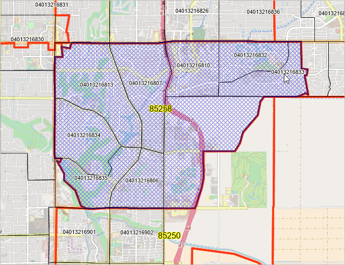
Demographic-Economic Profiles for ZIP Code 85258 and Tract 04013216813 .. do this for any combination of ZIP to ZIP or tract to tract or ZIP to tract. .. using the Demographic Economic Data Explorer -- DEDE Partial view of profile in HTML structure: 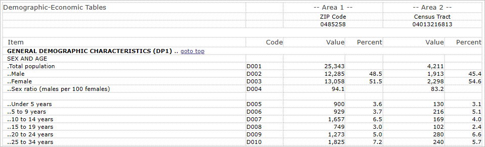 Full 4-part profile for ZIP 85258 - Tract 04013216813 -- Scottsdale, AZ area Using the Interactive Table The interactive equivalence/look-up table below shows a row for each unique combination of a Census 2020 ZIP code area and Census 2020 census tract. The start-up view is sorted on the State-County-Tract column (StCtyTract). View ZIP codes in one state using the State selection button. To locate a ZIP code of interest, either use the Find ZIP query or sort on the ZIP code column and then scroll down the table until the ZIP of interest is located. There are 163,615 rows in the table, each showing a unique combination of a census tract (~85,000 Census 2020 tracts) and ZIP code area (~33,500 Census 2020 ZCTAs). Each row represents an intersection of the specified census tract and ZIP code area and corresponds to the intersecting area. Census 2020 ZIP Code to Census Tract Interactive & Equivalence Table Click column header to sort; click again to sort other direction. Click ShowAll between queries. See related Interactive Tables Main Page Using the Interactive Ranking Table Tract and TractGeoID are variations of the census tract code; Tract is 6 characters, lead zeroes, no decimal. TractGeoID is 11 characters and identifies one tract uniquely among all tracts in the U.S. Find ZIP. Click ShowAll button. Key in a ZIP code and click Find ZIP button (below table) to view the unique combinations of that ZIP code and corresponding census tracts. Find State-County. Click ShowAll button. Key in a StCty code and click Find StCty button (below table) to view all ZIP Codes and census tracts in a specified county. The StCty code is the 5 character code comprised of State FIPS Code (2 characters) and County FIPS Code (3 characters). The default value 04013 is state FIPS code 04 and county FIPS code 013 (Maricopa County, AZ). See list of state-county codes. Find Tract. Click ShowAll button. Key in a StCtyTract code and click Find StCtyTract button (below table) to view the unique combinations of that tract and corresponding ZIP Codes. Use format structure shown in column 3 (StCtyTract code must be 11 characters). Get State and County codes from above description of Find State-County. Tract code must be 6 characters with lead/trailing zeroes as applicable with no dots, no spaces. ProximityOne User Group Join the ProximityOne User Group to keep up-to-date with new developments relating to metros and component geography decision-making information resources. Receive updates and access to tools and resources available only to members. Use this form to join the User Group. Support Using these Resources Learn more about small area demographic-economic characteristics, ZIP code geographic drill-down and related analytical tools. Join us in a Data Analytics Lab Session. There is no fee for these one-hour Web sessions. Each informal session is focused on a specific topic. The open structure also provides for Q&A and discussion of application issues of interest to participants. Additional Information ProximityOne develops geographic-demographic-economic data and analytical tools and helps organizations knit together and use diverse data in a decision-making and analytical framework. We develop custom demographic/economic estimates and projections, develop geographic and geocoded address files, and assist with impact and geospatial analyses. Wide-ranging organizations use our tools (software, data, methodologies) to analyze their own data integrated with other data. Follow ProximityOne on Twitter at www.twitter.com/proximityone. Contact ProximityOne (888-364-7656) with questions about data covered in this section or to discuss custom estimates, projections or analyses for your areas of interest. |
|
|