|
|
|
We live in a data-driven world where public use data, combined with data from other sources, has become vital. New data and tools, with increased availability, are evolving in their usefulness for application to the practical problems in government, business, academia and many facets of our personal lives. Until now, many of these data, and ways to integrate and analyze mixed source data, have been difficult and costly to access and use. The Nevada State & Regional Decision-Making Information (SRDMI) database and GIS Project empowers policy-makers, planners, researchers, analysts to examine wide ranging demographic-economic characteristics and trends. It is one of many Geographic Information System (GIS) projects accessible using the VDA Web GIS. Use these reources to develop wide-ranging reference and analytical views and perform geospatial analyses; see examples below. Add your own data/layers. See about the SRDMI structure and content. Using Nevada SRDMI with VDA Web GIS .. patterns of median household income (ACS2020) by Census 2020 census tract .. zoom-in to Las Vegas, NV showing map/table view .. query geoid like '32003%' and mhia20>150000 applied .. Clark County tracts where median household income is greater than $150,000 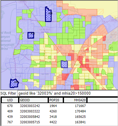 .. see notes on creating this type of view How Users Benefit • use Web-based global GIS resource; nothing to install. • examine K-12 schools in context of neighborhoods. • see how the 118th Congressional Districts differ from the 116th • keep up with new demographics for Congressional Districts & Virginia legislative districts • find your Congressional Community .. view related geography and characteristics. • key in your address; click marker to view your neighborhood characteristics. • examine demographic-economic patterns for geographies not elsewhere available. • more, list to be extended SRDMI Access, Use & Support The SRDMI GIS project may be used with: • CV XE GIS desktop software • Visual Data Analytics (VDA) Web GIS • See Start-up details for each version • Support: join in any/all weekly web sessions .. get answers to questions; discuss applications VDA Web GIS has been developed by Warren Glimpse/ProximityOne/Alexandria, VA USA and Takashi Hamilton/Tsukasa/Osaka, Japan. All that is required to use VDA is a Web browser. Smartphones are supported. Nevada SRDMI GIS Project - Start-up View .. goto top The start-up view shows patterns of economic prosperity based on American Community Survey 2020 average household income (ACS 2020) data by census tract. 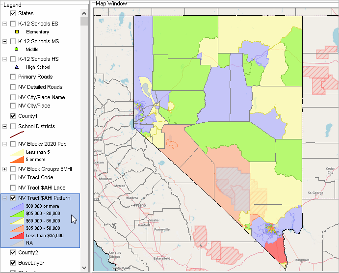 .. click graphic for larger view. See related illustrative graphics below the layer descriptions. Nevada SRDMI GIS Layers .. goto top The layers included in the GIS project are shown in the legend panel in the above graphic and described in more detail below.
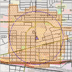
Patterns of $AHI by Tract -- Zoom-in to Clark County .. goto top .. see color patterns by $AHI (average household income) range in legend panel. .. illustrates use of select/identify to to view profile for selected tract (at pointer) 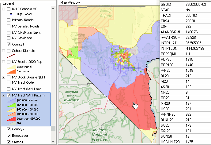 Patterns of $AHI by Tract -- Further Zoom-in to Clark County .. goto top .. illustrates use of labels by tract .. upper label tract code .. lower label $AHI .. illustrates use of detailed roads layer 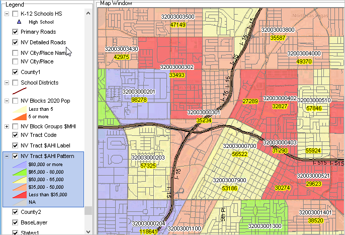 K-12 Schools in Context of $AHI by Tract -- Further Zoom-in to Clark County .. goto top .. illustrates use markers to shows K-12 school locations 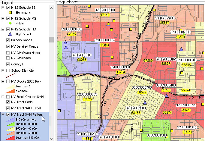 Site Analysis -- Census 2020 Blocks in 1/2-mile Radius Circle .. goto top .. click marker and drag to radius; or cherry pick .. Sparks High School; Sparks, NV blue triangle .. selected blocks -- intersecting with 1/2 mile radius circle shown as cross-hatched. .. items selected to aggregate listed in top left listbox. .. aggregate values shown for selected items in middle left listbox (122 blocks). .. list of census block codes shown in lower left listbox. .. there are 10,816 population in these 122 blocks. 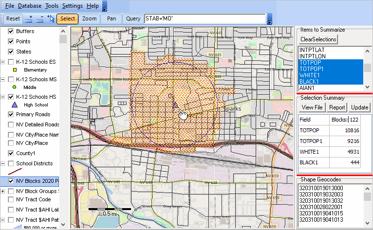 SRDMI CV XE GIS Start-up .. goto top CV XE GIS desktop software • about/usage • run installer .. register for id Visual Data Analytics (VDA) Web GIS • about/usage • Start VDA Web GIS: https://vdagis.com Using Nevada SRDMI with VDA Web GIS .. goto top .. patterns of average household income (ACS2020) by Census 2020 census tract .. zoom-in to Las Vegas, NV showing map/table view .. query geoid like '32003%' and mhia20>150000 applied .. Clark County tracts where median household income is greater than $150,000 Start VDA: https://vdagis.com Select project: select Nevada SRDMI .. map view appears Click far right button below map window (Query/Table) .. grid appears below map Click Select Field button below table/grid .. check these items (geoid, pop20, mhia20) and click select, closing form In the SQL Filter above table, key in: geoid like '32003%' and mhia20>150000 Click Query button on far right, same row. .. now only 4 tracts show in grid Terms of Use .. goto top There is no warranty of any type regarding any aspect of data, software, resources, information described here. The user of any of these resources, content, is solely responsible for their use. "No fee" users of resources described here are not authorized to use these resources for funded research, any for-fee applications, or provide a service to others. Additional Information .. goto top ProximityOne develops geographic-demographic-economic data and analytical tools and helps organizations knit together and use diverse data in a decision-making and analytical framework. We develop custom demographic/economic estimates and projections, develop geographic and geocoded address files, and assist with impact and geospatial analyses. Wide-ranging organizations use our tools (software, data, methodologies) to analyze their own data integrated with other data. Follow ProximityOne on Twitter at www.twitter.com/proximityone. Contact ProximityOne (888-364-7656) with questions about data covered in this section or to discuss custom estimates, projections or analyses for your areas of interest. |
|
|