Comparing ZIP Codes/Census Tracts
In this section, you will learn to find/compare census tracts with ZIP Code areas using iVDA with the "ZIP-Code-Census Tract" project. Here we use ZIP Code Tabulation Areas (ZCTAs) as a proxy for USPS ZIP Codes (using ZCTAs as proxies). See related interactive table.
iVDA is one part of a broader VDA GIS resource framework. See more about VDA GIS.
In the iVDA frame below, the start-up view shows ZCTAs with red boundaries and labels and census tracts with black boundaries and labels. The view is a zoom-in to the ZCTA 91780.
Find a ZIP code based on an address/location; view intersecting census tracts.
.. in the searchbar above the map enter an address or location press enter.
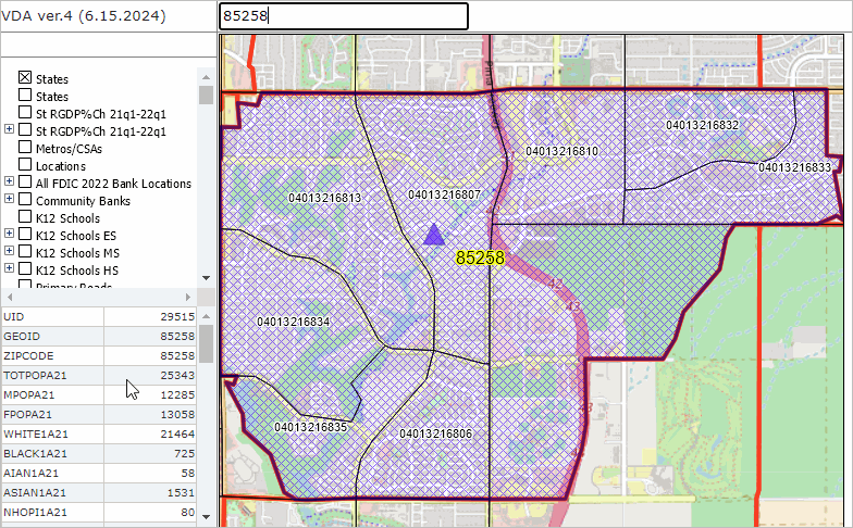
.. this example uses ZIP code 85258 (or use address like 9451 N 84th St, Scottsdale, AZ 85258).
.. the map view zooms to ZIP 85258 (cross hatched) and places a blue triangle at the location.
.. census tracts are shown with black boundaries and labeled with census tract code.
.. a demographic profile for the ZIP code is displayed in the lower left panel.
.. here you can examine many demographic subject matter items for that ZIP code.
Visual Data Analytics Web GIS
iVDA is presented below in an interactive mapping window .. watch video
Below is a static graphic example of using iVDA as described above for ZIP 85258 (Scottsdale, AZ).

