CVGIS Project

Contents
The "CVGIS Project" described in this section is the GIS project installed with the CVGIS installer.
| • | opened when CVGIS starts. |
| • | the default path/file name for this project file is c:\cvgis\1\cvgis.gis. |
This section reviews the structure of the CVGIS project.
| • | provides illustrative views of what you can do with any CVGIS version |
| • | see topics list below |
See related sections:
| • | Table of Contents and CVGIS feature overview |
| • | Select from other wide-ranging ready-to-use GIS projects/filesets |
.. see mapping statistical data
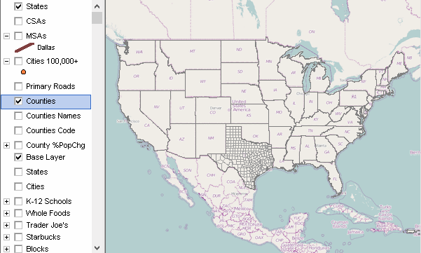
CVGIS Start-up View using the default CVGIS project

The above CVGIS view shows 10 layers checked in the legend panel at left of the map window.
| • | a layer check box must be checked to appear in the map window. |
| • | layers appear in the map window as ordered in the legend panel. |
| • | all layers in the CVGIS project are listed in the table below. |
| • | with CVGIS running, use the legend scroll bar to scroll down and view all layers in the project |
Narrative Description of the CVGIS Project
The CVGIS project includes a set of shapefiles, with varying types of geography and scope of subject matter, focused on the Dallas, TX area.
| Seq | Name | Layer Source File | Notes |
| 1 | States1 | cb_2015_us_state_500k.shp | U.S. by State States |
| 2 | CSAs | cb_2015_us_csa_500k_48.shp | Combined Statistical Areas - Texas |
| 3 | CBSAs TX | cb_2015_us_cbsa_500k_48.shp | Core-Based Statistical Areas Texas |
| 4 | Cities/Places TX | places2015pts_48.shp | Cities/Places - Texas |
| 5 | Primary Roads | tl_2016_us_primaryroads.shp | Primary Roads -- U.S. |
| 6 | Roads Dallas County | c:\cvgis\1\tl_2016_48113_edges.shp | Edges/Roads -- Dallas County, TX |
| 7 | Counties1 | cb_2015_us_county_500k_48.shp | Counties -- Texas |
| 8 | Counties Names | cb_2015_us_county_500k_48.shp | Counties -- Texas -- Names |
| 9 | Counties Code | cb_2015_us_county_500k_48.shp | Counties -- Texas -- Code |
| 10 | Counties2 | cb_2015_us_county_500k_48.shp | Counties -- Texas -- %PopChg |
| 11 | OSM | mapquest openstreetmaps tiles.ttkwp | OpenStreetMaps Tiling Layer |
| 12 | States2 | cb_2015_us_state_500k.shp | U.S. by State |
| 13 | Places TX | cb_2015_48_place_500k.shp | Cities/Places -- Texas -- polygon |
| 14 | K12 Schools | sch1415_48.SHP | K-12 Schools -- Texas -- points |
| 15 | Whole Foods | wflist_tx.shp | Whole Foods -- Texas -- points |
| 16 | Trader Joes | tjlist_tx.shp | Trader Joe's -- Texas -- points |
| 17 | Starbucks | starbucks_dallas.shp | Starbucks -- Texas -- points |
| 18 | Blocks 48113 | tl_2016_48_tabblock10_113.shp | Census 2010 Blocks -- Texas -- polygons |
| 19 | Blockgroups | tl_2016_48_bg_113.shp | Census 2010 BlockGroups -- Texas -- polygons |
| 20 | Tracts | cb_2014_us_tracts_500k_acs1014_48.shp | Census 2010 Census Tracts -- Texas -- polygons |
| 21 | ZIP Code Areas | tl_2014_us_zcta510_dallasarea.shp | ZIP Code Areas -- Texas -- polygons |
| 22 | School Districts | us_sd_201314_2015_48.SHP | School Districts -- Texas -- polygons |
| 23 | PUMA 2010 | puma2010gz_48.SHP | Public Use Microdata Areas -- Texas -- polygons |
| 24 | CD 114 | cb_2015_us_cd114_500k_acs2015_48.SHP | 114th Congressional Districts -- Texas -- polygons |
| 25 | World by Country | world2016_base.shp | World by Country |
Topics list for views shown below
| • | Sequence of Views Illustrating Small Area Geography Drill-down |
The following views have been developed to illustrate how this project can be used.
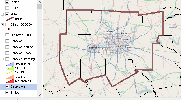
Reference View of a Metro Area
Unchecking three county layers (compare to default view at top)
Checking on Base Layer
Reference View of a Metro Area - Adding a City
As above, shifting cities layer up and checking cities layer on
A query is placed on the city layer to show only Dallas city with blue cross-diagonal pattern.

Sequence of Views Illustrating Small Area Geography Drill-down
- roads & business locations
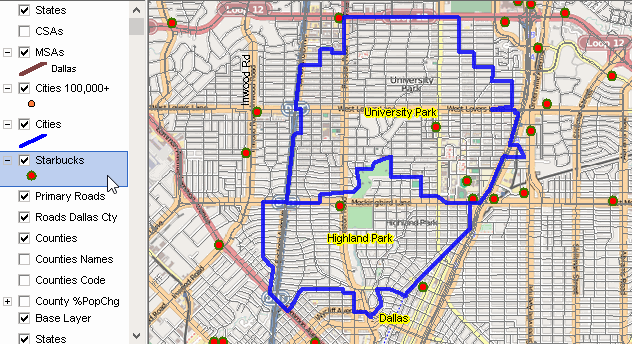
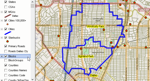
Zoom-in to University Park/Highland Park (blue bold) within Dallas County
Illustrates shifting (sliding layers in legend panel) layers
Checking on Roads and Starbucks
Sequence of Views Illustrating Small Area Geography Drill-down
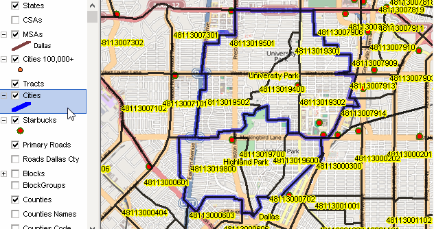
- census tracts
Census tracts have bold black boundaries and show census tract code
Sequence of Views Illustrating Small Area Geography Drill-down
- block groups
Block groups have black boundaries

Sequence of Views Illustrating Small Area Geography Drill-down
- census blocks
Census blocks have gray boundaries
Sequence of Views Illustrating Small Area Geography Drill-down
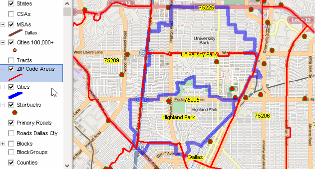
- ZIP Code areas
ZIP code areas have red boundaries and labeled with ZIP code.
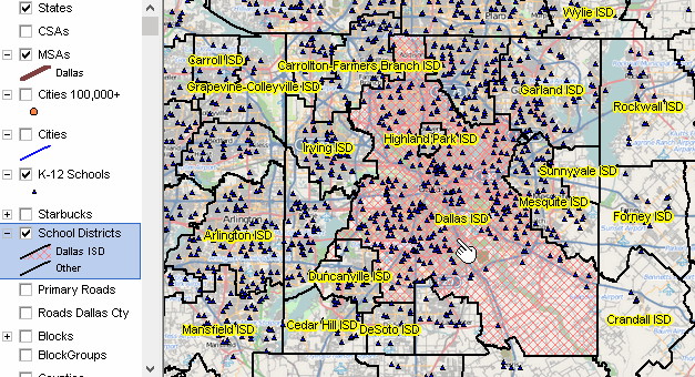
Dallas County area school districts (black boundaries) & schools (blue triangle markers)
Dallas ISD shown with red cross-hatch pattern
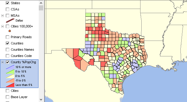
Zoom out to region encompassing Texas
Texas by county thematic map
State by Census Tract Thematic Map
View as above, sliding the $MHI by tract layer up and checking it on
Texas by census tract thematic pattern map

Zoom out to US 48 state view
Base Layer checked on
Texas by County layer checked on
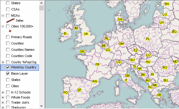
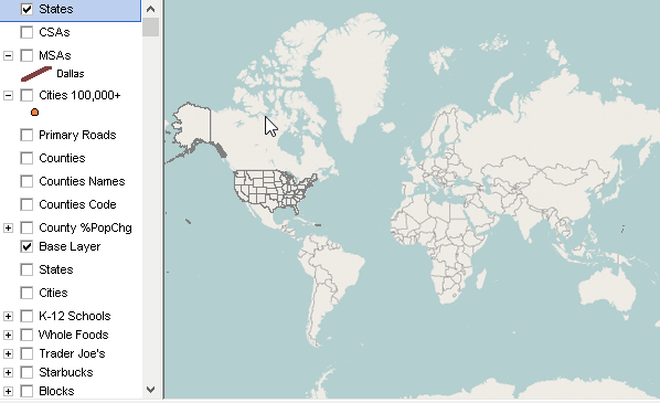
As above, zoom out to world view.
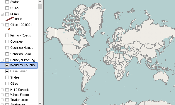
As above, World by country layer shifted up.
Shows country boundaries.
As above, zoom into Europe.
World by Country country code used as label