ACS2017 Summary File by Census Tract

Contents
What is the residential demand for home heating fuel by type in the Wheeling, WV MSA?
How is the demand distributed by type by census tract?
This section shows how to develop and view/use data from the 2017 American Community Summary data at the census tract level to get answers to these questions.
.. generalizable to any metro (or other summary level)
.. generalizable to any demographic topic
In the Wheeling metro overall, the number of housing units by type of heating fuel is shown via this link:
https://factfinder.census.gov/bkmk/table/1.0/en/ACS/17_5YR/B25117/310M300US48540
To map/geospatially analyze these data, proceed as follows ...
A summary of the steps:
1. access the required subject matter data.
1.1. determine the list of subject matter items
1.2. determine the list of census tract codes
1.3. use CV XE GIS APIGateway with data from 1.1. and 1.2. to create the MSA by tract data file
1.4. optionally use the data from 1.3. with a program like Excel, stopping here.
Optionally proceed to create map to visually, geospatially, analyze the data.
2. use CV XE GIS Database>dBMerge to merge the data in 1.3. into the exist tract shapefile.
3. Use the CV XE GIS with associated GIS project to view/analyze the data.
--------------------
1.1. determine the list of subject matter items
Subject Matter: Selected items from Table B25117:
See other items/tables:
http://proximityone.com/acs2017/ACS2017_Table_Shells.xls
There are 33,923 populated data cells listed in the above table. Not all items are available for all geographies.
The table of interest from the above file:
TENURE BY HOUSE HEATING FUEL
Universe: Occupied housing units
B25117_001 Total units
B25117_002 Owner occupied units
B25117_003 Utility gas
B25117_004 Bottled, tank, or LP gas
B25117_005 Electricity
B25117_006 Fuel oil, kerosene, etc.
B25117_007 Coal or coke
B25117_008 Wood
B25117_009 Solar energy
B25117_010 Other fuel
B25117_011 No fuel used
B25117_012 Renter occupied units
B25117_013 Utility gas
B25117_014 Bottled, tank, or LP gas
B25117_015 Electricity
B25117_016 Fuel oil, kerosene, etc.
B25117_017 Coal or coke
B25117_018 Wood
B25117_019 Solar energy
B25117_020 Other fuel
B25117_021 No fuel used
Create subject matter file:
save following item codes to file c:\cvxe\1\api_items_acs2017_b25117.txt
B25117_001E Total units
B25117_002E Owner occupied units
B25117_003E Utility gas
B25117_004E Bottled, tank, or LP gas
B25117_005E Electricity
B25117_006E Fuel oil, kerosene, etc.
B25117_007E Coal or coke
B25117_008E Wood
B25117_009E Solar energy
B25117_010E Other fuel
B25117_011E No fuel used
B25117_012E Renter occupied units
B25117_013E Utility gas
B25117_014E Bottled, tank, or LP gas
B25117_015E Electricity
B25117_016E Fuel oil, kerosene, etc.
B25117_017E Coal or coke
B25117_018E Wood
B25117_019E Solar energy
B25117_020E Other fuel
B25117_021E No fuel used
1.2. determine the list of census tract codes
Create Geographies (tracts) file
Use c:\cvxe\1\api_geo_tracts73056.txt
Select tracts in three counties (determine county list from metro S&O report):
39013 Belmont County
54051 Marshall County
54069 Ohio County
save following tract codes to file c:\cvxe\1\api_geo_tracts_wheeling.txt
39013010100
39013010200
39013010300
39013010600
39013010700
39013010802
39013010900
39013011000
39013011200
39013011300
39013011400
39013011500
39013011600
39013011700
39013011900
39013012000
39013012100
39013012200
39013012300
39013012400
54051020200
54051020500
54051020601
54051020702
54051020800
54051020900
54051021000
54051021100
54051021300
54069000200
54069000300
54069000400
54069000500
54069000600
54069000700
54069001300
54069001400
54069001500
54069001600
54069001700
54069001800
54069001901
54069002000
54069002100
54069002200
54069002600
54069002700
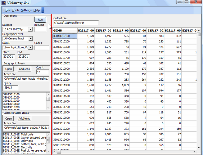
1.3. use CV XE GIS APIGateway with data from 1.1. and 1.2. to create the MSA by tract data file
Start File>APIGateway:
Open the Geographic Areas file
Open the Subject Matter file
Select the Geography Level as Census Tract
Select the Datasets as ACS 2017/5yr
Empty the RecLimit edit box
Click the Run button; processing takes a few minutes.
The file c:\cvxe\1\apinewfile.dbf is generated.
The new file has a row for each tract and column for each subject matter item.
Close the form when processing complete.
The grid shows tracts as rows and subject matter items as columns.
Column headers show the item code/field name.
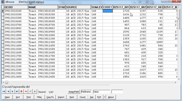
Extracted file may be viewed in CV XE GIS Database>DBrowse (file appears similar in Excel):
2. use CV XE GIS Database>dBMerge to merge the data in 1.3. into the exist tract shapefile.
Merge into shapefile dbf: CB_2017_US_TRACT_500K_ACS2017.dbf
(files cannot be in use)
or cb_2017_tracts_wheeling.dbf (three county variation):
geoid like '39013%' or geoid like '54069%' or geoid like '54051%'
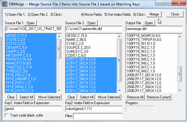
DBMerge form closes when complete.
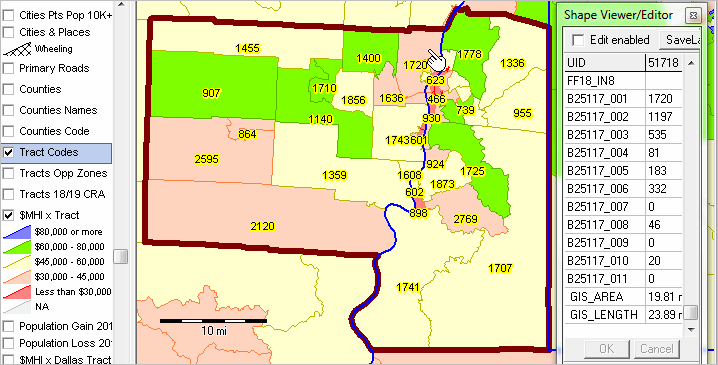
Open the GIS project with the shapefile that was updated.
Use Layer Editor to label tracts with item B25117_001 (total housing units)
See in view below ... pointer in tract labeled with 1720 housing units.
See ShapeViewer profile to right of map.
There are 1,127 occupied units (households).
Of the 1,197 owner occupied units, 535 are estimated to use utility gas for heating.
For more information about using the above tools and operations, join us in a weekly Data Analytics Web Session.
See more at http://proximityone.com/data_analytics_websessions.htm