Examining Neighborhood Demographics |

|

|

|

|

|
||
Examining Neighborhood Demographics |
|
|
|

|

|

|
Examining Neighborhood Demographics |
|
|
|
|
|
||
Examining Neighborhood Demographics |
|
|
|
|
|
|
|
|
||
This section illustrates use of DDA to examine characteristics of census blocks and census tracts in the vicinity of an address. This type of application is often needed in real estate related analyses, site location, market studies and neighborhood comparisons. Geographic focus of the application is in the Scottsdale area of the Phoenix, AZ metro using data from Census 2010 Summary File 1 and TIGER shapefiles. The same set of steps and analytical capabilities apply to anywhere in the U.S.
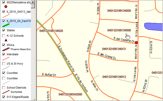
In this application, a hypothetical location of interest is located in the 8000 block of E. del Cadena Drive in Scottsdale, AZ.
Map view of street/block/location
|
Map view of larger area with census tract boundaries
|
The address is entered here to determine geographic codes of interest.
Start DDA
•Select Arizona (AZ) as the state to process (upper left "State" combobox).
Downloading Complete 2010 Census Summary File 1 (SF1) Data
•Use File>Get Census SF1 to download the Arizona SF1. (optionally skip this step using the DVD as data source)
•Use File>UnZip to expand all or selected SF1 segments.
Creating Complete or Partial SF1 Database
•Use Tools>Create Census 2010 SF1 DBFs
... each of the SF1 segments is created as a dbase file.
... after conversion, any SF1 segment can be accessed with File>Open DBF.
Extracting Data from the Relational SF1 Database into Flat File
•Use the pre-existing "itemlist_blockdp.txt" file to select desired subject matter fields.
•Set output file name to "extract_04013blk.dbf".
•The Extract Query is set to:
(sumlev='140' .or. sumlev='101') .and. county='013' .and. substr(tract,1,4)='2168'
140 -- census tract or 101 -- census block
and in Maricopa County (013)
and any census tract starting with 2168
•Click Go button to proceed.
Mapping Applications
The next steps illustrate steps to integrate the new demographics into shapefiles for mapping.
However, some applications may not involve mapping.
Your SF1 processing might end here.
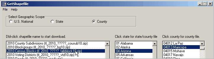
Downloading Shapefiles
•Use File>Get Shapefile to download the Maricopa County, AZ census blocks shapefile.
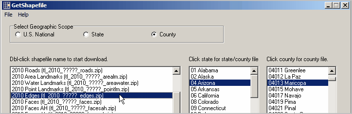
•Use File>Get Shapefile to download the Maricopa County, AZ edges/roads shapefile.
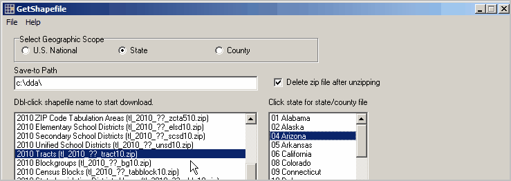
•Use File>Get Shapefile to download the Arizona Census 2010 census tracts shapefile.
•In the next step, extracted SF1 data are integrated with the shapefile dbf (1 at block level, 2 at tract level).
Integrating Data to TIGER/Line Shapefiles
•Start Tools>DBMerge and select the county by block shapefile dbf as File 1 and extract dbf as File 2:
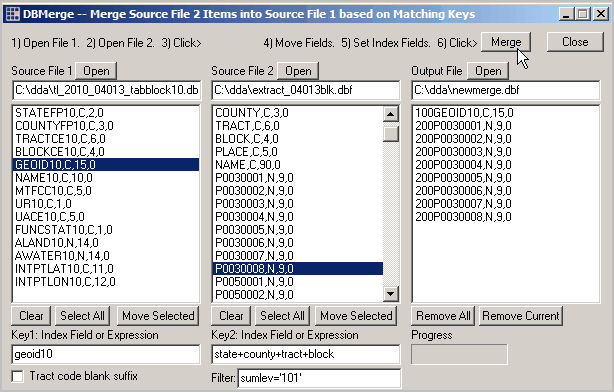
72,729 census blocks (Maricopa County) are processed
•Start Tools>DBMerge and select the Census 2010 state by census tracts shapefile dbf as File 1 and extract dbf as File 2:
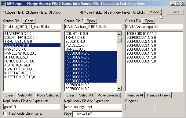
1,526 census tracts (Arizona) are processed.
Pattern Analysis; Creating Thematic Maps
The Kansas Census 2010 school district shapefile with integrated SF1 data is opened using the CommunityViewer GIS (CV) software.
Mapping capabilities are not included with DDA.
Use CV or other mapping software to create a thematic map.
A thematic map is created showing the percent Hispanic population by school district shown below.
The CV identify tool is used to show a profile for a selected school district (see pointer).