|
Roads/Streets |
  
|
|
Roads/Streets |
|
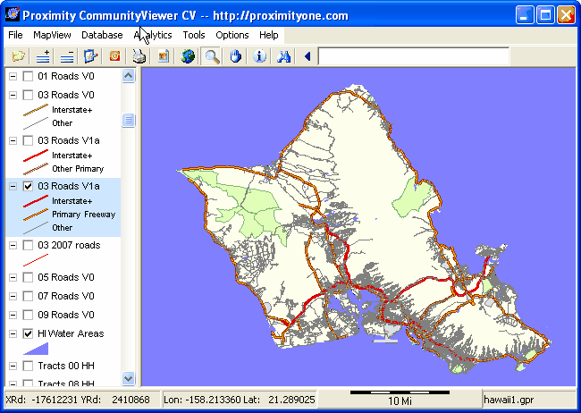
Roads are an integral part of most mapping applications and visually based/geospatial analyses. Often analyses need extensive flexibility regarding what types of roads are displayed, labeled and used. Roads/streets used in this document are variations to the Census Bureau "Edges" MAF/TIGER TIGER/Line shapefiles. The MTAIP updated TIGER/Line shapefiles became available for all states/counties in December 2008. Before MTAIP completion of these files for Hawaii, the poor quality of the roads data rendered the streets shapefiles generated from TIGER/Line files of limited value. Now things are different, but require updating and extension.
While high quality streets shapefiles are available from other sources, there are many considerations that make use of road/streets derived from the TIGER/Line edges shapefiles important.
| • | Only road/street segments derived from these files are coded so that pertinent geocodes on the left and right side of each street segment can be accessed. |
| • | Only road/street segments derived from these files make it feasible to geocode addresses and accurately assign census block (or higher level aggregate statistical area) codes to an address. Since many addresses may be on a street segment that is a block or census tract boundary, this can be critical. |
| • | Only road/street segments derived from these files will exactly match boundaries of statistical/political geography such as census blocks (hence anything based upon census blocks), census tracts, places, school districts, congressional districts, to name a few. |
| • | Roads/streets shapefiles developed by others vary from county to county as to field coverage and definition, date of update, quality, geographic scope of coverage, access and in other ways. |
The TIGER/Line edges shapefile includes all lines segments used in any of the TIGER/Line shapefiles. In the hawaii1.gpr project fileset used here, each county edge shapefile appears with the legend layer name of the for "?? Roads V0" where ?? is the Hawaii county FIPS code. "V0" indicates Version 0 or the original TIGER/Lines edges shapefile. The following graphic shows these layer names in the legend. The V1a (Version 1a) is an updated version of the Version 0 file. Edge file street features are updated by Proximity. Street features are based on the MTFCC code used in the TIGER/Line shapefiles. The next section provides more detail.
Page url: http://proximityone.com/hidmi/guide/index.html?roads.htm