Intersect
Tools>Intersect intersects one shapefile (A) with another shapefile (B) and creates a new shapefile with shapes for any intersecting area from A and B.
Availability
An option to Level 3
Usage
Start Intersect from the Tools menu .. Tools>Intersect
Related Information and Example
The objective in this example is to attach the congressional district code to each school.
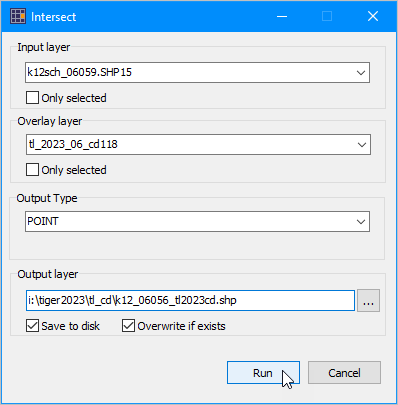
The following graphic shows the start-up view of the Intersect form.
In this example the k12sch_06059.shp15 is the name of the school points layer in the active project.
tl_2023_06_cd118 is the name of the TIGER sourced TL 118 congressional district polygon shapefile.
In this example. click tl_2023_06_cd118 to download the California CD118 shapefile.
The schools shapefile used in this example is located in the VDAGIS Base project.
.. use your own point shapefile. For this to produce useful results, the points would need to be in California.
When using Intersect in this manner, it is important to use the TL version of the shapefile rather than the smoothed version (CB) of the shapefile.
Intersect can assign geocodes for any type of point/polygon situation.
The following graphic also shows the output will be a point shapefile.
The output file will be the point shapefile name i:\tiger2023\tl_cd\k12_06056_tl2023cd.shp.
.. in general use some filename meaningful to you in a folder useful to you.
Click Save to disk checkbox and then click Run button.
Processing might take a few minutes or hours depending on size factors of the input files.

Output
With the Intersect operation completed, close the Intersect form.
.. optionally the entire project could be closed.
.. the new shapefile has been saved permanently to disk.
.. it can be used with any GIS project.
But first, these additional steps are reviewed.
In this example, the shapefile generated is named k12_06056_tl2023cd.shp.
The shapefile is automatically added to the project and is shown as the top layer in the legend panel.
The new shapefile contains all fields from the input file followed by the fields from the overlay file.
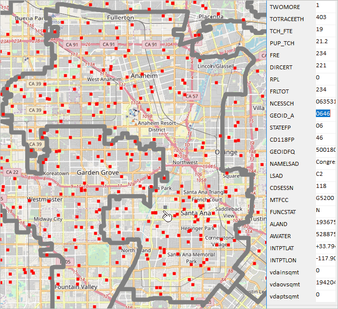
In the graphic below the schools in the output file are shown as red markers.
.. congressional districts (CD) are shown with the gray bold boundary. The zoom-in is to California CD 47.
The identify tool is used to click-on/select the school near the pointer. The profile appears as shown in the graphic.
.. this view of the profile shows a portion of the school/shape view.
.. note that GEOID_A has the value "0646" .. this school is in and has been assigned to this CD.
See more about uses of the new intersected file below.

Intersect on an input layer and overlay layer producing a new shapefile that is added as a layer upon completion.
The new file k12_06056_tl2023cd.dbf (note dbf extension) could be modified using database>dbtools>create/modify.
.. all of the fields added from the overlay file could be deleted -- except the (in this case) the GEOID_A field.
