

Public Use Microdata Areas |

|

|

|

|

|
||
Public Use Microdata Areas |
|
|
|
|

|

|
Public Use Microdata Areas |
|
|
|
|
|
||
Public Use Microdata Areas |
|
|
|
|
|
|
|
|
||
Related sections:
http://proximityone.com/puma2010.htm
http://proximityone.com/puma/puma2010ks.htm (sample view)
Public Use Microdata Areas (PUMAs) provide most detailed U.S. wall-to-wall geography (2,378 areas) for which current year demographic-economic data are available and annually updated. Use the related Public Use Microdata Sample (PUMS) data to develop custom-defined subject matter estimates for one or all PUMAs.
PUMA Summary Statistic Data
2010 vintage PUMA summary statistic data, based on the ACS 2012 1-year estimates, may be accessed via these interactive tables:
• General Demographics -- http://proximityone.com/puma12dp1.htm
• Social Characteristics -- http://proximityone.com/puma12dp2.htm
• Economic Characteristics -- http://proximityone.com/puma12dp3.htm
• Housing Characteristics -- http://proximityone.com/puma12dp4.htm
PUMA Microdata
Public Use Microdata Sample (PUMS) files provide a way to develop custom estimates of demographic summary statistics for PUMAs, states and the U.S. The American Community Survey (ACS) PUMS files are comprised of samples of individual respondent person and housing unit records. The ACS PUMS files are released annually providing a means to develop similar custom estimates with annual updates.
PUMA10 GIS Project http://proximityone.com/dmd/2/puma10.zip
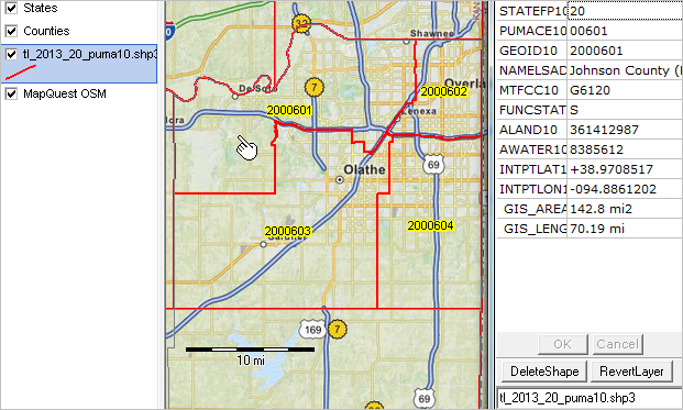
tl_2013_20_puma10 -- illustrative view
tl_2013_st_puma10 dbf attributes
| Public Use Microdata Area (PUMA) Shapefile (state-based) Record Layout | |||
| tl_2013_[state FIPS]_puma10.shp | |||
| Field | Length | Type | Description |
| STATEFP10 | 2 | String | 2010 Census state FIPS code |
| PUMACE10 | 5 | String | 2010 Census Public Use Microdata Area code |
| GEOID10 | 7 | String | 2010 Census nation-based Public Use Microdata Area code; a concatenation of 2010 Census state FIPS code and Public Use Microdata Area code |
| NAMELSAD10 | 100 | String | 2010 Census translated legal/statistical area description code and Public Use Microdata Area name |
| MTFCC10 | 5 | String | MAF/TIGER feature class code |
| FUNCSTAT10 | 1 | String | 2010 Census functional status |
| ALAND10 | 14 | Number | 2010 Census land area |
| AWATER10 | 14 | Number | 2010 Census water area |
| INTPTLAT10 | 11 | String | 2010 Census latitude of the internal point |
| INTPTLON10 | 12 | String | 2010 Census longitude of the internal point |
