Examining Congressional District & Congressional Community GeoDemographics

Contents
In this section, you will learn to examine congressional district (CD) and congressional community (CC) geodemographics of interest using iVDA with the "Base" project. We will focus initially on Arizona Congressional District 01 and access to healthcare resource in context of CDs and CCs. What changes in CMS rules might affect healthcare access in rural areas and areas with high dependency ratios? Healthcare access is used here, but many other topics could be examined. See related congressional district interactive table.
iVDA is one part of a broader VDA GIS resource framework. See more about VDA GIS.
In the iVDA frame below, key in an address or location in the searchbar and press enter.
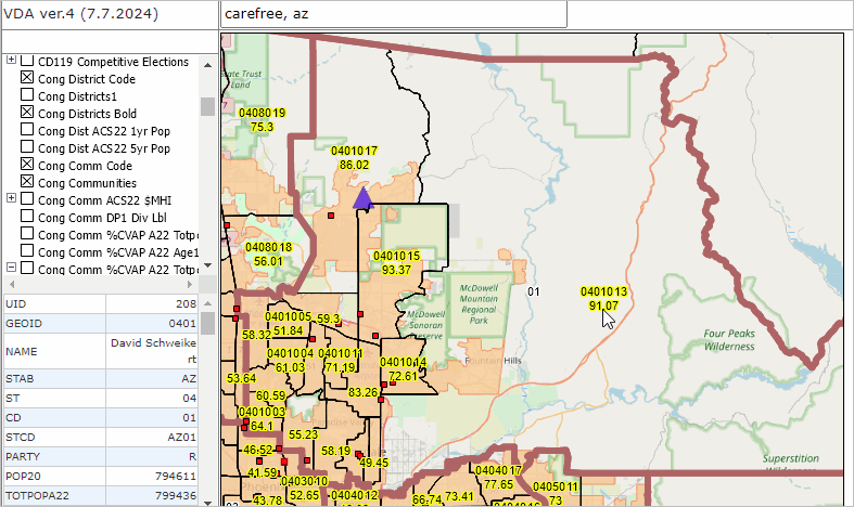
.. enter "Carefree, AZ" not case sensitive, no quotes.
.. the mapview zooms-in to AZ CD 01, cross-hatched, and places a blue triangle at the location.
.. an AZ CD 01 demographic profile is shown in the lower left panel.
.. optionally download the profile (clipboard button).
.. perform this operation for any address or location, but first we will examine more detail.
In the Legend Panel at the left of the Map Window, check-on these layers:
.. Cong District Code
.. Cong Districts Bold
.. Cong Comm Code
.. Cong Communities
.. Cong Comm DP1 Dep Ratio
.. Urban Areas
.. Hospitals
The view should now appear similar to the static view shown below the iVDA iframe.
Use a different address/location. Explore an area of interest.
Visual Data Analytics Web GIS
iVDA is presented below in an interactive mapping window .. watch video
Below is a static graphic example of using iVDA as described above.
.. the marker based on the searchbar address or location is shown by the blue marker.
.. AZ CD 01 is shown by the bold brown boundary
.. congressional communities are shown by black boundaries
- CCs are labeled with CC code (upper)
- CCs are labeled with the dependency ratio (lower)
- see at pointer the CC is 0401013 with dependency ratio of 91.07
.. urban areas are shown with salmon color fill pattern
.. hospitals, registered with CMS Medicare are shown with red markers
- there are no hospitals in the rural area of AZ CD 01
Explore more detail?
.. in the legend panel check on the "Tracts DP1 Dep Ratio" and + toggle to show legend color/values
- the map view refreshes with showing patterns of the dependency ratio by census tract