|
|
|
Using GeoDemographics for Strategic Planning & Analysis
Improving educational opportunities and outcomes ... join us in the one-day, computer hands-on workshop "Using GeoDemographics for Strategic Planning and Analysis" on March 17, 2011, Oneida, NY. This session is a part of the Mohawk Regional Information Center and ProximityOne partnership program, see related program brochure. Focus
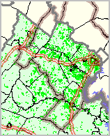
Target Audience The audience includes school and school district leadership, stakeholders, analysts and planners. Overview Participants will learn about: • Review of new GeoDemographic data resources • What the new Census 2010 & American Community Survey can tell us • How your school district community has changed since 2000 • Using the Census 2010 TIGER/Line geographic data • Examining student data in context of related demographics • Assessing demographic composition of attendance zones • How to visualize these data for your school district • How to integrate these data into your strategic planning Dates/Locations/Times March 17th, Costello Center, Oneida NY, 9:00am - 3:00pm Presenter Warren Glimpse, ProximityOne Agenda 9:00am - 10:00am What Census 2010 and the American Community Survey are Telling Us • Scope • Importance • Regional Impact: Counties, Cities, Your District • Conveying this information to your stakeholders 10:00am - 12:00pm Accessing and Using the Data • Census 2000, Census 2010, ACS, GeoBase • Live computer-based examples; how-to Integration via MORIC/ProximityOne & CommunityViewer • Live computer-based examples; how-to • Turning data into action Getting Basic Data for Your District/Community • Initial start-up of computer applicationsv • Interpreting the basic data 12:00pm - 1:00pm Working lunch (Optional additional laptop time) 1:00pm - 3:00pm Examining the Data for Your District/Community • Hands-on time • Using CommunityViewer with district data • Geographic drill down: census blocks; census tracts; attendance zones • Tabular & spreadsheet formats • Mapping applications and pattern analysis • Integrating your data • Students, attendance zones/buildings, tax parcels • Next Steps Resources and Tools We review knitting together related but separate data resources and tools to examine/analyze your geography and demographics. We review how to link these resources with your data to enhance strategic planning and analysis. Census 2010 Census 2010 data still provide very small area demographic data (census block) but for a much more limited set of subject matter compared to Census 2000. Use of the “short form” only results in basic demographics: age, gender, race-ethnicity, household and family composition, and basic housing unit structure and occupancy characteristics. The first census block level data were released by Census in February 2011. Learn exactly what is available, how to access it and how to integrate the data for analysis and decisionmaking. American Community Survey Richer demographics, such as data on educational attainment, income, employment by occupation and industry and more for small area geography are now available through the annual American Community Survey (ACS). New small area demographic data were released in December 2010, providing the first richer demographic updates since Census 2000 for all school districts. ACS data are now flowing on an annual basis; updates annually rather than every 10 years. Learn more about accessing and using these data and how to knit them together with Census 2010 data and your data. GeoBase & Census 2010 TIGER/Line geographic database The Census 2010 TIGER/Line shapefiles, released in January 2011, provide the geography boundary data for statistical (e.g., census blocks, tracts, etc.) and political (e.g., cities, towns, school districts, legislative districts, etc.) tabulation areas – and much more. The boundary shapefiles, water and other area feature boundary files, together with road and linear segment data/shapefiles and point shapefiles, help you bring the data to life in the context of Geographic Information System (GIS) applications. Use the intersection to intersection road segments, with geocodes and address ranges on right-left sides, to help with logistical analyses – even independent of th demographic data. CommunityViewer GIS and Analysis The three data resources above have limited value when accessed independently and in a tabular manner. Analysis of data for strategic planning requires knitting these data together, with your data, in ways that support holistic uses of the data – seeing the roads and water, cities, in context with demographic pattern views conveyed by a thematic maps of your attendance zones. The ProximityOne CommunityViewer GIS is a software tool that brings these data together for flexible, wide-ranging analysis. Registration To register, please contact: Phone: 315-361-2700 Email: helpdesk@moric.org Web: www.modelschools.org/msponline About the Presenter Warren Glimpse is an econometrician and founder of ProximityOne. While with the Census Bureau, he developed the State Data Census Program to facilitate access to Census-sourced geographic, demographic and economic data. Glimpse is developer of the CommunityViewer software and many other desktop and web-based data access, integration and analysis tools that facilitate use of the decennial census, ACS and TIGER/Line data with other wide-ranging data in applications such as pattern/trend analysis, geospatial processing and location-based operations. He developed the Columbia, MD GBF/DIME file used as the prototype for the Census Bureau TIGER/Line program. Glimpse worked with hundreds of government agencies on the Census 2010 LUCA program to improve the coverage and content of the TIGER/ Line files and quality and coverage of Census 2010. He is a pioneer in working with school districts to develop and maintain school district decision-making information resources to facilitate strategic planning and analysis. Additional Information Proximity develops geographic-demographic-economic data and analytical tools and helps organizations knit together and use diverse data in a decision-making and analytical framework. We develop custom demographic/economic estimates and projections, develop geographic and geocoded address files, and assist with impact and geospatial analyses. Wide-ranging organizations use our tools (software, data, methodologies) to analyze their own data integrated with other data. Contact Proximity (888-364-7656) with questions about data covered in this section or to discuss custom estimates, projections or analyses for your areas of interest. | ||||||||
|
|