|
Edge2Street |
  
|
| Show/Hide Hidden Text |
|
Edge2Street |
|
| Show/Hide Hidden Text |
The Proximity Edge2Street tool converts a TIGER/Line edge shapefile to a roads/streets shapefile. These road/street segments are inclusive of all types of roads from Interstate to neighborhood streets to dirt roads. The Edge2Street tool is available both as a standalone program and as an integrated CommunityViewer feature.
While the Census Bureau TIGER/Line shapefiles include shapefiles for many types of geography, there is not a roads/streets shapefile structured in a manner familiar to many users. To accommodate traditional methods of address geocoding and related applications using street segments, the Edge2Street operation is used. The TIGER/Line edge shapefile (or all lines) is the starting point to develop the streets shapefile.
Requirements to use Edge2Street operation
Edge2Street operates on a single county TIGER/Line edge shapefile.
Three Census Bureau sourced files are required:
| • | Edge or All Lines TIGER/Line shapefile (EDGE -- shapefile) |
| • | Topological Faces Relationship File (FACES -- "associated database file") |
| • | Address Ranges Relationship File (ADDR -- "associated database file") |
Running the Edge2Street Operation
To use the Edge2Street operation, open a CV project that includes minimally the county EDGES shapefile. In the Legend panel, click the EDGES layer (making it the active layer) that is shapefile to be used to create the streets shapefile. Click Tools>Edge2Street and the Edge2Street form appears as shown below.
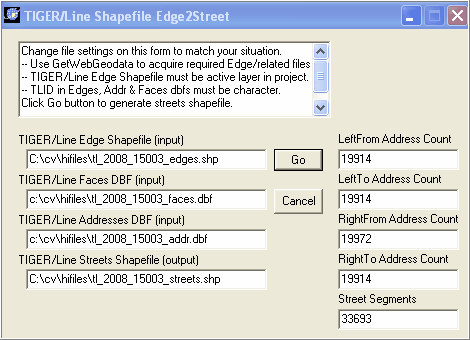
The "associated database files" must exist as specified in the form. Specify the full path and name of the streets shapefile to be created. The streets shapefile must not be in use by any application. If the streets shapefile exists, it will be replaced in this operation.
When ready, click the Go button. The streets shapefile is created. The streets shapefile includes only those line segments from the EDGES shapefile that are attributed as streets and includes all of the fields contained in the original EDGES shapefile dbf. In addition, the new fields are added to the dbf record and populated using the "associated database files."
In the graphic shown above, post-processing values in the right section are counts of segments found containing non-blank addresses. In summary, there are 33,693 road/street segments. 19,914 of these segments contained a non-blank left-side from address. Many road segments (such as Interstate) would not be expected to have from-to addresses. These counts provide some indication of the scope of coverage/completeness of address coding. From-to address ranges are required for accurate geocoding.
After the streets shapefile is created, it is added to a project as shown below. In this view, tracts have green labels and green bolded boundaries; blocks are also labeled,
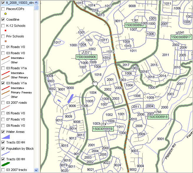
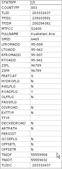
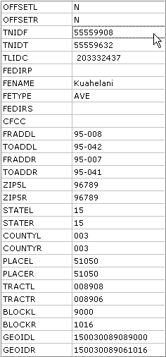
The identify tool is used to profile the streets segment by the pointer in above view. The attributes display is shown below in two sections. The first part, through TNIDT, is sourced from the edges shapefile dbf and maintaining original content and structure. The second part is sourced from fields in the edges shapefile dbf, faces dbf, and addr dbf. The second part contains fields that will be recognized by users of the previous streets shapefiles enabling use of this streets shapefile with legacy software.
First section of streets shapefile dbf record
|
Second section of streets shapefile dbf record
|
Page url: http://proximityone.com/hidmi/guide/index.html?roads_edge2street.htm