
|
|
|
how the U.S. population distribution has changed since 1940 .. welcome to this periodically updating section on how the U.S. population distribution has changed since 1940. Sign up to receive updates The decennial census has been conducted every 10 years since 1790. It provides the baseline data, the counts, of the population and housing for public use. These data are used widely to administer/evaluate programs and analyze population and housing characteristics and trends. The 1940 Census enumerated the United States and a11 territories (Alaska and Hawaii then territories) and possessions population to be 150,621,231; data released during World War II and tabulated without use of computers. The 2020 Census enumerated the U.S. population to be 331,449,281. This section chronicles how population and population density have changed by county since 1940. You can create similar map views, and more, through the use of the VDA Web GIS. Examining Population Distribution Change Starting with the 1940 Census We start with the 1940 Census due to several changes, maybe making it the start of the more modern census. Four notable changes were made starting with the 1940 Census, including the addition of the housing schedule, the sampling procedure, the addition of questions on employment and unemployment and questions on migration. With the advent of the 2010 Census, we lost the sample questionnaire/data and the questionnaire was reduced to the short form only. U.S. by county population density maps for the 48 contiguous state are presented below. These maps were developed using VDA GIS using the MetroDynamics database and GIS project. Patterns of Population Density based on the 1940 Census 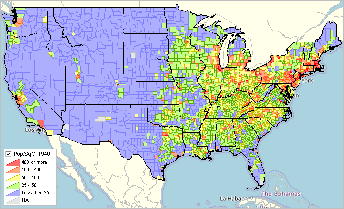
Patterns of Population Density based on the 2020 Census 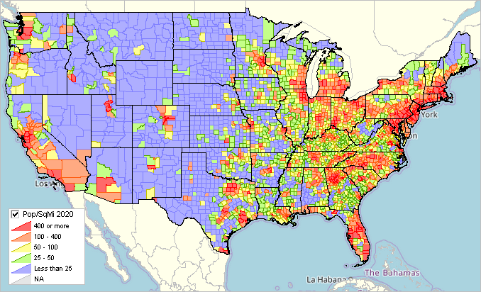
Examining County Level Detail The following graphic illustrates a zoom-in to a county/region with more detail. Centered on Harris County, TX (Houston), counties are labeled with the county name and 2020 Census population. 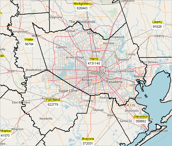
Using the select/profile tool, the fuller set of population data is shown for 1900 forward for Harris County.
Web Sessions Join us in the no cost every Tuesday, Wednesday, Thursday web sessions at 3:00 pm ET where we review topics such as this one. See more about topica and connectivity. Additional Information ProximityOne develops geographic-demographic-economic data and analytical tools and helps organizations knit together and use diverse data in a decision-making and analytical framework. We develop custom demographic/economic estimates and projections, develop geographic and geocoded address files, and assist with impact and geospatial analyses. Wide-ranging organizations use our tools (software, data, methodologies) to analyze their own data integrated with other data. Contact ProximityOne (888-364-7656) with questions about data covered in this section or to discuss custom estimates, projections or analyses for your areas of interest. |
|
|