
|
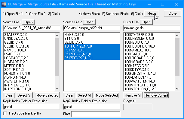
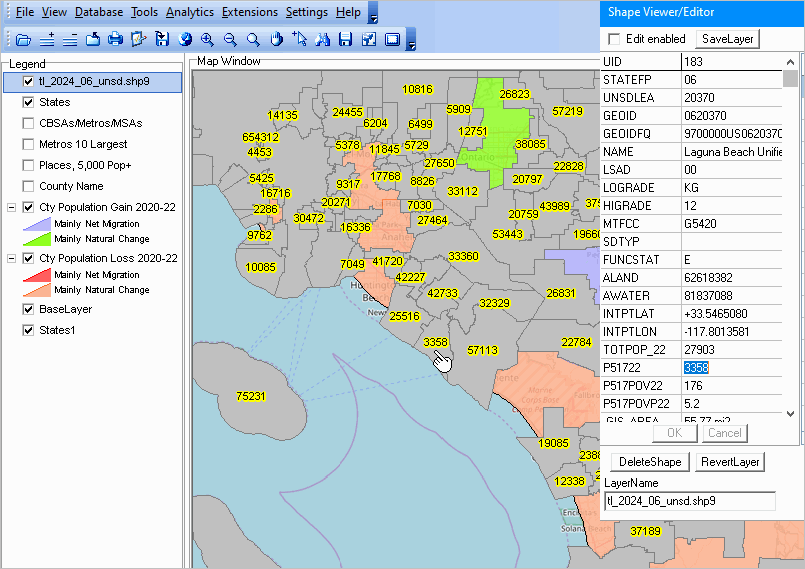
.. Module 4 Integrating Subject Matter with Shapefiles; Interpreting & Presenting Data Contents • Main -- Course Main Section • Module 1 -- About GIS; GIS Tools and Data Setup/Installation • Module 2 -- Geography, Geometry & Shapefiles • Module 3 -- Subject Matter: Statistical/Administrative Data • Module 4 (this module) -- Integrating Subject Matter with Shapefiles Interpreting & Presenting Data Module 4 -- iVDA-based Integrated Subject Matter & Geography; Interpreting & Presenting Data Learning Objectives • Ability to use CV XE GIS. • Understanding Scope & Content of VDAGIS Base Project. • Integrating K-12 Schools & School DIstrict Subject Matter with Geography (Shapefile). • Using the Integrated K-12 School & School District Subject Matter with Geography. • Adding the Shapefiles to a GIS Project. • Mapping & GeoSpatial Analysis using GIS Project. Topics .. Focus on K-12 Schools & School Districts • One approach -- use already integrated K-12 School & School District Data with ready-to-use iVDA. using iVDA K-12 School & School District Tools & Data • Review of Module 2 .. K-12 Schools & School Districts .. Geography. • Review of Module 3 .. K-12 Schools & School Districts .. Subject Matter. • Set the objective: map California unified school districts, enabling: - mapping school districts labeled with population age 5-17 in 2022. - creating a demographic profile for any unified school district. - we use the TIGER school district shapefiles (boundary geometry). - why use the "TIGER" shapefiles"? .. how to even know about these data? how to know these data are reliable. - are these data in a ready-to-use form for geospatial analysis? .. yes, but technical understanding is required - we use the SAIPE subject matter data. - why use the "SAIPE" data"? .. how to even know about these data? how to know these data are reliable. - are these data in a ready-to-use form for geospatial analysis? .. no - proceed as follows • Install CV XE GIS (optional; not installed in this session). • Acquire the School & School District Shapefiles. - review using only unified school districts .. only California Unified - saving as c:\cvxe\1\tl_2024_06_unsd.shp - by substituting the 2-digit state FIPS code, e.g. 20 (Kansas) for 06, optionally use any state. • Acquire the School & School District Subject Matter Data. - review using only school districts .. right-click SAIPE national scope dbf file and save to c:\cvxe\1 - saving as c:\cvxe\1\saipe_sd22.dbf - this is a national scope, all school disitricts file, and may be used with any state school district shapefile. - see more about these data • Merge Subject Matter data with shapefile data using the CV XE GIS Database>dBMerge Operation. - Source File 1: c:\cvxe\1\tl_2024_06_unsd.dbf - Source File 2: c:\cvxe\1\saipe_sd22.dbf - click Create button - set Key1 as field GEOID - set Key2 as field GEOID - in Source FIle 1 panel, click Select All then click Move Selected - in Source FIle 2 panel, select 4 demographic items then click Move Selected  - creating a new merged file c:\cvxe\1\tl_2024_06_unsd.shp - close dBMerge form; new shapefile shows in at top of legend panel • Using the new layer in the GIS project - c:\cvxe\1\tl_2024_06_unsd.shp is automatically added to the c:\cvxe\1\us1.gis project. - use the zoom tool to zoom to lower California; unified school districts show with a gray fill pattern. - use the CV XE GIS Layer Editor to Set Layer Properties -- why -- the design elements. - set the label on for field name "P51722" (population age 5-17 in 2022) - with mouse set as select tool, click on the Laguna Beach school district. The view now appears as shown below.  • Save the GIS project with the new name c;\cvxs\1\us1_casd.gis so that it can be reopened with the above view. • Examine Data; Draw Conclusions; Modify; Collaborate. • Documenting development. • Upcoming K-12 Public Schools 2022-23 (then 2023-24 in Feb 2025) Interactive Table. similar to existing K-12 Public Schools 2020-21 Interactive Table locale code. • Census Bureau Statistics in Schools • ProximtityOne/CC similar/differentiated program. End of Session. Optional details from earlier session follow. 4.1. Comparing iVDA with VDA Desktop GIS (VDAD) • Review of iVDA user interface and basic features using the VDAGIS Base project • Why this matters • iVDA Advantages & Limitations compared to VDA Desktop; feature comparison
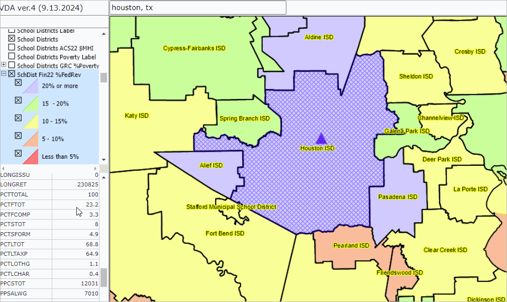
4.2. Role & scope of VDAGIS Base project; alternative projects .. goto top 4.2.1. VDAGIS Base project operates with all VDAGIS tools 4.2.2 Base Project Updates 09.25.24 Added School District Finances Layer Added 118th Congressional District ACS 2022-23 1yr Demographic Change Layer Added Revised 119th Congressional District Layer 4.2.3. Base Project Layer Groups World by CountryWorld by CountryStatesStatesStates Label State $PCPI %Chg 23Q1_24Q1 State $PCPI 24Q1 State Pop %Chg 2020-23 State Pop %Chg 2020-2023 State %Chg ForBorn2010-22 InterstateInterstateHospitalsHospitalsFDIC BanksFDIC BanksK-12 SchoolsK-12 Schools ElemK-12 Schools Middle K-12 Schools High County SubdivisionsCounty SubDivisionsTownships %PopChg 20-23 CBSAs - Core-Base Statistical Areas - MSAsCBSAs/MSA 2020 LabelCBSAs/MSA 2020 CBSA/MSA 2023 Name CBSA/MSA 2023 CBSA2023 Pop CBSA/MSA 2023 Pop23/SqMi Counties BoldCounties - BoldCongressional DistrictsCD118 CodeCD118 Boundary CD118 Bold CD118 ACS22 1yr Pop CD118 ACS22-23 1yr CD119 Code CD119 Boundary Congressional CommunitiesCong Comm CodeCong Comm CodeCong Communities Cong Comm ACS22 $MHI Label Cong Comm ACS22 $MHI Cong Comm DP1 Div Lbl Cong Comm %CVAP A22 Totpop Cong Comm %CVAP A22 Age18+ Cong Comm %CVAP A22 Totpop Cong Comm DP1 Diversity Cong Comm DP1 Dep Ratio CC ACS22 %HS Grad Congressional DistrictsCD 118 PopChg% 2020-22State Legislative DistrictsSt Leg Dist UpperSt Leg Dist Lower School DistrictsSchool Districts LabelSchool Districts School Districts ACS22 $MHI School Districts Poverty Label School Districts GRC %Poverty 2022 SchDist Fin22 %FedRev Urban AreasUrban Areas LabelUrban Areas ZIP Code AreasZIP Codes LabelZIP Codes ZIP Code HPI23>400 ZIP Code HPI22-23 %Chg Cities/PlacesCities/Places LabelCities/Places Cities 2023 Name Cities %PopChg 20-23 CountiesCounty NameCounty A22 $MHI Cty Pop Gain 2020-23 Cty Pop Loss 2020-23 Block GroupsBlkGroups CodeBlkGroups %CVAP A22 Totpop BlkGroups %CVAP A22 Age18+ BlkGroups %CVAP A22 Census TractsTracts CodeTracts Boundary Tracts Diversity Label Tracts DP1 Diversity Tracts DP1 Dep Ratio Tracts $MHI Tracts %LSAH Eng Not Well Tracts LMI23 Label Tracts LMI23 MFI Tract/MSA% Tracts %CVAP A22 Totpop Tracts %CVAP A22 Age18+ Tracts %CVAP A22 D001 Tracts Gini Index California Census BlocksCA Blocks CodeCA Blocks Boundary CA %HU Chg 20-24 x Block Counties LightCounties LightBase Layer - TopologyOSM Base LayerStates Base LayerStates Base Layer4.3. Using iVDA extended features .. goto top • Menu bar .. Tools>Layer Editor • Menu bar .. GeoSelect/Site Analysis • Table/Query • See iVDA below 4.4. iVDA applications .. goto top • Locating & examining a census tract - based on an address/location • Site Analysis using census tracts • K-12 Schools & School Districts • Congressional Communities & Congressional Districts • Examining Patterns of Low & Moderate Income 4.5. Assignment .. goto top Use iVDA in this section to create a view similar to the one shown below for school districts in an area of interest. Capture the graphic and e-mail (attachment) your profile (an Excel file) to Warren Glimpse.  4.6. Course Review & Ahead .. goto top Using iVDA .. goto top .. iVDA part of Visual Data Analytics .. see more about VDAGIS below .. iVDA works on any device; iPhone (not recommended due to screen size) .. start-up view presented below is an interactive mapping window .. watch video .. iVDA is an iframe version of VDA Web GIS4 ..open related VDA Web GIS4 .. sse about using VDA Web GIS4 below .. the page being viewed now is located at https://proximityone.com/gis/1/gis14.htm Metropolitan Statistical Area (MSA) GeoDemographics Click toggle button/line to view instructions. Examine any Metropolitan Statistical Area (zooms to MSA/CBSA)The vintage 2023 935 Core-Based Statistical Areas (CBSAs) in the U.S. (925) and Puerto Rico (10) are comprised of Metropolitan Statistical Areas (MSAs) and Micropolitan Statistical Areas (MISAs). CBSAs are comprised of one or more contiguous counties as defined by OMB. The 935 core-based statistical areas currently defined by the OMB include the 393 MSAs, which have an urban core population of at least 50,000, and the 542 (MISAs), which have an urban core population of at least 10,000 but less than 50,000. See more about CBSAs.Learn to examine MSAs using iVDA with the "Base" project; using the 2023 vintage metropolitan areas. See related interactive table. In the iVDA frame below, proceed as follows: In the Legend Panel at the left of the Map Window, scroll down to "CBSA/MSA 2023 Pop23/SqMi" layer and check on. .. click the + to left of name to expand the interval view The map view refreshes to show a thematic pattern view of the 2023 population by square mile by MSA. Click a MSA of interest in the map .. a demographic profile for that MSA is displayed in the lower left. .. here you can examine a wide range of demographic subject matter items. Examine metro drill-down characteristicsNext, examine a specific metrot; maybe the Dallas metro as an example.In the searchbar, key in "Dallas, TX" and press enter (no quotes, not case sensitive) .. the map refreshes showing a zoom-in to the Dallas, TX area Check on these layers: .. "Counties Bold" .. "County Name" .. "Tracts ACS22 $MHI" The map view now shows patterns of economic prosperity (median household income) by census tract for the Dallas, TX MSA. .. using data from the American Community Survey 2022 (ACS202) View a demographic-economic profile for any selected tract: .. click on a tract the map (see pointer in example below); the lower left panel profile updates. .. a demographic profile for that tract is displayed in the lower left. .. here you can examine a wide range of demographic subject matter items. The start-up shows the U.S. lower 48 states by county. .. reviewing extended features: Menu bar>Tools>Layer Editor .. Menu bar>GeoSelect/Site Analysis .. Table/Query About VDAGIS .. goto top Visual Data Analytics (VDA) Geographic Information Resources (GIS) resources are developed and maintained by Warren Glimpse, ProximityOne (Alexandria, VA) and Takashi Hamilton, Tsukasa Consulting (Osaka, Japan). See more about VDA resources |
|
|