|
|
|
.. 50 years of change April 2026 .. A University of Missouri initiative, Warren Glimpse, founder of ProximityOne, and a colleague started development of what would become the Columbia (Boone County). MO Geographic Base File/Dual Independent Map Encoding File (GBF/DIME) in 1972. Later it would become the prototype for the Census Bureau Topologically Integrated Geographic Encoding and Referencing (TIGER) System. See more about the Columbia, MO MSA in context of all Core-Based Statistical Areas (Metropolitan and Micropolitan Statistical Areas) Who is this for? Stakeholders interested in: • the evolution of the TIGER system • data journalists bridging the gap investigative reporting and data science • what today's technology brings through the use of VDAGIS and TIGER data • a specific sphere of analysis; e.g., school districts and schools • participants in the Census Bureau State Data Center Program • librarians and information management specialists Change Over 50+ Years • Columbia, MO city is wholly contained in Boone County (1970, 2025). • Columbia, MO city grew in population from 58,521 (1970) to 130,900 (2024). • the land area of Columbia city increased from 23.9 SqMi (1970) to 67.17 SqMi (2025). • Boone County has grown in population from 80,911 (1970) to 191,746 (2025). • Boone County was a single county MSA (1970) and part of a three county (Boone, Cooper, Howard) MSA (2025). 1970-2025 Data & Maps • Census of Population and Housing: 1970; Census Tracts: Columbia, Mo. SMSA -- 1970 Census Map • Current Columbia, MO MSA Profile • See current interactive map below. Current Columbia, MO MSA in Context of Missouri Columbia, MO MSA shown as cross-hatched 3-county area in center of state. 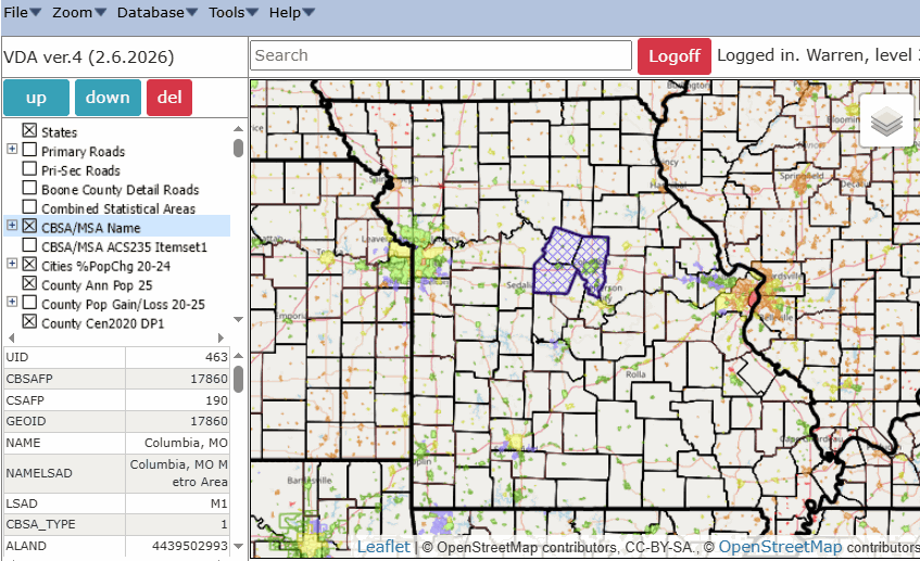 .. static map prepared using columbia_mo.gis project and VDAGIS tools Development of Columbia, MO GBF/DIME Census Bureau staff from Suitland, MD came to the University in Columbia to provide training on the process. Parts of a wall map sent to us by the Census Bureau. We built an even larger wall map maybe 7’x7’ or larger. Street intersections were designated by orange dots that were placed/rubbed onto a mylar map. Each dot was maybe 1/8 inch, in reality each dot was roughly 40 feet in diameter. Dots were applied to all of Columbia city and Boone County. Those maps were sent back to Census and the orange dots were digitized and became latitude-longitude. At the time the University of Missouri bureau of business and economic research was also a part of the DUALabs START community and the largest Summary Tape Processing Center (STPC). Using iVDA with the Columbia, MO MSA .. goto top .. login within 10 minutes .. no cost. .. this project uses almost all current TIGER-based shapefiles and related resources .. the initial view shows the 2025 depiction of Columbia city (green) .. an application: check the square box to show layer "Boone County Detail Roads" key in "1808 Ridgemont, Columbia, MO" to the search bar and press Enter a triangle/marker is shown at the location or key in "Jesse Hall, Columbia, MO" to the search bar and press Enter a triangle/marker is shown at the location (zoom in, uncheck "Cities " layer name) .. iVDA part of Visual Data Analytics .. about VDAGIS below .. iVDA works on any device; iPhone (not recommended due to screen size) .. iVDA is an iframe version of VDA Web GIS4 ..open related VDA Web GIS4 Visual Data Analytics Web GIS iVDA is presented below in an interactive mapping window ... Adding Your Locations .. goto top Add your own shapes or other locations to the project. While TIGER provides an excellent source of shapefile data, users of the TIGER API GeoCoder will find its use for geocoding addresses has only about 70-percent hit rate. We recommend using the embedded VDAGIS geocoder available via Tool>Geocoding which provides near 100-percent rooftop geocoding -- depends on quality of address used. Try it yourself using these 5 high school addresses in the Columbia Public Schools school district: Battle High School, 7575 East St. Charles Road, Columbia, MO, 65202 Douglass High School, 310 N. Providence Rd, Columbia, MO, 65203 Hickman High School, 1104 N Providence Rd, Columbia, MO, 65203 Rock Bridge High School, 4303 S Providence Rd, Columbia, 65203 Columbia Area Career Center, 4203 S Providence Rd, Columbia, MO 65203Steps: • Start the Tools>Geocoding from the menu bar. • Copy and paste the above 5 addresses (or any set of addresses) into the Geocoding form • Click the Run on the form. The 5 addresses are shown as new marker shapefile and markers in the map. Note also using the profile feature (see pointer in map) data are displayed about the location including address, latitude, longitude, and form of geocoding (rooftop). 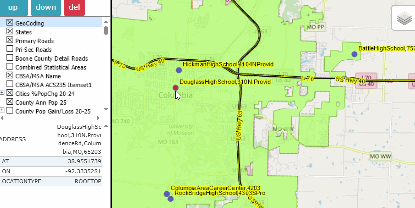
This zoom-out view shows the school district cross-hatched and the 5 high schools with labels removed. 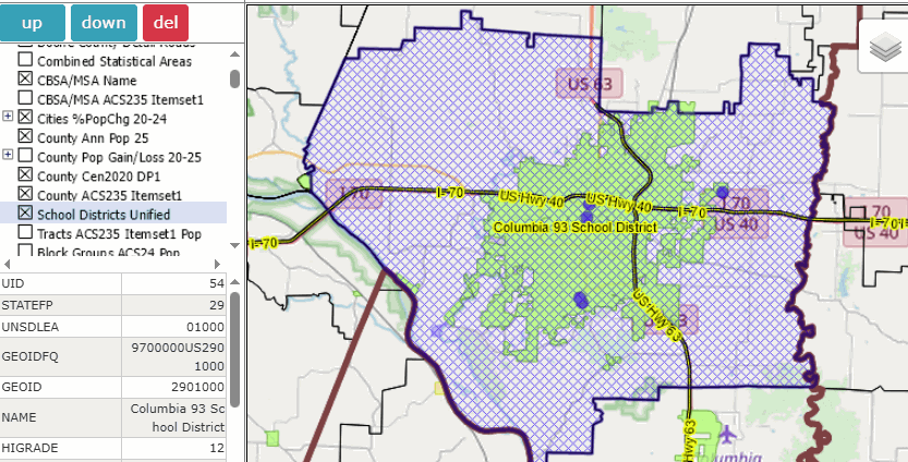
Add/Change Geography/Subject Matter .. goto top Add your own geography or subject matter to the project. • Adding/Changing Geography (File>Uploading shapefiles) • Adding/Changing Subject Matter (changing item displayed -- Tools>Layer Editor) • Using the separate Demographic Economic Data Explorer (DEDE) • Saving the Project (File>Save Project) • Recalling the Project (File>Open Project) About VDAGIS .. goto top The Visual Data Analytics (VDA) Geographic Information System (GIS) is a suite of tools and data that you can use to examine multi-sourced geographic, demographic and economic data. VDAGIS resources are developed and maintained by Warren Glimpse, ProximityOne (Alexandria, VA) and Takashi Hamilton, Tsukasa Consulting (Osaka, Japan). See more about VDAGIS. Add your own data. Support Using these Resources .. goto top Learn more about accessing and using demographic-economic data and related analytical tools. Join us in a Data Analytics Lab session. There is no fee for these one-hour Web sessions. Each informal session is focused on a specific topic. The open structure also provides for Q&A and discussion of application issues of interest to participants. ProximityOne User Group Join the ProximityOne User Group to keep up-to-date with new developments relating to geographic-demographic-economic decision-making information resources. Receive updates and access to tools and resources available only to members. Use this form to join the User Group. Additional Information ProximityOne develops geographic-demographic-economic data and analytical tools and helps organizations knit together and use diverse data in a decision-making and analytical framework. We develop custom demographic/economic estimates and projections, develop geographic and geocoded address files, and assist with impact and geospatial analyses. Wide-ranging organizations use our tools (software, data, methodologies) to analyze their own data integrated with other data. Contact ProximityOne (888-364-7656) with questions about data covered in this section or to discuss custom estimates, projections or analyses for your areas of interest. |
|
|