
|
|
|
In 2020, centenarians (people of age 100 or more) accounted for just 2 out of 10,000 people. Centenarians in the U.S. increased by 50% from 53,364 in 2010 to 80,139 in 2020. This section provides more information and 2020 centenarians and how this group has changed since 2010. The number of centenarians are tabulated as summary statistics for census tracts and higher geographic levels from Census 2020. The number and characteristics of centenarians may also be tabulated from the annual American Community Survey 5-year and 1-yesr Public Use Microdata Sample (PUMS) files for Public Use Sample Areas (PUMA). Here, we focus on number of centernarians by state from Census 2020. Patterns of Centenarians, 2020, in the Lower 48 States .. click graphic for larger view .. see inset legend for values .. labels show the actual number of centenarians from Census 2020. 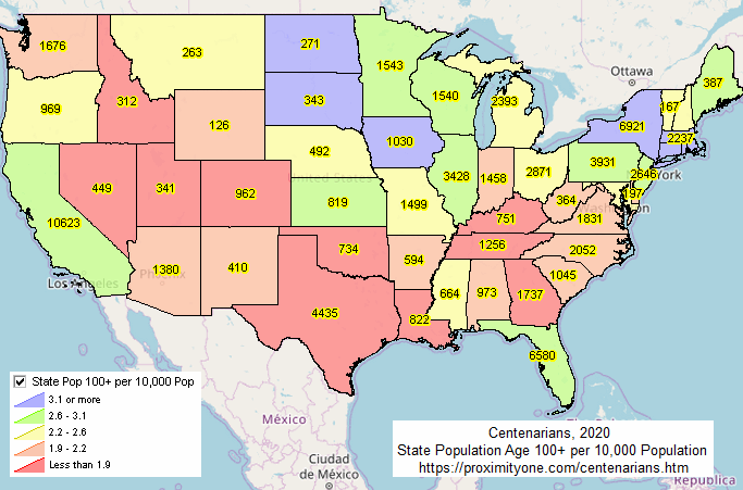 Use the Visual Data Analytics VDA - American Community Survey Data Profiles (VDA_DP) GIS project using iVDA or VDAW4 to examine centenarians. The start-up view of the VDA_DP GIS project using iVDA is shown below. Using iVDA with the VDA ACS DP Project to Examine Centenarins .. goto top .. the starting view shows the lower 48 states with patterns of centenarians by stste. .. this dynamic view is similar to the static maps view shown above. Make Your Own Views of Centenarians The above static map was generated using the VDA GIS tool and the VDA GIS project. Use this base map, online, to make variations. Use other data as labels. Create zoom views. Create different intervals and/or subject matter. More Detail See the Census Bureau report on centenarians. Join In Join us in the weekly web sessions training and support sessions. Learn about using the housing related data and a wider array of demographic-economic data for many types of geography. Support Using these Resources [goto top] Learn more about demographic economic data and related analytical tools. Join us in a Data Analytics Lab session. There is no fee for these Web sessions. Each informal session is focused on a specific topic. The open structure also provides for Q&A and discussion of application issues of interest to participants. ProximityOne User Group [goto top] Join the ProximityOne User Group to keep up-to-date with new developments relating to geographic-demographic-economic decision-making information resources. Receive updates and access to tools and resources available only to members. Use this form to join the User Group. Additional Information ProximityOne develops geodemographic-economic data and analytical tools and helps organizations knit together and use diverse data in a decision-making and analytical framework. We develop custom demographic/economic estimates and projections, develop geographic and geocoded address files, and assist with impact and geospatial analyses. Wide-ranging organizations use our tools (software, data, methodologies) to analyze their own data integrated with other data. Contact us (888-364-7656) with questions about data covered in this section or to discuss custom estimates, projections or analyses for your areas of interest. |
|
|