
|
|
|
|
-- create custom estimates for 2,378 U.S. wall-to-wall areas (PUMAs) -- expanding insights through data analytics March 2022 .. the 2020 American Community Survey (ACS) 5-year PUMS release date is March 31, 2022. See more about the ACS 2020 5-year PUMS here. Public Use Microdata Sample (PUMS) files provide a way to develop custom estimates of demographic summary statistics for Public Use Microdata Areas (PUMAs), states and the U.S. This section is focused on selected PUMS files enabling custom estimates for 2010 PUMAs: • Census 2010 PUMS (released November 2014) • American Community Survey (ACS) 5-year PUMS .. ACS 2018 (Jan 2019) .. ACS 2019 (Jan 2020) .. ACS 2020 (Mar 2022) These PUMS files are comprised of samples of individual respondent person and housing unit records. The ACS PUMS files are released annually providing a means to develop similar custom estimates with annual updates. For example, public and private school enrollment by grade for specific universes (e.g. by other attributes of person such as language spoken, poverty status etc.) not available elsewhere. These summary statistic estimates can be developed using the PUMS data using crosstab software. Thousands of subject matter combinations are possible. About PUMS Public Use Microdata Sample (PUMS) files contain a sample of respondent level data from a decennial census or American Community Survey (ACS). Each record in the person file represents a single person; each record in the housing unit file represents a single housing unit. In the person-level file, individuals are organized into households, making possible the study of people within the contexts of their families and other household members. Each person or housing unit record contains fields/variables for nearly every question in the census/survey, as well as many new items derived responses (such as poverty status). Each annual ACS PUMS file contains data on approximately one percent of the U.S. population. Since all responses are confidential, many variables in the PUMS file have been modified to protect the confidentiality of survey respondents. For instance, particularly high incomes are "top-coded", uncommon birthplace or ancestry responses are grouped into broader categories, and the PUMS file provides a very limited set of geographic variables. PUMS Datasets • Census 2000 PUMS ... uses Census 2000 PUMAs ... earlier PUMS available • ACS2008 .. ACS2011 PUMS uses Census 2000 PUMAs • ACS2012 PUMS ... uses Census 2010 PUMAs released fall 2013 • ACS20y1 PUMS ... uses Census 2010 PUMAs released fall 20y2; future years y1=13 forward; y2=y1+1 • Census 2010 PUMS • Other PUMS available; covered in other sections Data for Public Use Microdata Areas While PUMS files contain data for respondents across the U.S., most lower level geography are not identified by any variables in the PUMS files. The most detailed unit of geography contained in the PUMS files is the Public Use Microdata Area (PUMA). See details about PUMAs and interactive table. PUMAs are special non-overlapping areas that partition each state into contiguous geographic units containing no fewer than 100,000 people each. 2010 PUMAs were built on census tracts, and cover the entirety of the United States, Puerto Rico, Guam, and the U.S. Virgin Islands. Mapping PUMAs -- reference and thematic pattern applications The following graphic illustrates how you can use VDA Web GIS to view Public Use Microdata Areas (PUMAs) contextually relative to topography or other geostatistical data. In this example the Find Address feature is used to zoom to downtown Los Angeles and show PUMA boundaries and codes. An arbitrary PUMA is clicked to show the demographic profile for that PUMA (crosshatched). This view illustrates using the VDA Table where each row corresponds to a PUMA. In this example, total population and median household income are displayed as selected columns; the table is sorted in descending order on median household income. 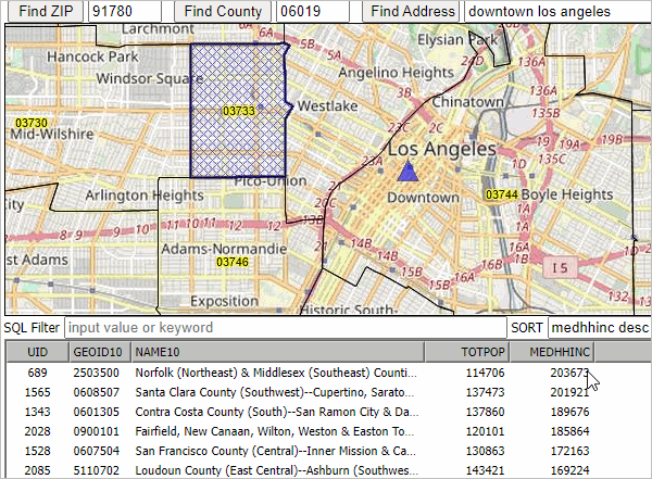
Support Using these Resources Learn more about accessing and using demographic-economic data and related analytical tools. Join us in a web session. There is no fee for these one-hour Web sessions. Each informal session is focused on a specific topic. The open structure also provides for Q&A and discussion of application issues of interest to participants. ProximityOne User Group Join the ProximityOne User Group to keep up-to-date with new developments relating to metros and component geography decision-making information resources. Receive updates and access to tools and resources available only to members. Use this form to join the User Group. Additional Information ProximityOne develops geodemographic-economic data and analytical tools and helps organizations knit together and use diverse data in a decision-making and analytical framework. We develop custom demographic/economic estimates and projections, develop geographic and geocoded address files, and assist with impact and geospatial analyses. Wide-ranging organizations use our tools (software, data, methodologies) to analyze their own data integrated with other data. Contact us (888-364-7656) with questions about data covered in this section or to discuss custom estimates, projections or analyses for your areas of interest. |
|
|