
|
|
|
|
.. more than 102,000 individual schools; 49 million students January 2026 .. K-12 public schools are at the heart of the school district community. This section provides access to data for each of the 102,268 K-12 public schools (95,879 reported as schools with students). Use the interactive table below to query, view compare schools. Learn about examining schools in context of other geography and subject matter. Topics in this section: • K-12 Public Schools Interactive Mapping • K-12 Public Schools Interactive Table • K-12 Public SchoolsCongressional Communities • Visual Data Analytics • Related Sections; New & Upcoming Data Developments K-12 Public Schools Interactive Table; 2024-25 .. goto top Use the buttons & tools below the table for most effective use of this table and data. Click ShowAll button between Find/Queries. Use mouseover on column header to view column description. See usage notes below table. Usage Notes .. Click header cell to sort; click again to sort in other direction. .. Use buttons below table to query or place filters on the table. .. -1 indicates data not available or not applicable .. use buttons below the table to filter schools/rows shown in the table. .. generally, click ShowAll button between queries. .. several buttons have default values for the Orange County, CA area. - Find LEAID .. filter on an Local Education Agency ID - Find in Name .. filter on Name (Col 1) for exact spelling in a string - Find in City .. filter on City (Col 9) for exact spelling in a string - Find County .. filter on StCty (col 12) using 5-character State+County FIPS Code - Find ZIP .. filter on ZIP Code (col 10) using 5-digit ZIP code .. Starting SY 2022-23, Title I status data were released by OESE November 2024; these data will be added to the above table. Column header/notes:
- Name
- St - GeoID - LEAID - St1 - StSch - StLEA - Street - City - St3 - ZIP - StCtY - Locale - CBSA - CBSA Type - Phone - School Type - LEA Type - Charter - Shared Time - Virtual - Natl Schl - Supervisor - Sch Level - Lo Grade - Hi Grade - Students - Free Lunch - Direct Cert - RedFee Lunch - Free & Red Fee lunch - Grade 1-8 - Grade 9-12 - Grade PK - Grade KG - Grade 1 - Grade 2 - Grade 3 - Grade 4 - Grade 5 - Grade 6 - Grade 7 - Grade 8 - Grade 9 - Grade 10 - Grade 11 - Grade 12 - Grade 13 - UNGRADED - ADULT_EDUC - MALE - FEMALE - Amer Indian - Asian - Hispanic - Black - Native Hawaii OPI - White - Multi Race - Total Race - Web Site School Locale Codes where UA: Urbanized Area; UC: Urban Cluster; PC: Principal City 11 ... City, Large: area inside UA & inside PC & population >= 250,000. 12 ... City, Midsize: area inside UA & inside PC & population 100,000-250,000. 13 ... City, Small: area inside UA & inside PC & population < 100,000. 21 ... Suburb, Large: area outside PC & inside UA & population >= 250,000. 22 ... Suburb, Midsize: area outside PC & inside UA & population 100,000-250,000. 23 ... Suburb, Small: area outside PC & inside UA & population < 100,000. 31 ... Town, Fringe: area inside UC that is <= 10 miles from UA. 32 ... Town, Distant: area inside UC that is 10-35 miles from UA. 33 ... Town, Remote: area inside UC that is > 35 miles from UA. 41 ... Rural, Fringe: non-urban area <= 5 miles from UA & <= 2.5 miles from UC 42 ... Rural, Distant: non-urban area 5-25 miles from UA & 2.5-10 miles from UC 43 ... Rural, Remote: non-urban area >= 25 miles from UA & >= 10 miles from UC Free and Reduced Fee Price Lunch Table Query Example & FRPL Eligibility .. goto top Use the interactive table above to learn that there are 22 schools in Cowley County, Kansas (use iVDA interactive mapping to view as a map). Replicate creation of graphic shown below using these steps (use this sequence of steps): • click ShowAll button. • click Free Lunch button .. select a different ColSet button for different subject matter. • enter state+FIPS code (20035) in the Find County edit box; click Find County Lunch button. • try your own county The following view is a static graphic; use interactive table to create this or similar view for another area. This tool enables stakeholders to understand the impact of student participation/funding from the Federal FRPL program. 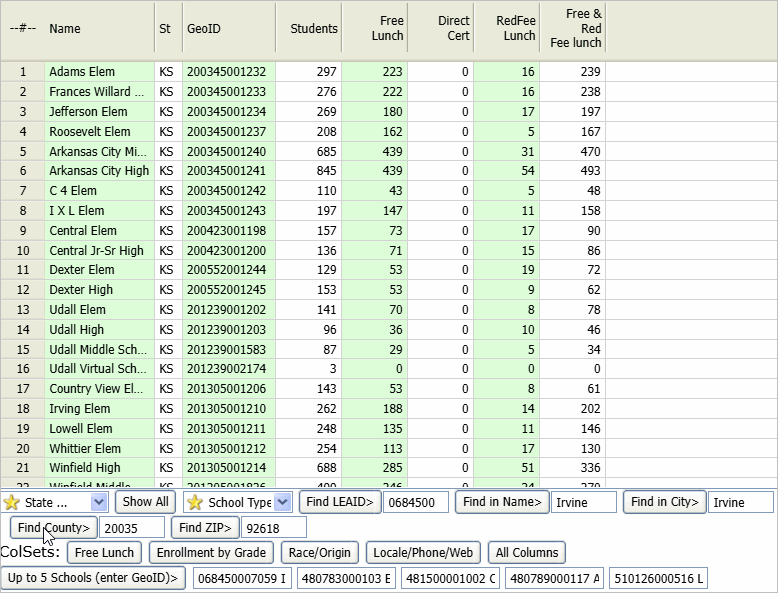 About FRPL Eligibility The number of students eligible for the National School Lunch Program (NSLP), a U.S. Department of Agriculture (USDA) meal program that provides nutritionally balanced low-cost or free meals to children during the school day. The program was established under the National School Lunch Act, signed into law by President Harry Truman in 1946, and currently serves nearly 30 million children. Free or Reduced-Price Lunch vs Direct Certification Historically, student eligibility for free or reduced-price lunch (FRPL) was determined through individual students submitting school meals application forms within school districts. In 1986, the USDA introduced a direct certification option to reduce participation barriers in the school meal program. Under direct certification, any child belonging to a household that participates in Supplemental Nutrition Assistance Program (SNAP), Temporary Assistance for Needy Families (TANF), Food Distribution Program on Indian Reservations (FDPIR), or (in some states) Medicaid - as well as children who are migrant, homeless, in foster care, or in Head Start - are categorically eligible to receive free meals at school. The NSLP data shown in this section include school-level FRPL and direct certification eligibility counts for all public schools with students enrolled. These point-in-time counts are taken on or around October 1 of each school year and reported by the states based on the following guidance: FRPL-Eligible Students • Free lunch students: those eligible to participate in the Free Lunch Program (i.e., those with family incomes below 130 percent of the poverty level or who are directly certified) • Reduced-price lunch students: those eligible to participate in the Reduced-Price Lunch Program (i.e., those with family incomes between 130 and 185 percent of the poverty level) • Free and reduced-price lunch student: the total of free lunch students and reduced-price lunch students • Direct Certification: The number of students reported as categorically eligible to receive free meals to the USDA for the FNS 742. Students are categorically eligible to receive free meals if they belong to a household receiving the selected federal benefits noted above or are migrant, homeless, in foster care, or in Head Start. The count of students eligible for free lunch includes students directly certified plus any students who qualified for free lunch by completing a school meals application. As such, the number of students reported as directly certified should always be less than or equal to the number of free lunch students. Note that changes in SNAP (both legislated eligibility requirements and temporary changes such as national disasters) can have implications for reported NSLP eligibility as well. Congressional Communities .. goto top See about Congressional Communities Examine Congressional Communities using the above iVDA interactive mapping shown above. For example, after creating the view for CA CD47, click the checkbox on for the "Comm Cong Code" layer. .. the following view is now shown in the map window: 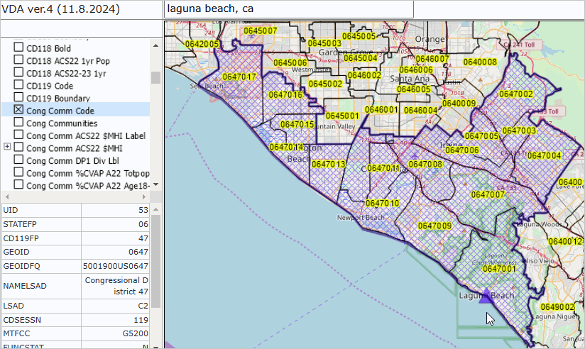 About VDAGIS .. goto top The Visual Data Analytics (VDA) Geographic Information System (GIS) is a suite of tools and data that you can use to examine multi-sourced geographic, demographic and economic data. VDAGIS resources are developed and maintained by Warren Glimpse, ProximityOne (Alexandria, VA) and Takashi Hamilton, Tsukasa Consulting (Osaka, Japan). See more about VDAGIS. Add your own data. Related Sections; New & Upcoming Data Developments .. goto top Census CD119 section Frequently Asked Questions .. goto top Supplemental Nutrition Assistance Program (SNAP) - Provides food benefits to lower-income individuals and families. - SNAP benefits can be used like cash to buy eligible food items from authorized retailers. Free and Reduced Priced Lunch (FRPL) - A school meal program that provides free or reduced-price meals to students. Students may qualify for FRPL if they: - Are part of a household that receives SNAP, TANF, or FDPIR benefits - Are identified as a foster child - Are homeless, runaway, or migrant - Meet the Federal Income Eligibility Guidelines - Support Using these Resources .. goto top Learn more about accessing and using demographic-economic data and related analytical tools. Join us in a Data Analytics Lab session. There is no fee for these one-hour Web sessions. Each informal session is focused on a specific topic. The open structure also provides for Q&A and discussion of application issues of interest to participants. ProximityOne User Group Join the ProximityOne User Group to keep up-to-date with new developments relating to geographic-demographic-economic decision-making information resources. Receive updates and access to tools and resources available only to members. Use this form to join the User Group. Additional Information ProximityOne develops geographic-demographic-economic data and analytical tools and helps organizations knit together and use diverse data in a decision-making and analytical framework. We develop custom demographic/economic estimates and projections, develop geographic and geocoded address files, and assist with impact and geospatial analyses. Wide-ranging organizations use our tools (software, data, methodologies) to analyze their own data integrated with other data. Contact ProximityOne (888-364-7656) with questions about data covered in this section or to discuss custom estimates, projections or analyses for your areas of interest. |
|
|