
|
|
|
American Community Survey Data Profiles .. 119th CD/CC ACS Data Profiles: Demographic, Social, Economic, Housing .. use with Visual Data Analytics (VDA) Geographic Information Systems (GIS) The U.S. 435 119th Congressional Districts (Jan 3, 2025 to Jan 3, 2027) have an average population of approximately 763,000 population, larger than three states. Some CDs have grown so much they now exceed 1 million population. The size and diversity of CDs can make it difficult to communicate effectively with Congress. Congressional Communities are subdivisions of Congressional Districts, and can help Americans better have their voice heard by Congress. Benefits from Using 119th CD/CC VDA • only source of integrated 119th CD and CC data in a GIS context .. unique ability to use demographic-economic data by CD and/or CC • current American Community Survey data availability • standard "Group One" GIS project layers 119th Congressional Community and Congressional Districts -- Southern California .. a static graphic .. use iVDA below to create this view .. examine the median household income differences in CD CA 37 in this view. 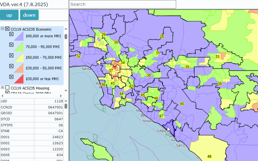 119th Congressional Community and Congressional Districts It is important to distinguish between 119th Congressional Community and Congressional Districts. These geographies relate to one another is several ways. 119th Congressional Districts • the United States 119th Congress is in session from Jan 3, 2025 to Jan 3, 2027. • examine the 435 119th Congressional Districts reflecting the November 2024 elections . • shapefiles integrated with American Community Sutvey 2023 1-year data profiles. . Congressional Communities • 7,406 polygons subdividing each 119th Congressional District. • proprietary geography and demographics developed by Congressional Communities. • shapefiles integrated with American Community Sutvey 2023 5-year data profiles. Using the 119th CD/CC VDA GIS Project Use the 19th CD/CC VDA GIS Project with: • iVDA -- embedded version of VDAW4, web-based, nothing to install • VDAW4 -- web-based, nothing to install • VDA Desktop -- most powerful, Windows based. To find a 119th CD or CC: 1. Enter an address in the iVDA interactive mapping search bar and press Enter. 2. The map view will relocate to the corresponding CD or CC. Use the 119th CD/CC American Community Survey Data Profiles (119CD/CC DP) GIS project using iVDA or VDAW4. The start-up view of the 119CD/CC DP GIS project using iVDA is shown below. Using iVDA with 119th CD/CC ACS DP Project .. goto top .. The starting view shows the lower 48 states by county. .. the page being viewed is located at https://proximityone.com/119cdcc.htm. Metadata Metadata files describe the fields in corresponding layers, with illustrative sample views (click graphic for larger view). .. each graphic shows view of item from that layer. ACS Demographic XLS -- 94 statistical items percent Hispanic by 119th Congressional District 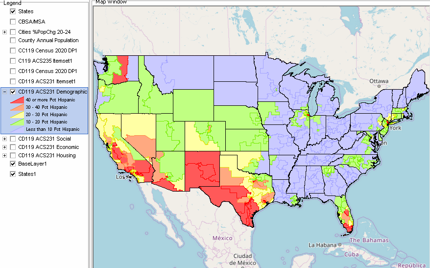 ACS Social XLS -- 154 statistical items percent College Graduates by 119th Congressional District 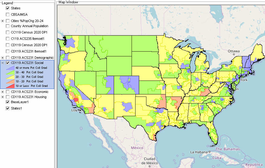 ACS Economic XLS -- 137 statistical items Median Household Income by 119th Congressional District 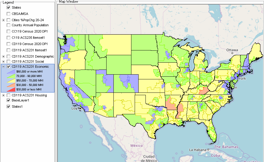 ACS Housing XLS -- 143 statistical items Median Housing Value by 119th Congressional District 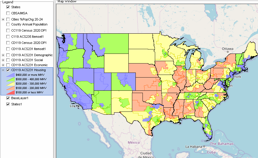 The 119th CD/CC VDAGIS Project -- a "Group One" GIS Project .. goto top There are several Group One VDA GIS projects further described in the VDA4 GIS project Main Menu section. Group One Projects have these properties: .. focused on one geography. .. comprised of approximately 10 layers. .. contain the identical, most recent data for these layers: States CBSA/MSA Counties Cities States1 Base layer -- topology Structure of the 119 CD/CC GIS Project Core CD and CC laters: .. CC119 Census 2020 DP1 .. CD119 ACS231 Itemset1 .. CC119 ACS235 Itemset1 .. CC119 ACS235 Demographic .. CC119 ACS235 Social .. CC119 ACS235 Economic .. CC119 ACS235 Housing .. CD119 Census 2020 DP1 .. CD119 ACS231 Demographic .. CD119 ACS231 Social .. CD119 ACS231 Economic .. CD119 ACS231 Housing Role of GIS and Analysis of Census Tracts A Geographic Information System (GIS) is a computer -based tool that allows users to store, analyze, visualize, and interpret geographic data. Geographic data, also known as spatial or geospatial data, identifies the location of features on earth. GIS combines the visual elements of maps with the ability to link characteristics about those features in datasets. This relationship allows GIS to locate, display, analyze, and model data. GIS technology integrates geographic data with statistical and administrative data using statistical methods and analytics. These abilities make GIS valuable to a wide range of public and private enterprises for explaining events, predicting outcomes and planning strategies. And collaborating on those issues. About iVDA & VDAGIS .. goto top iVDA is an HTML iframe embedded version of VDA Web GIS. VDAGIS tools and data have been developed and are updated/supported by Warren Glimpse/ProximityOne/Alexandria, VA USA and Takashi Hamilton/Tsukasa/Osaka, Japan. Support Using these Resources .. goto top Learn more about census tract demographic economic data and related analytical tools. Join us in a Data Analytics Lab session. There is no fee for these informal sessions focused on your interests. The open structure provides for Q&A and discussion of application issues of interest to participants. Terms of Use .. goto top There is no warranty regarding any aspect of this using this project. The user is solely responsible for any use made of iVDA or data contained in project files. Contact ProximityOne (888-364-7656) with questions about data covered in this section or to discuss custom estimates, projections or analyses for your areas of interest. |
|
|