
|
|
|
State Legislative Districts The tools used here apply to any state's 119th Congressional Districts and 2024 State Legislative Districts. Kansas is used to illustrate the process. Kansas contains four 119th Congressional Districts (CDs) and 125 Lower State Legislative Districts (House - SLDLs). This section provides access to tools to examine these CDs and SLDLs to conduct political analysis. In the 2024 general election, Republicans strengthened their supermajority in the Kansas House of Representatives, gaining three seats to reach a total of 88 seats (up from 85), while Democrats fell to 37 seats (down from 40). Because the threshold for a supermajority in the 125-seat chamber is 84, this result ensures Republicans maintain a veto-proof majority, allowing them to override the Kansas Governor's vetoes. Table of contents 1. Statewide House 2024 Election Results 2. Kansas House Election Results 2024 3. Using VDA to Examine Kansas Congressional Districts and State Legislative Districts 4. Join us in a Web Session 5. ACS 2024 Citizen Voting Age Population by Race 6. ACS 2024 Data Profiles 7. Vintage 2025 Population Estimates and Components of Change 8. TIGER 2025 -- Topologically Integrated Geographic Encoding and Referencing 9. Congressional Communities 10. Data Sources 11. Intended Users 1. Kansas House Election Results 2024 -- Statewide View .. Red R; Blue D .. static map generated from interactive iVDA below (details). .. click graphic for larger view. 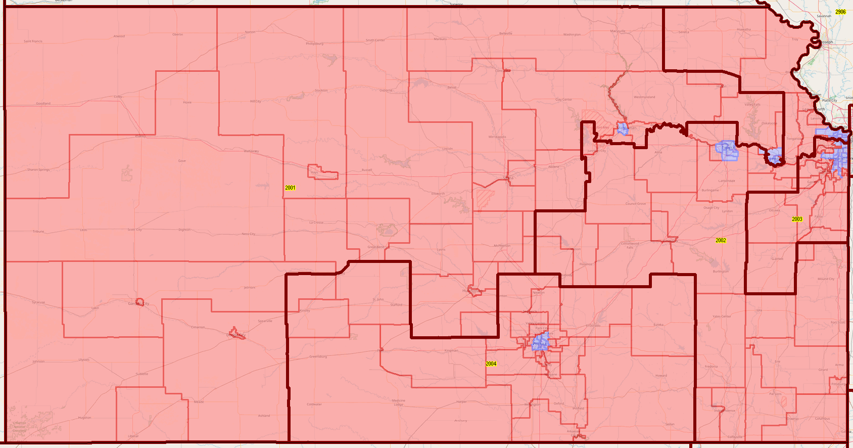 2. Kansas House Election Results 2024 Use the buttons & tools below the table for most effective use of this table and data. Click ShowAll button between Find/Queries. Use mouseover on column header to view column description. See usage notes below table. Usage Notes .. click header cell to sort; click again to sort in other direction. .. use buttons below table to query or place filters on the table. .. enter a city name and click Find City to view SLDs in that area. .. county button is not active. Items in Table .. District .. Kansas House Code .. Incumbent .. elected in November 2024 .. Incumbent Party .. Incumbent Votes .. votes for incumbent .. Incumbent Percent of total votes .. GeoID .. Federal code for house district .. City .. primary city of district .. Total Vote .. total votes in this district .. Uncontested .. U indicates there was no opponent .. CVAP235 .. Citizen Voting Age Population; American Community Survey 2023 5 year data .. Total Votes / CVAP235 .. ratio of Toral Votes (adminstrative data) to CVAP235 .. $MHI 235 .. Median Household Income ACS 2023 3. Using VDA to Examine Kansas Congressional Districts and State Legislative Districts .. goto top .. the starting view is focused on Wichita; SLDs are shown with bold boundary and code; colored by 2024 elected party .... voting precincts are shown with lighter black boundary. .. use VDAW4 for full-screen view. See below for more detail. .. note that without a login, the application will prompt for a login after 10 minutes. .... with a login, you will be a Level 1 user with unlimited time. No fee. .... next time use your login ID (e-mail) and password. Example To replicate the first static view, proceed as shown here from start screen. In Legend Panel .. .. login .. create account. .. uncheck layer Cities Name .. uncheck layer SLDL 24 .. check layer SLDL 24 Party .. uncheck layer Block Groups ACS 23 CVAP .. click "zoom out magnifying glass" below map 4 times; adjust as required. More Detailed Featured of the GIS Project .. goto top - provided to subscribers. Use VDA GIS for Further Analysis .. goto top The Visual Data Analytics (VDA) Geographic Information System (GIS) was used to develop the above maps. You can use VDA GIS to develop variations of the maps; different intervals, colors, zooms, etc. There is nothing to install. VDAGIS tools and data have been developed and are updated/supported by Warren Glimpse/ProximityOne/Alexandria, VA USA and Takashi Hamilton/Tsukasa/Osaka, Japan. 4. Join us in a Web Session .. goto top Learn more about accessing and using demographic-economic data and related analytical tools. Join us in a Web session. No fee. Learn about the American Community Survey (ACS 2024} and Vintage 2025 population estimates and components of change. The open structure also provides for Q&A and discussion of application issues of interest to participants. 5. ACS 2024 Citizen Voting Age Population by Race .. goto top Join us in a Web session to learn about using resources on this page. Also learn how you can benefit from other data resources such as the ACS 2024 Citizen Voting Age Population by Race. Developed as a special tabulation sponsored by the U.S. Department of Justice, these data provide Citizen Voting Age Population by Race down to the block group geographic level. We cover these data in the web session and provide information on how to access and use these data. Example -- CVAP 24 Hispanic -- two Kansas House districts 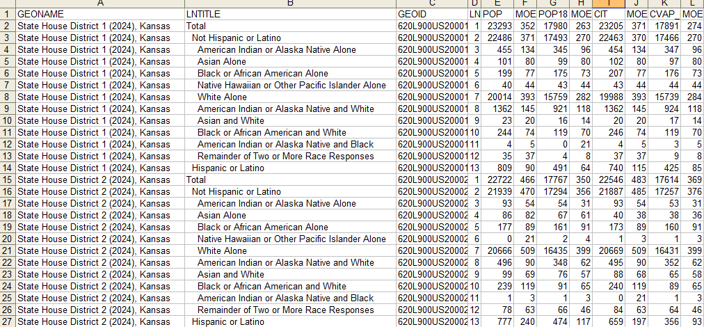 6. ACS 2024 Data Profiles .. goto top Join us in a Web session to learn about using resources on this page. Also learn how you can benefit from other data resources such as the ACS 2024 Data Profiles. Developed as a regular set of annual ACS data, these data provide information on population by age and race, households and social/living arrangements, workforce and more general economic issues, and housing and various attributes of housing to the block group geographic level. We cover these data in the web session and provide information on how to access and use these data. 7. Vintage 2025 Population Estimates and Components of Change .. goto top Join us in a Web session to learn about using resources on this page. Also learn how you can benefit from other data resources such as the Vintage 2025 Population Estimates and Components of Change. Developed and extended annually, these estimates provide a time series of population estimates compoents of change (births, deaths, domestic migration and intertional migration) to the county geographic level. These data tell you how each county and city (and MCD) population is changing. We cover these data in the web session and provide information on how to access and use these data. Example -- Kansas 2020-2025 Population & Components of Change Kansas population increased by 39,446 from 2020 to 2025; 2025: 2,977,720 - 2020: 2,938,274 County level data available in March 2026 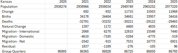 8. TIGER -- digital geography .. goto top Join us in a Web session to learn about using resources on this page. Also learn how you can benefit from other data resources such as the TIGER system. Developed and extended annually, these data are TIGER (Topologically Integrated Geographic Encoding and Referencing) system and represent the U.S. Census Bureau geographic spatial data. The TIGER files include shapefiles for the 119th Congressional Districts, 2024 State Legislative Districts (Upper) and 2024 State Legislative Districts (Lower). We cover these data in the web session and provide information on how to access and use these data. Example -- View of Shawnee County, Kansas State Capitol Showing TIGER file "All lines" using Find tool to locate address See pointer on SW 10th Ave. 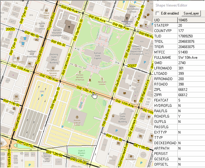 9. Congressional Communities .. goto top Join us in a Web session to learn about using resources on this page. Also learn how you can benefit from other data resources such as Congressional Communities. Developed by the the non-profit Congressional Communities, CCs are geographic areas that sub-divide current Congressional Districts. CCs have subject matter data similar to the ACS Data Profiles. We cover these data (geography and subject matter) in the web session and provide information on how to access and use these data. 10. Data Sources .. goto top The primary sources of data include incumbent administrative data and American Community Survey (ACS). Other data are integrated. 11. Intended Users The intended users include stakeholders, policymakers, candidates, elected officials and others. This version may be used by anyone. No additional staff are required to use or maintain this tool or application. Terms of Use go to top Information provided via this Web page are subject to these terms of use: - they may not distributed except as used in studies or stories. - they are intended for non-business or commercial use. - we request that any usage include reference to ProximityOne and the respective web page. - there is no warranty or guarantee of any type for any aspect of this information. - the user of these data is solely responsible for any use of this information. - more recent data exist for most categories and provided to subscribers. ProximityOne User Group .. goto top Join the ProximityOne User Group to keep up-to-date with new developments relating to metros and component geography decision-making information resources. Receive updates and access to tools and resources available only to members. Use this form to join the User Group. Additional Information .. goto top ProximityOne develops geographic-demographic-economic data and analytical tools and helps organizations knit together and use diverse data in a decision-making and analytical framework. We develop custom demographic/economic estimates and projections, develop geographic and geocoded address files, and assist with impact and geospatial analyses. Wide-ranging organizations use our tools (software, data, methodologies) to analyze their own data integrated with other data. Contact ProximityOne (888-364-7656) with questions about data covered in this section or to discuss custom estimates, projections or analyses for your areas of interest. |
|
|