
|
|
|
Start-up View & Project The CV XE GIS default start-up view is shown below. This view shows patterns of population change by county for the period 2010 to 2020. Color patterns in the legend at left of map show patterns of change. See more about examining county population trends. See more about Geographic Information Systems (GIS) 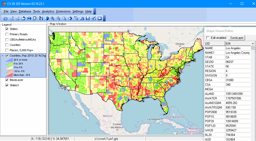 - click graphic for larger view; see details about this GIS Project The view shown in the map window shows the geographic visible extent. The CV XE GIS start-up project has a geographic extent of the United States 48 contiguous states. Use the Zoom/Drag tools to view any region in the U.S. The GIS project is comprised of a set of shapefiles and OpenStreetMap tiling base layer. The GIS project file has defined start-up values/attributes preset for each layer. CV XE GIS projects are named with the file extension "gis". This is the start-up project for all versions of CV XE GIS. About CV XE GIS CV XE GIS is a Windows desktop application and part of a suite of related data analytics tools. • Demographic Economic Data Explorer (DEDE) • CV XE GIS Main • VDA Web GIS • VDA Desktop GIS Getting Started At start-up, CV XE opens the profile file US1.GIS (c:\cvxe\1\us1.gis). For more information about this project, start-up and navigation, see: • CV XE GIS User Guide • CV XE GIS Start-up Project • News & Updates • Creating a Project • Using Existing Projects ProximityOne User Group Join the ProximityOne User Group to keep up-to-date with new developments relating to data resource developments and data analytics. Receive updates and access to tools and resources available only to members. Use this form to join the User Group. Support Using these Resources Learn more about accessing and using demographic-economic data and related analytical tools. Join us in a Data Analytics Lab session. There is no fee for these one-hour Web sessions. Each informal session is focused on a specific topic. The open structure also provides for Q&A and discussion of application issues of interest to participants. Additional Information ProximityOne develops geodemographic-economic data and analytical tools and helps organizations knit together and use diverse data in a decision-making and analytical framework. We develop custom demographic/economic estimates and projections, develop geographic and geocoded address files, and assist with impact and geospatial analyses. Wide-ranging organizations use our tools (software, data, methodologies) to analyze their own data integrated with other data. Follow ProximityOne on Twitter at www.twitter.com/proximityone. Contact us (888-364-7656) with questions about data covered in this section or to discuss custom estimates, projections or analyses for your areas of interest. Contact ProximityOne (888-364-7656) with questions about data covered in this section or to discuss custom estimates, projections or analyses for your areas of interest. |
|
|