|
|
Congressional Districts Main Page Census 2010 CommunityViewer GIS - Applications Gallery - States - School Districts - Counties - Cities/Places - Tracts/Neighborhoods - Census Blocks - ZIP Codes - Urban Areas Demographic-Economic Estimates-Projections GIS Thematic Mapping Visual Analysis Tools Ranking Tables National Scope Demographic Change 2000-2010 - States - Metros - Congressional District - School Districts - Counties - Cities/Places - Census Tracts |
Enacted Redistricting Shapefiles & Geospatial Analysis
This section focuses on access to and use of "enacted redistricting shapefiles." Enacted Redistricting Shapefiles (ERS) are shapefiles that have been developed as the result of legislation enacted by a state or other governmental entity through the redistricting process, based on Census 2010 data, that define/show new political area boundaries. The focus is predominantly on state by state 113th Congress (January 2013) congressional district boundaries and related state house and senate boundaries. Enacted boundary files are obtained from individual states and are in the public domain. In early 2013, the Census Bureau plans to release an official set of these boundary files. The purpose of our process is to provide early access to these boundary files (shapefiles) to facilitate their use between now and mid 2013. Terms of Use. There is no fee to use most of the ERS data made available here. Likewise there is no warranty and limited scope support for their use. These data and related software are for your end-use without redistribution. Others can be directed to this site to obtain the resources for their use. Some custom developed files might be produced and made available on a fee basis (e.g., equivalency files and shapefiles populated with demographic data). State ERS Resources This section is focused on Ohio. We will progressively add shapefiles for other states and attempt to make them available in something of an organized and and standardized structure. Related ERS State Resources: • Illinois - http://proximityone.com/ers_il.htm. Using the Shapefiles. The shapefiles are in decimal degrees and geographic; no projection. They may be used with any software that can process shapefiles. Applications are supported by the ProximityOne CommunityViewer GIS software (CV -- http://proximityone.com/cv.htm). CV is a general purpose GIS software used for reference and pattern analysis applications. CV was used in the Census 2010 LUCA program to facilitate improvement in coverage and accuracy of the Census 2010 TIGER/Line files. CV is used to organize multiple related shapefiles into a GIS project. Map views developed with CV using ERS data create a projected view in a Mercator projection which works well throughout the U.S. To use the GIS project and shapefiles on your computer, proceed with the three following steps. Once the software and project files are installed, you can repeatedly open, view, analyze by just using step 3. 1. Install the No-Fee Version of CommunityViewer (CV) GIS • Use the no-fee version of CV to view/examine/analyze boundaries and patterns. • Run CV Installer -- http://proximityone.com/tracts/cvinstaller.exe (Windows 32/64 OS). • Learn more about CommunityViewer GIS at http://proximityone.com/cv.htm. • Please register here (optional) to receive information on updates ... check "Registering Installation ...". • This step is only performed once. Other state projects and shapefiles work with the installed CV software. 2. Expand the State GIS Project Fileset • Steps shown here are for the Ohio project/shapefiles. • Expand the project files http://proximityone.com/gis/1/oh2011.zip to new folder c:\gis\1 3. Viewing the Geography/Shapefiles and Geospatial Analysis • With CV installed and the GIS Project Fileset expanded, start CV (desktop icon) • Use File>Open and open the project c:\gis\1\oh2011.gpr. Start-up view appears as shown below. • See CommunityViewer user information at http://proximityone.com/cv.htm. Ohio GIS Project and Shapefile Structure and Use The following views and narrative describe/illustrate how the Ohio congressional district and state and house district boundary files can be used with GIS software to visually examine maps and district geography/characteristics of interest. Congressional District Boundaries The following graphic shows the Ohio 2011 enacted congressional districts (green bold semi-transparent boundary with labels) and 111/112th congressional district boundaries (black boundary with yellow labels). County boundaries are shown with gray semi-transparent boundary. The Ohio 2011 enacted shapefile became available 10/26/2011. The Ohio 2011 enacted CD boundary (green) extends into Lake Erie to territorial limit. All 2010 shapefile boundaries have been trimmed at shoreline. Start-up view of GIS project. 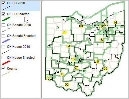 Ohio State and House Boundaries OH House 2010 (black) and enacted (red semi-transparent) 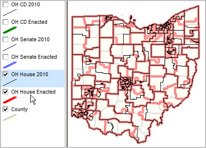 OH Senate 2010 (black) and enacted (blue semi-transparent) 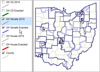 ... illustrating addition of other layers/shapefiles. Zoom in view of OH CD 5 area. 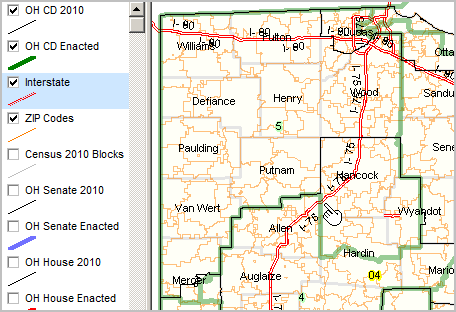 ... illustrating drill-down to intersection. View of CD5/CD4 area showing ZIP Codes (orange w/labels) & census block (gray) detail. Identify tool used to click on and show profile of selected block. This block (pointer) was in CD4 as of Census 2010 and is in CD5 of the enacted CD areas. 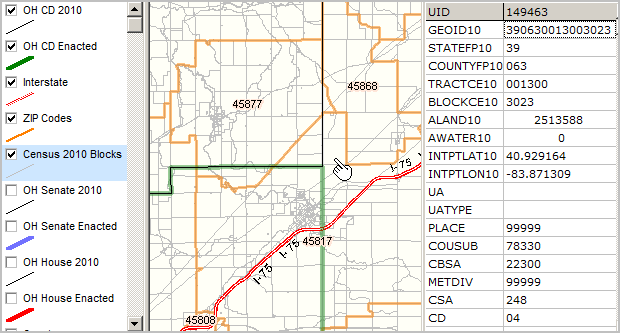 More About the Ohio GIS Project View the above maps on your computer. Zoom in to view specific districts of interest and more. Check/uncheck layers to view only the boundaries of interest. Scope of GIS Project The GIS project fileset includes these shapefiles: • Ohio 111th/112th Congressional Districts (Census Bureau Census 2010) • Ohio 2011 Enacted Congressional Districts (Ohio Secretary of State) • Ohio 2010 vintage Senate districts (Census Bureau Census 2010) • Ohio 2010 vintage House districts (Census Bureau Census 2010) • Ohio 2011 Enacted Senate districts (Ohio Secretary of State) • Ohio 2011 Enacted House districts (Ohio Secretary of State) Next Steps Integrating subject matter and making thematic pattern maps. Viewing city/place layers. Viewing ZIP code layers. Additional Information Proximity develops geodemographic-economic data and analytical tools and helps organizations knit together and use diverse data in a decision-making and analytical framework. We develop custom demographic/economic estimates and projections, develop geographic and geocoded address files, and assist with impact and geospatial analyses. Wide-ranging organizations use our tools (software, data, methodologies) to analyze their own data integrated with other data. Contact Proximity (888-364-7656) with questions about data covered in this section or to discuss custom estimates, projections or analyses for your areas of interest. | |||||||||
|
|
