
|
|
|
.. using Federal GeoStatistical data .. focus on sites and local/regional areas .. interpretative data analytics; tools, data & methods March 2025 .. Federal geostatistical data provide a wide range of housing-related data such as size, age and type of homes; home values, rents and mortgages, construction, prices and more. These housing data are important to private and public sector stakeholders. Together, these data provide a comprehensive picture of housing, that facilitate data-driven decision-making. This section provides insights as to what relevant data are available, how to access the data, how to organize the data, how to use the data for collaboration and decision-making, Organize these data by geography, time-frame and subject matter into a plan or study. We provide how-to guides and examples. This section is initially focused on Manhattan, KS as a case study. We initially show a few lay-of-the-land graphics. These graphics have been developed using a VDA (Visual Data Analytics) GIS (Geographic Information System) project which is reviewed following the introductory graphics.
This section is still under development. Join us in the weekly
web meeting sessions to learn more about using the tools and data
referenced in this section.
Topics • 01 Manhattan, KS Area Housing Study Lay of the Land • 02 Manhattan, KS Area Demographic-Economic Characteristics • 03 Using the Housing Study Project with VDAGIS -- interactive mapping and geospatial analysis • 04 About the Housing Study Project • 05 Using DEDE to Extract/Integrate other Data • 06 Adding Other Layers/Data to the Project • 07 About VDAGIS • 08 Terms of Use Manhattan, KS Housing Study Lay-of-the-Land The following graphic shows Manhattan with an orange fill pattern in context of the state. Counties are shown with a black boundary and congressional districts are shown with a dark brown boundary. 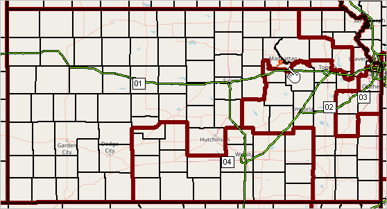 The next graphic shows a further zoom-in showing Manhattan in context of Riley County, KS and Congressional District (CD) KS-01. Manhattan is mostly contained within Riley County and entirely contained within CD KS-01. 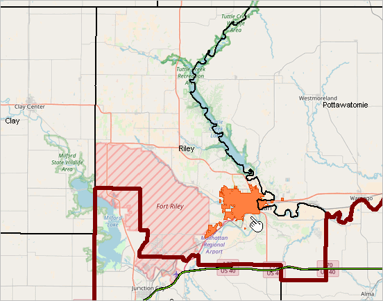 The next graphic shows selected Metropolitian Statistical Areas (MSAs) part of Core-Based Statistical Areas. Manhattan is comprised of three counties. 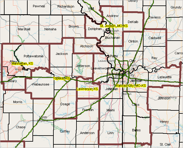 This graphic shows patterns of how and why population change by county occurred between 2020 and 2024. Click graphic for larger view. 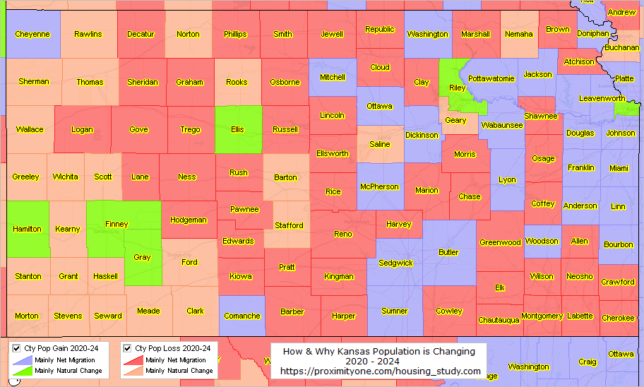 Manhattan GeoDemographic Overview .. scroll section .. goto top The Manhattan city, KS Census-sourced model-based population estimate changed from 54,158 (7/1/20) to the most recent 2023 estimate of 53,682. The 2023 American Community Survey (ACS2023) 5-year total housing units was 24,334. These estimates are centric to 2021; there is no Census sourced 2023 estimate of total housing units as the city of Manhattan fell below the population threshold of 65,000, required for the ACS 2023 1-year estimates. The metro census-sourced model-based population estimates and components of change are shown below.
Popest24 = Popest23 + Births24 - Deaths24 + IntlMig24 + DomMig24 + Residual24
  134892 =   133371 +     1916 -      831 +      1318 -      879 -          3

CBSA    STCTY   NAME                    Popest20  Popest21  Popest22  Popest23  Popest24
31740           Manhattan, KS MSA         134198    133885    133474    133371    134892
31740   20061   Geary County, KS           36766     36131     35525	 35192	   35459
31740   20149   Pottawatomie County, KS    25421     25884     26331     26506     26876
31740	20161	Riley County, KS           72011     71870     71618     71673     72557

                Births21  Births22  Births23  Births24  Deaths21  Deaths22  Deaths23  Deaths24
                    2109      2012      1951      1916       885       960       854       831
                    1039       922       868       856       264       287       273       279
                     371       384       386       380       216       216       188       192
                     699       706       697       680       405       457       393       360

               IntlMig21 IntlMig22 IntlMig23 IntlMig24  DomMig21  DomMig22  DomMig23  DomMig24
                     107       532      1154      1318     -1629     -2007     -2391      -879
                      24       102       346       388     -1378     -1377     -1284      -686
                       2        22        66        79       299       271       -88       104
                      81       408       742       851      -550      -901     -1019      -297
Manhattan-Kansas Demographic Comparative Insights .. goto top.. using the Demographic Analytics tool • Narrative Comparative Analysis Report • Tabular Comparative Analysis Report Manhattan, ACS 2023 5-Year Housing Characteristics .. scroll section .. goto top
2024 Q1-Q3 Establishments, Employment, Earnings by Type of Business For Riley County, KS .. goto top each row shows attributes for Riley County, KS iterated by owner type, year/quarter and type of business more about these data .. more about related products click ShowAll button between queries. click column header to sort; click again to sort other direction. Interactive Table Usage Notes Operations • Click ShowAll between queries/filters. Items in Table GeoId own_code industry_code agglvl_code size_code Year Qtr Disc code area_title own_title Industry agglvl_title size_title Qtr Estabs M1 Emp M2 Emp M3 Emp Total Qtrly Wages Taxable Qtrly Wages Qtrly Contr Avg Wkly Wage Location Quotient lq_disclosure_code lq_qtrly_estabs_count lq_month1_emplvl lq_month2_emplvl lq_month3_emplvl lq_total_qtrly_wages lq_taxable_qtrly_wages lq_qtrly_contributions lq_avg_wkly_wage Over the Year oty_disclosure_code oty_qtrly_estabs_count_chg oty_qtrly_estabs_count_pct_chg oty_month1_emplvl_chg oty_month1_emplvl_pct_chg oty_month2_emplvl_chg oty_month2_emplvl_pct_chg oty_month3_emplvl_chg oty_month3_emplvl_pct_chg oty_total_qtrly_wages_chg oty_total_qtrly_wages_pct_chg oty_taxable_qtrly_wages_chg oty_taxable_qtrly_wages_pct_chg oty_qtrly_contributions_chg oty_qtrly_contributions_pct_chg oty_avg_wkly_wage_chg oty_avg_wkly_wage_pct_chg Using the Housing Study Manhattan Project with VDAGIS .. goto top .. the Manhattan housing study project interactive iVDA start-up view is shown in the iframe below. .. Manhattan city is shown with the salmon color fill pattern. .. see more about iVDA features and operations. .. the first thing to do when using iVDA is to have an objective. .. objective: view humber of housing units by block group. .. show/examine number/characteristics of housing units .. click the checkbox on the "BG HsgUnits A23" layer in legend panel at left of map. - the map window refreshes showing the number of housing units by block group. - these data are based on the 2023 American Community Survey 5-year estimates (ACS2023). .. show/examine attributes of a block group (BG) .. click a BG in map; profile shows in lower left panel. .. the section being viewed is located at https://proximityone.com/housing_study.htm#ivda Optionally use this full screen view of the housing study project About the Housing Study Project .. goto top The Housing Study Manhattan Project is not a housing plan. It is a set of Federal GeoStatistical Data organized to illustrate sources and uses of these data that can facilitate development of a plan or study that might integrate non-Federal sourced data. Design The Housing Study resource does not have an executive summary, projected trends nor conclusions and recommendations. It is a set of integrated resources that might be used to develop that scope of information. The design of the housing study project involves organizing a set of geostatistical layers focused on small area geography but conveyed on a state or national scale. A few point layers are included (K-12 schools, banks, hospitals). Boundary layers include states, metros, congressional districts, congressional communities, state legislative districts, counties, urban areas, school districts, townships, tracts, block groups and census blocks. The interstate highway layer is included as a line layer; other road features and transporation features could be included. A raster graphics topology layer is included from OpenStreets Maps. Structure and Content Layers/Data Resources Used in the Housing Study Project Most of the project layer geographies listed below are based on Census Bureau TIGER-based geography or shapefiles. Without the TIGER data we would not be able to assemble this integrated subject matter - geography view. The TIGER geospatial data uniquely enables a standardized view of these characteristics for anywhere in the U.S. A similar housing study can be developed/examined for any area by relocating (zoom/pan) the map window and/or setting seacrhes/queries to those locations. The following list of layers is also shown in the VDAGIS legend panel. United States States Interstate Hospitals K-12 Schools FDIC Banks Congressional Districts St Leg Dist House St Leg Dist Senate Congressional Communities CBSA/MSA Counties Urban Areas City/Place Name City/Place Boundary Cities/Places School Districts Townships Tract Code Tracts LMI Label Tracts LMI MFI Tract/MSA% Tracts Rental Hsg Cost Burdened .. not active this version Tracts $MHI Tracts $MHV BG HU Blt 2020+ A23 BG HsgUnits A23 Affordable Housing Areas (BGs) .. not active this version Blocks Blocks, GrpQtrs Blocks HsgUnits Chg 20-24 Roads 20161 BaseLayer1 States1 Layers/Federal GeoStatistical Data Resources that Could be Added to the Housing Study Project County - BEA REIS County - BLS QCEW County - Census CBP County/Place - Census Building Permits Census Tracts - HUD Qualified Census Tracts Census Tracts - Housing Price Index Using DEDE to Extract/Integrate other Data .. goto top Use the Demographic-Economic Data Explorer (DEDE) to extract other Federal GeoStatistical Data to add to a housing study. ACS 2023 api_items_acs23_base_emp.txt DEDE Subject Matter Items File B01001_001E TotPopA23 Total Population B01001_002E MPopA23 Male B01001_026E FPopA23 Female B02001_002E White1A23 White alone B02001_003E Black1A23 Black or African American alone B02001_004E AIAN1A23 American Indian and Alaska Native alone B02001_005E Asian1A23 Asian alone B02001_006E NHOPI1A23 Native Hawaiian and Other Pacific Islander alone B02001_007E Other1A23 Some other race alone B02001_008E MultiA23 Two or more races B03002_012E HispA23 Hispanic (any race) B01001_003E A0004MA23 Male: Under 5 years B01001_004E A0509MA23 Male: 5 to 9 years B01001_005E A1014MA23 Male: 10 to 14 years B01001_006E A1517MA23 Male: 15 to 17 years B01001_027E A0004FA23 Female: Under 5 years B01001_028E A0509FA23 Female: 5 to 9 years B01001_029E A1014FA23 Female: 10 to 14 years B01001_030E A1517FA23 Female: 15 to 17 years B09020_001E Pop65upA23 Population 65 years and over B11002_001E PopHHA23 Population in Households B11001_001E HHA23 Total Households B11001_002E FamA23 Family Households B15002_001E Pop25upA23 Population 25 years and over B15002_011E EAHSMA23 Male: High school graduate (includes equivalency) B15002_015E EABMA23 Male: Bachelor's degree B15002_028E EAHSFA23 Female: High school graduate (includes equivalency) B15002_032E EABFA23 Female: Bachelor's degree B29001_001E VATOTA23 Total Citizen, Voting-Age Population B25003_001E TotHsgA23 Total housing units B25003_002E OwnOccA23 Owner occupied units B25003_003E RntOccA23 Renter occupied units B25002_003E VacantA23 Vacant units B25105_001E MDMTHHCA23 Median Monthly Housing Costs (Dollars) B19013_001E MHIA23 Median Household Income B19113_001E MFIA23 Median Family Income B25077_001E MHVA23 Median housing value B25064_001E MdRentA23 Median gross rent B19083_001E GiniA23 Gini Index of Income Inequality B23025_001E POP16UPA23 Population 16 years and over B23025_002E LFA23 In labor force B23025_003E CLFA23 Civilian labor force B23025_004E EMPA23 Employed B23025_005E UNEMPA23 Unemployed B23025_006E AFA23 Armed Forces B23025_007E NILFA23 Not in labor force NAME NAME NAME Adding Other Layers/Data to the Project .. goto top Use other Visual Data Analytics (VDA) Geographic Information System (GIS) tools with the housing project shown above as used with iVDA. Add other layers/data using: • VDA Desktop (VDAD - Windows) offering maximum speed, processing features, maximum security • VDA Web (VDAW4) - like iVDA with full screen viewer and ability to add layers Adding Data (from any source) using VDAW4 -- requires only a web browser Select the Housing Study .. the application opens Adding Streets Layer for Riley County, KS Add your own shapefile/data to an existing project to view/analyze your data with other existing layers/data. Analytical opportunities are unlimited! Use any existing project to upload layers. With project open, use File>Upload and proceed as described here. Integrating Detailed Streets/Roads .. click to expand/collapse This section shows how to add 2024 TIGER detailed roads ("edges") for a county. Riley County, KS is used here as an example. These are detailed road segments covering Riley County, KS based on the 2024 TIGER edges shapefile. Typically these are intersection to intersection, but often comprised of shorter connected segments. Step 1. Extract the Riley County, KS (20161) edges shapefile to c:\vdauploads .. https://www2.census.gov/geo/tiger/TIGER2024/EDGES/tl_2024_20161_edges.zip .. it is suggested that all VDA upload files be kept in one folder, such as C:\vdauploads, and not contain other files. Note: get the edges shapefile for any county from this set of links. .. the counties are organized by state+county FIPS code .. to use another county, replace 20161 in the following the state+county edges file that is downloaded. Step 2. Delete all unzipped files in c:\vdauploads except these: tl_2024_20161_edges.shp tl_2024_20161_edges.shx tl_2024_20161_edges.dbf Step 3. Develop the INI file Copy the 11 lines below, paste into Notepad (any text editor) and save as c:\vdauploads\tl_2024_20161_edges.shp.ini .. when uploading a file that has large, detailed objects displayed, set Active=NO .. otherwise set Active=YES .. if Active=No, the layer will show as unchecked and not display in the Map Window Active=NO Caption=20161 Roads CodePage=932 CS.EPSG=4269 Ground=OnDem Label.Alignment=FOLLOW Label.Color=$10101 Label.Field=FULLNAME Label.OutlineWidth=2 Query=roadFLG='Y' Visible=YES .. the spelling/characters used in file names must match exactly. .. the Riley County roads (edges) shapefile has state county code 20161 Step 4. Zip (for example using Winzip) these four files to the new file c:\vdauploads\tl_2024_20161_edges.zip Step 5. With VDAW4 running using the Housing Project (VDAW4 using the Housing Study), use File>Userfile Upload Layer from the Main Menu bar to start the upload. Choose the file "c:\vdauploads\tl_2024_20161_edges.zip" and proceed to upload. Large zip files may require several minutes to complete; wait for a message and do not click upload again. Close the upload form when done. The following view shows the "20161 Roads". To obtain a view similar, enter "Kansas State University" in searchbar and press enter. 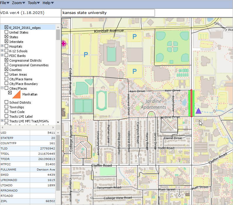
End of section. About VDAGIS .. goto top The Visual Data Analytics (VDA) Geographic Information System (GIS) is a suite of tools and data that you can use to examine multi-sourced geographic, demographic and economic data. VDAGIS resources are developed and maintained by Warren Glimpse, ProximityOne (Alexandria, VA) and Takashi Hamilton, Tsukasa Consulting (Osaka, Japan). See more about VDAGIS. Add your own data. Terms of Use .. goto top There is no warranty regarding any aspect of any information presented in this section. The user is solely responsible for any use of this section. Support Using these Resources .. goto top Learn more about accessing and using demographic-economic data and related analytical tools. Join us in a web meeting session. There is no fee for these one-hour Web sessions. Each informal session is focused on a specific topic. The open structure also provides for Q&A and discussion of application issues of interest to participants. ProximityOne User Group Join the ProximityOne User Group to keep up-to-date with new developments relating to geographic-demographic-economic decision-making information resources. Receive updates and access to tools and resources available only to members. Use this form to join the User Group. Additional Information ProximityOne develops geographic-demographic-economic data and analytical tools and helps organizations knit together and use diverse data in a decision-making and analytical framework. We develop custom demographic/economic estimates and projections, develop geographic and geocoded address files, and assist with impact and geospatial analyses. Wide-ranging organizations use our tools (software, data, methodologies) to analyze their own data integrated with other data. Contact ProximityOne (888-364-7656) with questions about data covered in this section or to discuss custom estimates, projections or analyses for your areas of interest. |
|
|