|
|
America's Urban Agglomerations
December 2022. Urban agglomerations are contiguous areas of continuously developed urban territories.
Urban agglomeration data have typically not been reported by the Census Bureau,
the rationale being that they become progressively meaningless the larger the urban agglomeration area becomes.
It remains that urban agglomerations are of interest. New information surfaces as the Census
Bureau revises definitions relating to the urban geography for Census 2020
(results being finalized in 2023).
United States in Global Perspective
The United Nations reports global urban agglomeration data
by country (a downloadable xls file within this page and as of 2018).
For 2035, Delhi, India at 43 million and Toyko, Japan at 36 million are projected to be the largest based on population.
They project New York to be the largest U.S. agglomeration at 21 million in 2035.
At issue are the geographic boundaries for each area; there is no global standard definition for metros nor
urban agglomeration areas. See
alternative notes on urban agglomeration.
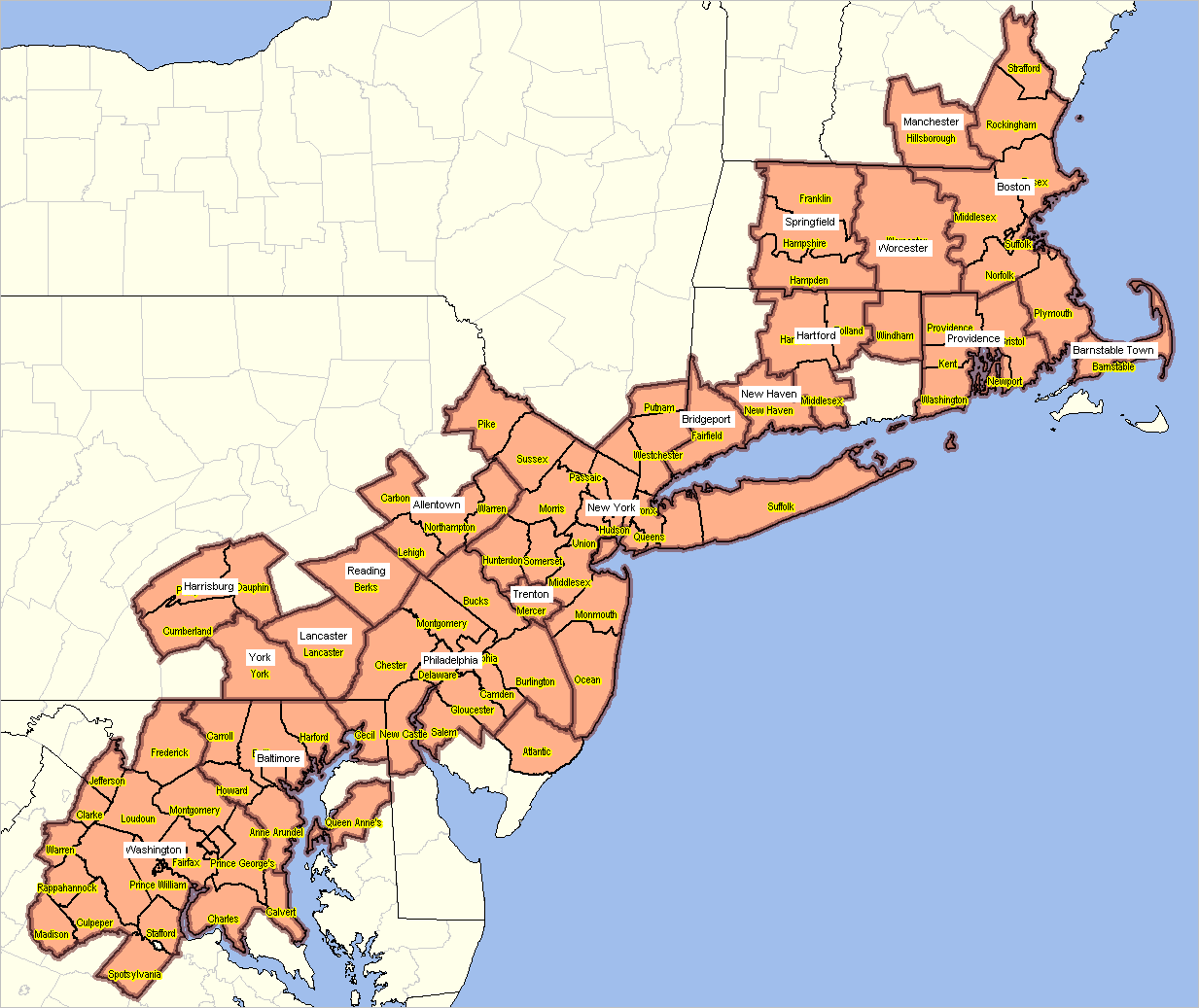
Census Defines New "Megalopolis"
In December 2022, the Census Bureau developed
this story
featuring a Megalopolis extending from New Hampshire to Washington, DC area.
Examine the Megalopolis area by county and subcounty area using
VDA Web GIS as illustrated in the following graphic.
In the following view, 2020 CBSAs
are shown with bolded brown semi-transparent boundaries. The 103 component counties are shown with bold black boundaries
and orange fill pattern.
The Megalopolis attribute has been coded as a selectable attribute into the "County1" layer in the
MetroDynamics GIS project.
.. read details in web page for description/meaning of legend.
.. click graphic for larger view with metro and county names.
Potential Agglomeration Areas
Based on Census 2000 Urbanized Areas (UAs), the
Census Bureau has identified 52 potential agglomerations consisting of
multiple and currently separate UAs. These agglomerations contain UAs that
currently are contiguous as well as some that are in close proximity to each other
and that potentially could form a continuous agglomeration when areas
are redefined based on 2020 Census data.
Agglomeration Areas
A table presented below lists the potential agglomerations, the
component UAs, and the American Community Survey estimated population for the 2010 Urbanized Areas.
| New York-Philadelphia-Connecticut |
New York-Newark, NY-NJ-CT; Philadelphia, PA-NJ-DE-MD; Allentown-Bethlehem, PA-NJ; Lancaster, PA; Pottstown, PA; Reading, PA; Trenton, NJ; Hightstown, NJ; Vineland, NJ; Poughkeepsie-Newburgh, NY; Bridgeport-Stamford, CT; Danbury, CT-NY; Hartford, CT; New Haven, CT; Norwich-New London, CT; Waterbury, CT; Springfield, MA-CT |
29,028,337 |
| |
| Los Angeles-Riverside-San Bernardino |
Los Angeles-Long Beach-Santa Ana, CA; Riverside-San Bernardino, CA; Camarillo, CA; Hemet, CA; Oxnard, CA; Santa Barbara, CA; Santa Clarita, CA; Simi Valley, CA; Temecula-Murrieta, CA; Thousand Oaks, CA |
15,492,749 |
| |
| Chicago-Kenosha-Racine-Round Lake Beach |
Chicago, IL-IN; Kenosha, WI; Round Lake Beach-McHenry-Grayslake, ILWI; Racine, WI | 8,944,789 |
| |
| Boston-Providence-Worcester |
Boston, MA; Providence, RI-MA; Worcester, MA-CT; Barnstable Town, MA; Leominster-Fitchburg, MA; New Bedford, MA; Dover-Rochester, NH; Manchester, NH; Nashua, NH; Portsmouth, NH |
6,692,295 |
| |
| Baltimore-Washington |
Aberdeen, MD; Baltimore, MD; Washington, DC-VA-MD; St. Charles, MD |
6,585,315 |
| |
| San Francisco-Oakland-San Jose |
San Francisco-Oakland, CA; San Jose, CA; Antioch, CA; Concord, CA; Livermore, CA; Vallejo, CA |
5,870,212 |
| |
| Dallas-Fort Worth | Dallas-Fort Worth-Arlington, TX; Denton-Lewisville, TX; McKinney, TX | 5,006,527 |
| |
| Houston-Texas City | Houston, TX; Texas City, TX; Galveston, TX; The Woodlands, TX | 4,599,176 |
| |
| Detroit-Ann Arbor-Port Huron | Detroit, MI; Ann Arbor, MI; Port Huron, MI; South Lyon-Howell-Brighton, MI | 4,326,040 |
| |
| Atlanta-Gainesville . | Atlanta, GA; Gainesville, GA | 4,196,670 |
| |
| San Juan-Aguadilla-Ponce | San Juan, PR; Aguadilla-Isabela-San Sebastia�n, PR; Arecibo, PR; Fajardo, PR; Florida-Barceloneta-Bajadero, PR; Guayama, PR; Juana Di�az, PR; Mayagu�ez, PR; Ponce, PR; San Germa�n-Cabo Rojo-Sabana Grande, PR; Yauco, PR | 3,591,491 |
| |
| Phoenix-Mesa-Avondale | Phoenix-Mesa, AZ; Avondale, AZ | 3,328,183 |
| |
| San Diego-Mission Viejo | San Diego, CA; Mission Viejo, CA | 3,273,255 |
| |
| Seattle-Bremerton-Marysville | Seattle, WA; Bremerton, WA; Marysville, WA | 3,206,057 |
| |
| Cleveland-Akron-Canton-Lorain-Elyria | Cleveland, OH; Akron, OH; Canton, OH; Lorain-Elyria, OH | 2,722,194 |
| |
| Tampa-St. Petersburg-Lakeland-Winter Haven | Tampa-St. Petersburg, FL; Lakeland, FL; Winter Haven, FL; Brooksville,
FL | 2,719,812 |
| |
| |
| Cincinnati-Dayton-Middletown | Cincinnati, OH-KY-IN; Dayton, OH; Middletown, OH; Springfield, OH | 2,426,070 |
| |
| Denver-Boulder-Longmont | Denver-Aurora, CO; Boulder, CO; Longmont, CO; Lafayette-Louisville, CO | 2,339,587 |
| |
| St. Louis-Alton | St. Louis, MO-IL; Alton, IL | 2,184,037 |
| |
| Orlando-Ocala-Kissimmee | Orlando, FL; Ocala, FL; Kissimmee, FL; Lady Lake, FL; Leesburg-Eustis,
FL | 1,814,061 |
| |
| Pittsburgh-Uniontown-Monessen | Pittsburgh, PA; Uniontown-Connellsville, PA; Monessen, PA | 1,792,892 |
| |
| Kansas City-Lee�s Summit | Kansas City, MO-KS; Lee�s Summit, MO | 1,468,106 |
| |
| Salt Lake City-Ogden-Layton | Salt Lake City, UT; Ogden-Layton, UT | 1,439,004 |
| |
| Indianapolis-Anderson | Indianapolis, IN; Anderson, IN | 1,367,392 |
| |
| Charlotte-Gastonia-Concord | Charlotte, NC-SC; Gastonia, NC; Concord, NC; Rock Hill, SC | 1,282,839 |
| |
| Nashville-Murfreesboro | Nashville-Davidson, TN; Murfreesboro, TN | 983,180 |
| |
| Raleigh-Durham | Raleigh, NC; Durham, NC | 974,582 |
| |
| Palm Bay-Melbourne-Titusville-Vero Beach | Palm Bay-Melbourne, FL; Titusville, FL; Vero Beach-Sebastian, FL; Port
St. Lucie, FL | 938,675 |
| |
| Oklahoma City-Norman | Oklahoma City, OK; Norman, OK | 875,469 |
| |
| |
| |
| Honolulu-Kailua (Honolulu County) | Honolulu, HI; Kailua (Honolulu County), HI | 854,430 |
| |
| McAllen-Harlingen | McAllen, TX; Harlingen, TX | 753,816 |
| |
| Greensboro-High Point-Winston-Salem | Greensboro, NC; High Point, NC; Winston-Salem, NC | 741,457 |
| |
| Sarasota-Bradenton-Punta Gorda | Sarasota-Bradenton, FL; North Port-Punta Gorda, FL | 726,695 |
| |
| Bonita Springs-Naples-Cape Coral | Bonita Springs-Naples, FL; Cape Coral, FL | 659,480 |
| |
| Harrisburg-York-Lebanon | Harrisburg, PA; York, PA; Lebanon, PA | 651,160 |
| |
| Greenville-Spartanburg | , SC; Spartanburg, SC; Mauldin-Simpsonville, SC | 568,737 |
| |
| Pensacola-Fort Walton Beach | Pensacola, FL-AL; Fort Walton Beach, FL | 506,715 |
| |
| Stockton-Lodi-Manteca | Stockton, CA; Lodi, CA; Manteca, CA | 501,544 |
| |
| Spokane-Coeur d�Alene | Spokane, WA-ID; Coeur d�Alene, ID | 441,042 |
| |
| Boise City-Nampa | Boise City, ID; Nampa, ID | 422,639 |
| |
| Modesto-Turlock . | Modesto, CA; Turlock, CA | 414,571 |
| |
| South Bend-Elkhart | South Bend, IN-MI; Elkhart, IN-MI | 408,373 |
| |
| Salinas-Santa Cruz-Watsonville | Salinas, CA; Santa Cruz, CA; Watsonville, CA | 388,071 |
| |
| Charleston-Huntington | Charleston, WV; Huntington, WV-KY-OH | 354,568 |
| |
| Santa Rosa-Petaluma | Santa Rosa, CA; Petaluma, CA | 351,752 |
| |
| Rockford-Beloit | Rockford, IL; Beloit, WI-IL | 337,215 |
| |
| Atlantic City-Wildwood | Atlantic City, NJ; Wildwood-North Wildwood-Cape May, NJ | 280,698 |
| |
| Appleton-Oshkosh | Appleton, WI; Oshkosh, WI | 263,213 |
| |
| Beaumont-Port Arthur | Beaumont, TX; Port Arthur, TX | 249,716 |
| |
| Macon-Warner Robins | Macon, GA; Warner Robins, GA | 232,780 |
| |
| Kingsport-Johnson City | Kingsport, TN�VA; Johnson City, TN | 208,241 |
| |
| Fairfield-Vacaville | Fairfield, CA; Vacaville, CA | 207,859 |
Support Using these Resources
Learn more about accessing and using demographic-economic data and related analytical tools.
Join us in a Data Analytics web session.
There is no fee for these one-hour Web sessions.
Each informal session is focused on a specific topic.
The open structure also provides for Q&A and discussion of application issues of interest to participants.
ProximityOne User Group
Join the ProximityOne User Group
to keep up-to-date with new developments relating to geographic-demographic-economic decision-making information resources.
Receive updates and access to tools and resources available only to members.
Use this form to join the User Group.
Additional Information
ProximityOne develops geographic-demographic-economic data and analytical tools and helps organizations knit together and use diverse data in a decision-making and analytical framework. We develop custom demographic/economic estimates and projections, develop geographic and geocoded address files, and assist with impact and geospatial analyses.
Wide-ranging organizations use our tools (software, data, methodologies) to analyze their own data integrated with other data.
Follow ProximityOne on Twitter at
www.twitter.com/proximityone.
Contact ProximityOne (888-364-7656) with questions about data covered in this section or to discuss custom estimates, projections or analyses for your areas of interest.
|