
|
|
|
-- Visual Data Analytics (VDA) Geographic Information System (GIS) -- Using VDA Desktop GIS via Remote Desktop Service -- accessing the Federal GeoStatistical System .. and much more The Visual Data Analytics (VDA) Geographic Information System (GIS) is a collection of GIS tools and datasets. VDA GIS tools started with development of the VDA Web GIS. VDA GIS tools may now be accessed used in many computer environments. VDA GIS Remote Desktop Service The VDA GIS Remote Desktop Service (VDA RDS) enables the user to run the VDA Desktop GIS from the VDA RDS server. This is enabled through remote desktop operation available for most operating systems and platforms, including hand-held computing devices. Microsoft and Apple each have a product called "Remote Desktop." Patterns of Population Change by Congressional District The following view shows patterns of population change by congressional district. This is an illustrative view of how you can use the VDA GIS Remote Desktop Service. 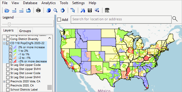 About this Section & VDA GIS Framework .. goto top This document provides an overview of the using the VDA Desktop GIS via the VDA GIS Remote Desktop Service. VDA GIS resources have been developed and are maintained by Warren Glimpse/ProximityOne/Alexandria, VA USA and Takashi Hamilton/Tsukasa/Osaka, Japan. E-mail us or call (888-364-7656) with questions/help. VDA Desktop GIS The VDA Desktop GIS (VDAD) is a Windows-based GIS software product that can be installed on Windows computers. Connecting with the VDA GIS Remote Desktop Service .. goto top VDAD may be accessed/used via our Windows server using the Remote Desktop Service (RDS). On a Windows computer, this can be done by starting Remote Desktop (type remote desktop into the lower left search bar). Starting Remote Desktop, a new window is displayed as shown below. 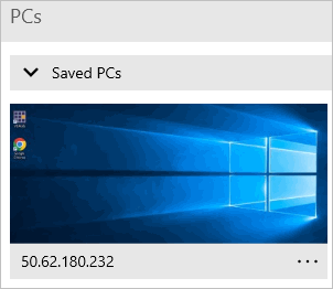 The screen may be empty/blank until you "select a PC". Select the VDA RDS by clicking "+ Add" at the top right. Next select PC. A new form appears as shown below. 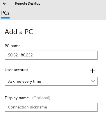 Enter the IP address 50.62.180.232 as shown in the graphic. Then click Save at the bottom of the form. From now on, the VDA RDS web server will show as available. Login to VDAGIS Remote Desktop Service .. goto top Now click the Saved PCs with the IP address 50.62.180.232 shown above. The Login form appears as shown below. Enter your personal username and password. Request a VDA RDS username and password here. Click the checkbox "Requesting VDA GIS RDS userid". The VDA GIS RDS username and password will be emailed to you. 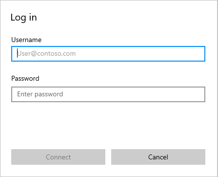 RDS Interface .. Start VDA Desktop GIS .. goto top When the RDS interface appears, click the VDAGIS icon to start VDAD: VDAD starts as if running on a Windows desktop. VDA GIS Interface .. Select Server Project .. goto top When the VDAD interface appears, optionally open (File>Open Server Project) a server project: 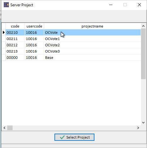 Using VDAD via RDS The VDAD RDS start-up view shows the "Base" project with a map winodw view of the U.S. by county: 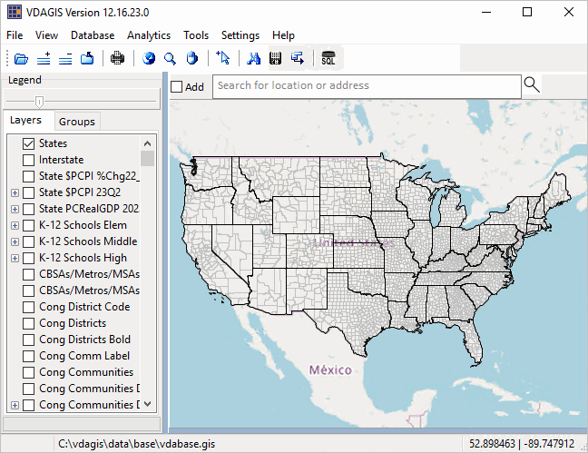 Application Examples 01 -- Examine Thematic Pattern: How & Why Population by County Changed; 2020-2022 02 -- Find a Congressional Community Using Tool>Find Shape 03 -- Mapping Congressional Communities & 118th Congressional Districts App 01 -- Examine Thematic Pattern: How & Why Population by County Changed; 2020-2022 .. goto top Consider an application where you want to examine patterns of how and why population by county changed; 2020-2022 using geospatial methods. Steps below illustrate use of the VDAD RDS .. with VDAD RDS running with start-up view & in legend panel at left 1. uncheck layer Counties1 2. check on the Cty Population Gain 2020-2022 layer 3. check on the Cty Population Loss 2020-2022 layer The patterns are now shown in the map window. 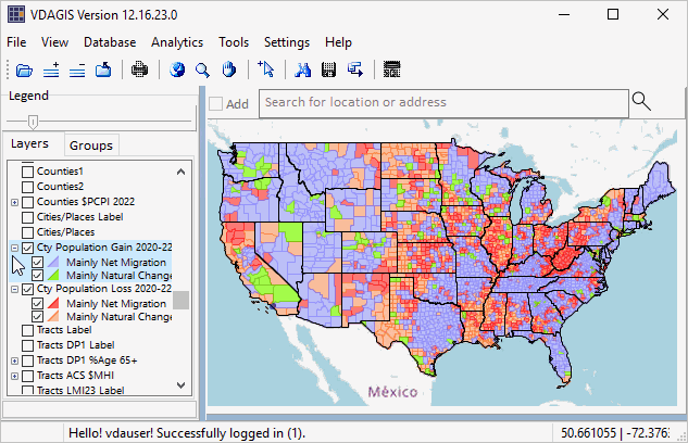 End of App 01. App 02 -- Find a Congressional Community Using Tool>Find Shape .. goto top Consider an application where you want to find a congressional community (CC) based on the CC geocode. CC geocodes are 7 characters SSCDCCC, where CC is the state FIPS code, CD is the 118th congressional district code, and CCC is the CC within that CD. In this example CC 0647001 is used. The Find Shape operation illustrated in this application can be used to find a geography (geocode) in any type of layer; e.g., census tract or congressional district. Steps below illustrate use of the VDAD RDS .. with VDAD RDS running with start-up view .. select Tools>Find Shape from the Main Menu bar. .. the Find Shape form appears as shown in graphic below In the Find Shape form, folow these steps: 1. select the layer in the dropdown 2. select the field in the dropdown 3. select the logical operation in the dropdown 4. select the target value (the CC geocode in this example) 5. click Search button. If found, the selected geography is shown as crosshatched in the map window. 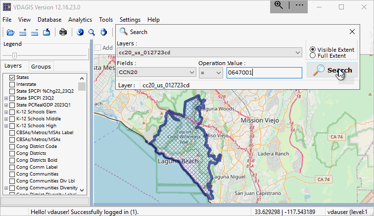 End of App 02. App 03 -- Mapping Congressional Communities & 118th Congressional Districts .. goto top Consider an application where you want to view a congressional community in context of the corresponding congressional district. Steps below illustrate use of the VDAD RDS .. with VDAD RDS running with start-up view .. enter a ZIP code, location or address in the Search bar and press enter. .. to illustrate, enter "Laguna Beach" (no quotes, in Orange County, CA) and press enter A zoom-in then shows a blue triangle marker at the location. .. in the legend panel at left, click checkbox on for each of these layers: - Cong District Code (displays Congressional District code in map) - Cong District Bold (displays Congressional Districts with bold boundary in map) - Cong Comm Label (displays Congressional Community labels/codes in map) - Cong Communities (displays Congressional Communities with black CC boundaries in map) .. navigate to preferred view (e.g., pan or zoom in/out) .. use a screen capture tool to capture view meeting application objective Pointer in graphic shows the boundary (bold) for CA CD 47 and is within CC 0647001. See other CCs comprising this CD. View a list of the component CCs with associated demographics in this interactive table. .. click Find CD button below table. 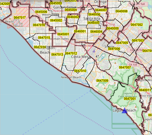 End of App 03. Support Using these Resources .. goto top Learn more about accessing and using demographic-economic data and related analytical tools. Join us in a Data Analytics Web Session. There is no fee for these Web sessions. Each informal session is focused on a specific topic. The open structure also provides for Q&A and discussion of application issues of interest to participants. |
|
|