

|
|
|
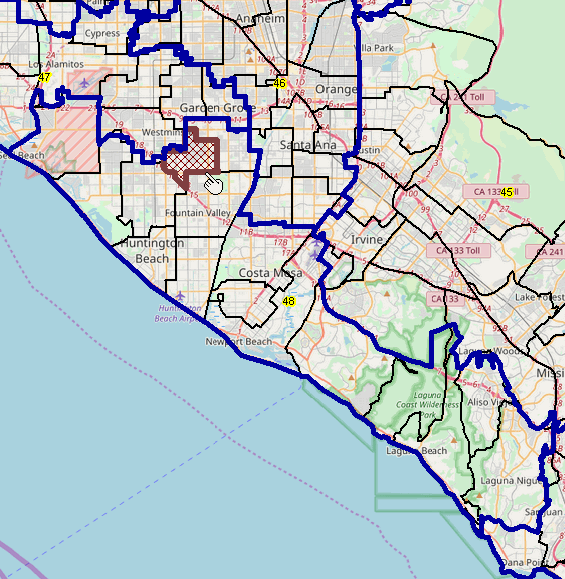
-- developing insights into congressional communities and districts -- geographic, demographic, economic characteristics, patterns and trends Visual analysis using interactive maps is often the most effective and fastest way to answer many types of geodemographic questions. For Congressional Communities (CC) interactive mapping can help with questions like: • Where is my Congressional Community (CC) or congressional district? • How to view the "lay-of-the-land" of CCs and related congressional districts? • How to examine the demographic-economic composition and trends of a CC? • How to relate/compare a CC with other CCs in the Congressional District? Communicating and collaborating with others can produce better results using maps than using tabular data alone. Congressional Community Geography. Congressional Communities (CCs) are subdivisions of congressional districts developed by Congressional Communities. The following view illustrates the structure of a CC (bold brown boundary) on the left. This is a view of CC 0648010 -- California (06) Ccngressional District (48) CC 010. CCs are comprised of contiguous block groups (BGs). BGs are shown with black boundaries with a 12-character, Census Bureau assigned, BG code that uniquely identifies the BG among all other BGs in the U.S. The view on the right shows this CC in context of the corresponding congressional district (CA CD 48) -- bold blue boundary. 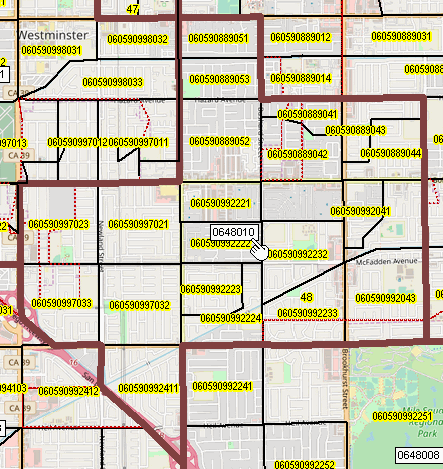
 .. click graphic for larger view. Congressional Communities Online. This document provides an overview of the Congressional Communities online/interactive webserver. This application has been developed by Warren Glimpse and Takashi Hamamoto and is presently in an illustrative, provisional structure. All that is required to use this application is a Web browser. iOS and Android versions are being developed. The Web mapserver used to develop this online version uses the same core structure as the Windows desktop CV XE GIS. Topics • MapServer Start-Up View • MapServer User Interface & Legend Panel • Creating National Scope CD Thematic Pattern View • Find/Search Tools -- finding your Congressional Community .. and obtaining a data profile for the selected geography. • Map Window Navigation Visual Orientation -- Start-up View .. goto top The "CACC" web-based mapserver start-up view is shown below; use the mapserver operation with most browsers. Access the mapserver real-time that shows this view interactively. The real-time view might differ due to changes not yet reflected in the following graphic. The start-up view is focused on California Congressional District 48. This view shows patterns of economic prosperity, median household income, by block group (BG). 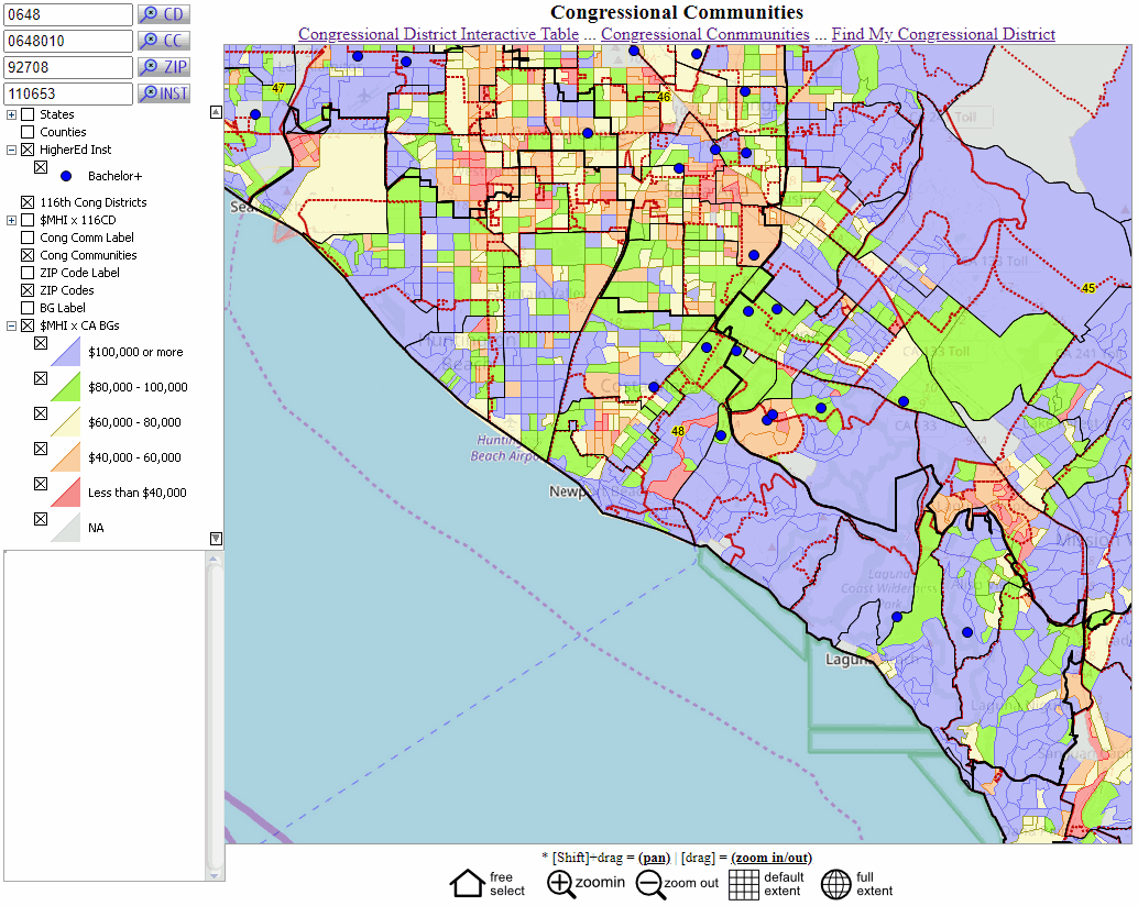 .. click graphic for larger view. Developing/Modifying the MapServer GIS Project .. goto top The Geographic Information System (GIS) project used in the mapserver is developed using the ProximityOne CV XE GIS Windows-based software (not required to use the mapserver). The GIS project used by the mapserver is provided in a ready to use form. No knowledge of the Windows-based software is required. Optionally use the CV XE GIS version to modify the GIS project with, for example, a different start-up view or to add other data/geography. 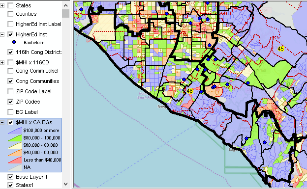 MapServer User Interface -- What am I seeing .. goto top The above mapserver graphic shows the legend panel, map window, profile panel (lower left) and some related tool buttons and links. This is the user interface to use the mapserver -- and is an interactive HTML page. The content of the HTML page may be modified in any manner, e.g., a variation to with a design more like a dashboard. Legend Panel As shown in the legend in the upper left, this view shows layers described below: - The legend panel is a scroll section; use right scroll bar to navigate vertically. - When a layer is checked it is shown in the map window. .. click the checkbox to show (x appears) or uncheck to remove the layer view from the map window. .. these are temporary/navigational operations to create the desired view. National scope layers: U.S. by State U.S. by County U.S. Higher Education Institutions (Institution ID label) U.S. Higher Education Institutions (blue markers) U.S. by 116th Congressional District (yellow labels show the CD number) U.S. by 116th Congressional District (thematic pattern of median household income) .. examining patterns of economic prosperity by sub-neighborhood State level files; set up for any state: California statewide Congressional Communities (CC Labels - 6-character codes) California statewide Congressional Communities (CC polygons - sets of contiguous BGs) California statewide ZIP Code areas (ZIPCode Labels) California statewide ZIP Code areas (ZCA polygons) California statewide Block Group (Block group geocode as label) California statewide Block Group (thematic pattern of median household income) .. examining patterns of economic prosperity by sub-neighborhood Base layer -- tiling topography -- global scope It is easy to view a CC in context of BGs and/or congressional districts. The thematic pattern can be optionally included in the view. Other layers can be added, in a manner similar to using CV XE GIS. Using the interactive version, explore checking the layers on/off. Creating National Scope CD Thematic Pattern View .. goto top To create a national scope congressional district thematic pattern view, showing patterns of median household income, proceed as follows. Start the mapserver -- even if in operation, restart. Step 1 -- Uncheck these layers: .. High Ed .. 116th CD .. Cong Comm .. ZIP Codes .. MHI by CA BGs .. Base Layer 1 (navigate to bottom of legend panel) Step 2 - click the Zoom to Default Extent button below map window. Step 3 - Click on this one layer: .. $MHI by 116th CD Click + button at left of checkbox in above layer name (this expands the legend showing the interval/section colors and ranges). Map window refreshes with this view: 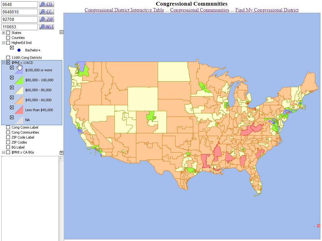 .. click graphic for larger view. .. optionally check on the 116th CD Labels in legend panel to shows state CD codes. Find/Search Tools -- finding your Congressional Community .. goto top Find/Search tools are located above the legend panel (top left). Use these tools to locate a geography of interest based on a code that you enter. Enter the code for the tool/geography of interest. Click the corresponding search button. A default value is shown for each type of geography. The map window refreshes showing a zoom in view to the selected geography. In each case, as the geography is located, the data profile for this geography is shown in the lower left Data Profile Panel. Find CD Key in the 4-character state FIPS code and CD code in that state. 4829 is the code for the Texas 29th CD. Find CC Key in the 6-character state FIPS+CD code+CC code (CCN). 0648001 is the code for the California, CD 48, CC 001. .. for this mapserver version, this must be a CC in California. Find ZIP Key in the 5-character ZIP code. Try your own ZIP code. .. this might be the first step in finding your Congressional Community. .. for this mapserver version, this must be a code in California. Find Inst Key in the 6-character institution code (IPEDS 2019). Examples: .. 228778 is the ID for the University of Texas Austin. .. 177117 is the ID for Cottey College, Nevada MO. Map Window Navigation Tools .. goto top Click on Map The following view illustrates use of the zoom in and CC profile. Click on a CC and a profile appears in lower left panel. The bolder outline black boundaries show congressional districts. The lighter outline black boundaries show CCs labeled with the 6-character CC code. The blue highlighted CC (4832004) has been clicked/selected; the demographic profile is shown in the lower left panel. The profile shows the field names in the CC layer and values for the selected CC. 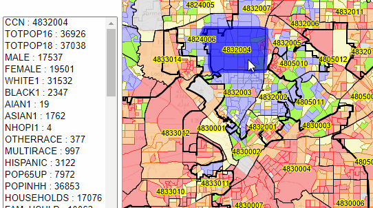 Zoom-in .. click this button then click in map window and drag down right; release to zoom in. Zoom-out .. click this button then click in map window and drag up left; release to zoom out. Pan/Drag .. click this button then click in map window, hold shift key down and drag in preferred direction; entire map window shifts. Default Extent .. click this button and map window view shifts to lower 48 states. Full Extent.. click this button and map window view shifts to global view. |
|
|