
|
|
|
Mapping Census Tract Demographics
.. using visual data analytics and developing business intelligence .. this section provides a 4-step procedure to develop thematic pattern and reference maps for census tracts. The focus of this section is on mapping Census 2010 census tracts using data from the 2014 American Community Survey (ACS2014). A similar set of steps could be followed for Census 2000 tracts with Census 2000 data or Census 2010 tracts with Census 2010 demographics or different vintage ACS data. Steps summarized here can be used with most any Windows-based computer having Internet access.
October 2018 Supplement Section
• see section on developing a map for a census tract of interest ... below. 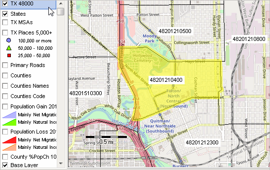 • how do customers and sales relate to market area characteristics? • is their a better configuration of locations or territory/service area structures? • how can you more effectively examine customer and sales patterns? • what and where are areas of missed opportunities? See related sections: • Using GIS & Data Analytics • Mapping Statistical Data Benefits of this section include providing help for those: • having a specific interest in mapping census tract demographics. • with little or no experience in using GIS. • getting started with CV XE GIS. These resources and instructions provide a real, not demo, valuable tool that anyone can use, without fee, to create county by census tract thematic pattern maps. Use any of the "richer" demographic-economic data (not just median household income) from the latest ACS 5-year data (see scope -- table shells xls). The steps described below can be performed with any version of CV XE GIS, including the no fee version. Start from scratch and develop thematic pattern maps like that shown below. Questions, need help? See the FAQs below. Call with questions - 888.364.7656. Or, use this form and put questions in the text section. While this application is focused on ACS 2014 median household income for Dallas County, TX census tracts, you can follow these steps for other areas and subject matter. In your own applications, choose any ACS subject matter for any county/area of interest. The following view shows the end result of steps described below. Choose your own county of state; choose your own subject matter; select your own colors and labeling; choose your own zoom view; and more. Patterns of Economic Prosperity; Dallas County, TX by Census Tract 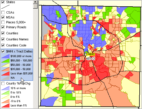
Alternatives to the data development steps presented in this section include: • use the pre-packaged, no cost, state by neighborhood/tract applications. ... choose a state, install the software/project, start making tract maps. ... these are older data and offer no subject matter options (they us only median household income). • use the fee-based all U.S. census tracts with integrated demographics datapak. ... provided with ready-to-use GIS project; use with any CVGIS version. Mapping Census Tracts Demographics Steps These steps should take an inexperienced user 10-15 minutes to develop a new CVGIS project view. Steps can be performed at separate times. 1. Install CV XE GIS 3. Get census tract shapefile 4. Get census tract subject matter data (median household income or other) 5. Create map view(s) 1. Install CV XE GIS • Run the CV XE GIS Installer -- http://proximityone.com/cv/1/cvxe_installer.exe. .. omit this step is CV XE GIS already installed. .. requires Internet and Windows computer. 2. Start CV XE GIS • At completion of installation, CV XE GIS automatically starts. • If CV XE GIS has been previously installed, start CV XE GIS using the desktop icon. • At start-up, the map display shows a view of the Dallas, TX metro. .. this assumes the start-up configuration file has not been modified. 3. Get the census tract shapefile See about using the API-Geographic Data in the User Guide for more information about these steps. Optionally skip this step. The Dallas County tracts geography (shapefile) are part of the installer, ready for next step. .. but if you want to see how to use any county by tract, follow these steps. • If not running, start CVGIS (use desktop icon). • From the main menu, start the APITools>Geographic Data • See the Geographic Data form in the above link view. • Set the selections for Dallas County Census 2010 census tracts • Download the the file using default settings. • Close this form after download. Do not add it to the open GIS project. 4. Get the census tract median household income data (or other subject matter) See about using the API-Statistical Data in the User Guide for more information about these steps. • If not running, start CVGIS (use desktop icon). • From the main menu, start the APITools>Statistical Data • See the APITools - Statistics form opens. • Selections default for ACS 2014 5-year data and census tracts .. see Dataset dropdown in left panel .. .nothing to change). • In the Geographic Areas section at left, click the "Load from File" button, click Open on the default file name. .. this step sets the geography for the data extraction; see details in above link for more about this operation. .. the Geographic Areas listbox populates with Dallas COunty census tract codes. • The set of subject matter items to be extracted are listed in the Subject Matter Items section. .. the subject matter selections are already loaded. .. the list of items includes item "B19013_001E" - median household income. .. see details in above link for more information about this operation. • Click the Run button to create/download the the file. .. the grid populates as data are extracted; wait for 500+ tracts to be processed. .. a final message lists the names of the files created and permanently stored on your computer. • Note the name of the shapefile created and close this form after download. • Note the shapefile dbf has also been created in CSV structure. .. the CSV file is ready to be used with any application that can read CSV structured files. • Close this form. 5. Create thematic pattern map view(s) In the previous step, the shapefile "c:\cvgis\1\tl_2010_48113_tract10_xxx.shp" has been populated with the selected subject matter. For users with database open feature, the content of that shapefile dbf (c:\cvgis\1\tl_2010_48113_tract10.shp) may be viewed as a grid/table using CVGIS the CVGIS Database>Open feature as described here. See about adding a layer in the User Guide for more information about these steps. In the next step, the new shapefile ("c:\cvgis\1\tl_2010_48113_tract10_xxx.shp") is added to the existing project. The exact name of the file (value for "xxx" in above name) is the time-stamped value for when the file was created. This distinguishes this file from similarly named files that might have different subject matter. • If not running, start CVGIS (use desktop icon). • Using the Toolbar, under the main menu, click the AddLayer button (second from left with +). • See the Merge Files (dBMerge) form in the above link view. • In the opendialog, select the shapefile "c:\cvgis\1\tl_2010_48113_tract10_xxx.shp" (omit "). .. that shapefile is being added as a layer, .. it immediately shows with a gray fill pattern at the top of the legend panel to the right of the map window. Creating Thematic Pattern Maps See about using the layer editor in the User Guide for more information about these steps. There are now several ways to view median household income ($MHI) by tract. Here is one .. where the fill pattern of each tract is set to a solid color based on the value of $MHI. See details about these steps. • Dbl-click the tracts layer name at the top of the legend panel. .. this starts the Layer Editor; the Layer Editor is used to set attributes of any layer in the project. .. when modifications are made to a layer's attributes, these can be saved by saving the project with a new name. .. *note* -- a project cannot be saved using the no fee CVGIS viewer; all other CVGIS versions can save a project. .. you can proceed to make and use the final thematic pattern map with any version. Frequently Asked Questions Q. How do I perform a similar application using median family income for the Hispanic population? A. In step 3, before you click Run, key in the item code B19113I_001E as a new item as shown here: 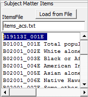 See this item in the full set of items description (xls file, line 18465) .. be sure to change the syntax for the item name from B19113I001 to B19113I_001E as shown above. .. select any item or any set of items in a similar manner. Developing a map for a census tract of interest ... the best way to view census tract boundaries in context of streets, other geography and earth surface features. ... these steps provide a no cost way to view the maps. If the CV XE GIS is not on your computer .. run the CV XE GIS Installer -- http://proximityone.com/cv/1/cvxe_installer.exe. .. omit this step is CV XE GIS already installed. .. requires Internet and Windows computer. Using CV XE GIS to view a census tract Consider census tract 48201210400. This tract is a low and moderate income tract determined from the table at http://proximityone.com/tractslmi.htm#table. To view this tract in the table ... - click ShowAll button below table - click .. table refreshes showing low & mod tracts in the Houston metro - scroll down the table rows until line 51 which is the first tract listed in Harris County Where is this tract in a map view? - start CV XE GIS and File>Open>Dialog and open the project c:\cvxe\1\us1.gis; the U.S. map by county appears. - there is no tract layer in this project/view; get Texas tracts shapefile using the CV File>GeoGateway feature. - start the CV File>GeoGateway feature; in section 1, scroll to the item Harris County and dbl-click that line. - from Section 2, reference view, choose 2017S; next dbl-click the line/row named TRACTS - Census Tracts, state. - next, click the Download button. - next click the Continue button. - waiting, click the Download successful button. - next, at Done. ... click the OK button. - click the Add Layer to Project button; then click OK and close the GeoGateway form. The map view now shows Texas census tracts - click the TX 48201 layer name at the top of the legend panel at left of map. - next click the binoculars icon on the second toolbar above the map. - with the Find Shapes form open, choose the field GEOID; paste the 11 character tract code in Value edit box. - check on Flash selected objects and Zoom to first .. checkboxes. - click the Find button; the tract is located and zoomed to. Close the Find shape form. The tract of interest is shown in the map window. Let's improve the view. - in the legend panel, uncheck the Population Gain .. and Population Loss .. layers. - click the zoom out button once. - check the Base Layer on. - the map window now shows tract 48201210400 in context of area streets and ground cover. This GIS project cannot be saved (for recall) using the no-fee version of CV XE GIS. Saving a GIS project requires CV XE GIS Level 1 or higher. ProximityOne User Group Join the ProximityOne User Group to keep up-to-date with new developments relating to metros and component geography decision-making information resources. Receive updates and access to tools and resources available only to members. Use this form to join the User Group. Support Using these Resources Learn more about accessing and using demographic-economic data and related analytical tools. Join us in a Data Analytics Lab session. There is no fee for these one-hour Web sessions. Each informal session is focused on a specific topic. The open structure also provides for Q&A and discussion of application issues of interest to participants. Additional Information ProximityOne develops geodemographic-economic data and analytical tools and helps organizations knit together and use diverse data in a decision-making and analytical framework. We develop custom demographic/economic estimates and projections, develop geographic and geocoded address files, and assist with impact and geospatial analyses. Wide-ranging organizations use our tools (software, data, methodologies) to analyze their own data integrated with other data. Follow ProximityOne on Twitter at www.twitter.com/proximityone. Contact us (888-364-7656) with questions about data covered in this section or to discuss custom estimates, projections or analyses for your areas of interest. |
|
|