
|
|
|
September 2019 .. a Combined Statistical Area (CSA) is a group of two or more adjacent metropolitan areas; they include contiguous metro counties that have demographic-economic affinity. These 172 areas (September 2018 vintage) are important in wide-ranging geographic and demographic analysis. Based on the 2018 population estimate, these areas include 256.2 million population of the total U.S. population of 327.2 million (78.3 percent). CSAs are at least two adjacent metropolitan areas -- reflecting a larger and broader market/service/impact assessment area. Due to their size (of many), it is often possible to develop more detailed custom demographic-economic estimates and projections than at the county or metropolitan area level. See more below about CSA definitions and relation to other geography. Use ProximityOne CSA demographic projections to 2060 to examine how CSA population is changing. Annual estimates and projections are developed at the county and metro levels enabling analysis of trends and patterns at the CSA and component CSA geography. Contact us for details. This section provides an overview of recent demographic trends among CSAs and provides access to tools to further examine these areas, markets, and demographic-economic-business related characteristics. Use the interactive table below to examine patterns and relationships among CSAs of interest. Use the GIS project and datasets described below to examine CSAs in a mapping and geospatial analysis context. Patterns of 2018 Population by 2018 CSA The following graphic shows the September 2018 vintage CSAs based on the 2018 official population estimates. The intervals/colors are depicted in legend panel at left of map window. Create custom maps similar to this view for your regions of interest. Use the GIS project/datasets to examine alternative patterns such as percent change for different time periods. Set queries to include CSAs by peer group. Click graphic for larger view with more detail; expand browser window for best quality view. Larger view shows CSAs labeled with percent population chnage 2010-2018. 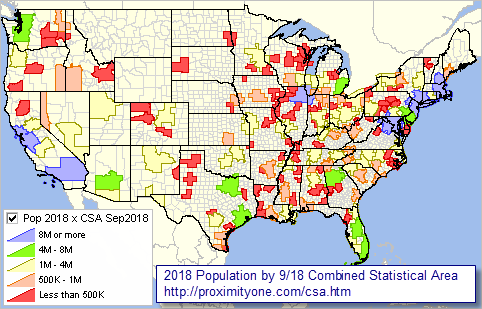 View developed with CV XE GIS software using the us1.gis GIS project. Analyze CSA-Metro-County Demographic Patterns using GIS on Your Computer View maps for your areas of interest. Add other geography/subject matter. Modify content, color settings, labeling and other attributes. Contact us for details. Population by Combined Statistical Area: 2010-2018 Interactive Table Click ShowAll button between Find/Queries. Click column header cell to sort table on that column; click again to sort other direction. Use mouseover on column header to view column description. See usage notes below table. See demographic-economic interactive tables. Usage Notes Operations: • Click ShowAll between queries/filters. • Click a column header to sort on that column; click again to sort other direction. • Find-in-Name button .. enter a partial case-sensitive area name in the edit box to right of Find-in-Name button. .. click to Find-in-Name button to show only rows with that text in the area name (column 1). • FindCSA button .. enter an exact 3-character CSA code in the edit box to right of FindCSA button. .. click to FindCSA button to show only rows with that text in the CSA code (column 4). .. the default code 288 is the Houston CBSA code. • Population 2018 Min & Max> button .. click to show only peer group areas based on population .. the ShowAll button must be clicked before using this feature. .. in min and max edit boxes ... ... enter the minimum 2018 population in the left edit box. ... enter the maximum 2018 population in the right edit box. .. click 2018 Pop Min & Max button to view CSAs in group. • Click ShowAll between queries/filters. Items in Table - Name - St - CSA - Population 2010 - Population 2011 - Population 2012 - Population 2013 - Population 2014 - Population 2015 - Population 2016 - Population 2017 - Population 2018 - Pop Chg 2010-18 - %Pop Chg 2010-18 - Rank Pop 2018 - Rank %PopChg 2010-18 About CSAs Combined Statistical Areas (CSAs) consist of two or more adjacent Core-Based Statistical Areas (CBSAs) that have an employment interchange measure of 15 or more. CSAs and CBSAs are geographic delineations defined by OMB based on demographic-economic data developed by the Census Bureau. See related terms below. CSAs are not all huge populated areas; they range from less than 40,000 population to more than 23 million population. Some metros than might seem to be included as CSAs are not. The Phoenix, AZ metro would be the 13th largest CSA based on population size but is not a CSA as it has not adjacent MSA or MISA. Codes for Metropolitan Statistical Areas, Micropolitan Statistical Areas, and Related Statistical Areas. Codes for metropolitan and micropolitan statistical areas (collectively referred to as "Core Based Statistical Areas" or "CBSAs"), metropolitan divisions, Metropolitan divisions are distinguished by a 5-digit code ending in "4." Combined Statistical Area Consists of two or more adjacent core based statistical areas (CBSAs) that have an employment interchange measure of 15 or more. Core Based Statistical Areas (CBSAs) Refer collectively to metropolitan statistical areas and micropolitan statistical areas. CBSAs consist of the county or counties (or equivalent entities) associated with at least one core (urbanized area or urban cluster) of at least 10,000 population, plus adjacent counties having a high degree of social and economic integration with the core as measured through commuting ties. Employment Interchange Measure (EIM) Is a measure of ties between two adjacent entities. It is the sum of the percentage of workers living in the smaller entity who work in the larger entity and the percentage of employment in the smaller entity that is accounted for by workers who reside in the larger entity. Metropolitan Division A county or group of counties (or equivalent entities) delineated within a larger metropolitan statistical area, provided that the larger metropolitan statistical area contains a single core with a population of at least 2.5 million and other criteria are met. A Metropolitan Division consists of one or more main/secondary counties that represent an employment center or centers, plus adjacent counties associated with the main/secondary county or counties through commuting ties. Not all metropolitan statistical areas will contain metropolitan divisions. Metropolitan Statistical Area A geographic entity delineated by the Office of Management and Budget for use by federal statistical agencies. Metropolitan statistical areas consist of the county or counties (or equivalent entities) associated with at least one urbanized area of at least 50,000 population, plus adjacent counties having a high degree of social and economic integration with the core as measured through commuting ties. Metropolitan and micropolitan statistical areas are collectively referred to as "Core Based Statistical Areas" (CBSAs). Micropolitan Statistical Area A geographic entity delineated by the Office of Management and Budget for use by federal statistical agencies. Micropolitan statistical areas consist of the county or counties (or equivalent entities) associated with at least one urban cluster of at least 10,000 but less than 50,000 population, plus adjacent counties having a high degree of social and economic integration with the core as measured through commuting ties. Metropolitan and micropolitan statistical areas are collectively referred to as "Core Based Statistical Areas" (CBSAs). Principal City The largest incorporated place with a population of at least 10,000 in a core based statistical area (CBSA), or if no incorporated place of least 10,000 population is present in the CBSA, the largest incorporated place or census designated place (CDP) in the CBSA. Additional places that meet specific criteria are also identified as principal cities. Support Using these Resources Learn more about demographic economic data and related analytical tools. Join us in the Data Analytics Lab sessions. There is no fee for these Web sessions. Each informal session is focused on a specific topic. The open structure also provides for Q&A and discussion of application issues of interest to participants. ProximityOne User Group Join the ProximityOne User Group to keep up-to-date with new developments relating to geographic-demographic-economic decision-making information resources. Receive updates and access to tools and resources available only to members. Use this form to join the User Group. Additional Information ProximityOne develops geographic-demographic-economic data and analytical tools and helps organizations knit together and use diverse data in a decision-making and analytical framework. We develop custom demographic/economic estimates and projections, develop geographic and geocoded address files, and assist with impact and geospatial analyses. Wide-ranging organizations use our software, data and methodologies to analyze their own data integrated with other data. Follow ProximityOne on Twitter at www.twitter.com/proximityone. Contact ProximityOne (888-364-7656) with questions about data covered in this section or to discuss custom estimates, projections or analyses for your areas of interest. |
|
|