
|
|
|
.. the Situation & Outlook Desktop integrated software & database .. helping you to create stories, examine patterns & trends, and create insights Use the latest model-based U.S. by county demographic time series to develop demographic profiles and analyze demographic-economic patterns and change. See these examples of profiles for Los Angeles County: HTML and XLS. Create cross-county spreadsheets for geo-comparative analysis. See XLS example of Miami metro counties showing the time series for the selected item Hispanic males. View demographic attributes for ~330 all items in the database. Population by components of change: birth, deaths, migration by type. Group quarters population. Population by age crossed by race/origin crossed by gender. The "tip of the iceberg" -- read on below. Save display results as XLS or HTML. These data, insights, capabilities are available to members of the ProximityOne User Group at no fee. Install the package on your Windows computer and get started immediately. Create stories. Gain insights in to patterns. Document and better understand your market. See FAQ section below. To start, run the Outlook2060 installer. Requires your User Group userID. No fee. Register here. This remainder of this document provides provisional getting started information for the Situation & Outlook Desktop integrated software & database also referred to as Outlook2060. The Outlook2060 installer places the ready-to-use Outlook2060 software and Outlook2060 database on this Windows computer. Start Outlook2060 using the desktop icon or from Windows Explorer by clicking c:\outlook2060\outlook2060.exe. The no fee version of Outlook2060 is available exclusively to member of the ProximityOne User Group and Level 1 users. The User Group version of the Situation & Outlook Desktop software provides access to a limited scope national scale U.S. by county demographic database. This database is a subset of the full Situation & Outlook database. The database includes approximately 330 subject matter items for each county, annually for the period 2010-18. More information is provided about these data at http://proximityone.com/countytrends.htm. Optionally, use the interactive provided on that page as a companion data access tool. Data provided in the Outlook2060 database provide an extended set of data include annual population by age, gender and race/origin. These data have been developed by the Census Bureau and are model based estimates used as control totals for development of more detailed 2018 American Community Survey (ACS) to be released fall 2019. Data in the database included with the installer were released by the Census Bureau in June 2019. ProximityOne uses these data to develop annual projections to 2060. Collectively these estimates and projections comprise the ProximityOne Situation & Outlook database. The Census Bureau does not provide subnational demographic projections. While the data for the period 2019 through 2060 are not provided by the installer, they are available as optional add-ons. Terms of Use. Software and data installed by the installer are proprietary to ProximityOne. The software and data may be used only for personal, non-business applications. The data are authorized for use with ProximityOne software only. Business users may acquire a separate license authorized for commercial applications. These is no warranty or guarantee regarding any aspect of these software and/or data or their use. The user is solely responsible for any use of the software, data or their joint/individual use. Journalists, news organizations and government agencies may use HTML pages generated using the system for published news and Web sites. Getting Started The start-up screen appears as shown below. 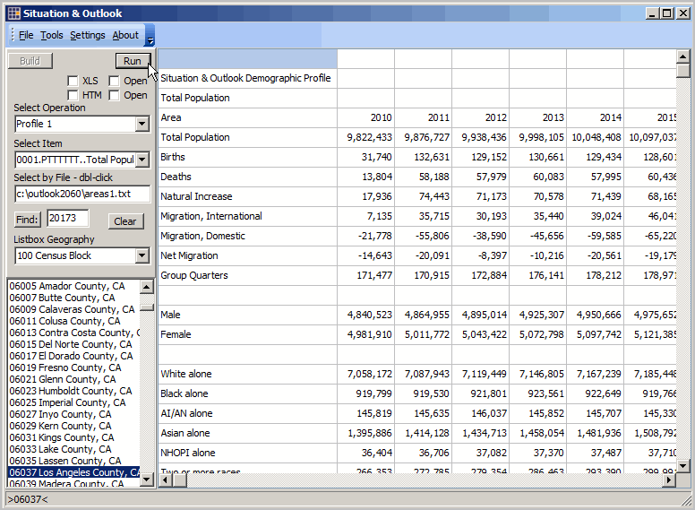 The main components of the screen/GUI are the grid (majority of the screen), control panel at left of the grid, and menu at the top of the form. In this start-up view, the user dbl-clicks the county code/name of interest in the listbox shown in the control panel. The "Profile 1" data are displayed in the grid. In this example, data are shown for Los Angeles County (geocode or state-county code 06037). Select any county and dbl-click that name in the listbox to view the Profile 1 for that county. The Profile 1 shows data for the selected county annually 2010 through 2018 with change and percent change columns at the far right. Subject matter items correspond to rows: population and components of change, gender, race/origin, and 5-year age cohort. This is a unique data structure, designed for maximum consumability and insights in the area composition and trends. While the Census Bureau developed the content, the Census sourced data have extensively modified for this form of analytical access. Using the Run Button. While data for an area may be displayed by dbl-clicking the name of an area, the Run button may be used to run/display a set of multiple counties (including all counties selected in the listbox). Use the Clear button to clear all selections in the listbox. Then click on names of a few counties you want included. When Run is clicked all areas are processed. The grid is overwritten as each area is displayed. Optionally create and use an "areas selections file." The areas1.txt file included by the installer provides an example of constructing the file. dbl-click the Areas file name (in the Areas edit box). Those areas are selected. Now click the Run button to process these areas. Aggregating Data to Metro or Region Level. When multiple areas are selected, a group summary is computed and displayed at end of processing. This feature is not active in this version. Saving Output as XLS and HTML. The results of data displayed in the grid may be saved to XLS and HTML formats. Click the output options on (below Run button) before clicking Run (or dbl-clicking listbox name). Examples are included in the c:\outlook2060\1 for Los Angeles County. Your saved XLS/HTML files are saved there also. Subject Matter Items in the Database. Available subject matter items are listed in the in the combobox "Select Item" in the control panel. For each item there is a sequence number, field name and short name. Other Operations Available. The "Profile 1" display option, reviewed above, is the default display as shown in the "Select operation" combobox in the control panel. Other options available this version are: • Single items - selected areas .. displays a selected item (e.g., total population) for selected areas .. dbl-click the desired item in the Select item combobox to select item • All items -selected areas (typically one area) .. displays one line for each ~330 subject matter items FAQ .. goto top Q. What is the scope of time series included in the database? A. The annual database is structured to cover the period 2010 through 2060. Q. What is the scope of time series included in the database of the User Group version? A. Annual data, 2010 through 2018. During 2019, some series wil be extended to 2019. .. these data are the "historical core" data used to develop current estimates and projections. Q. What is the scope of geography included in the database of the User Group version? A. U.S. by county. Q. What is the scope of subject matter included in the database of the User Group version? A. 1) Population and components of change. 2) Population by age (5-year age cohorts), crossed by race/origin, crossed by gender. 3) progressively expands over time. Q. When is the software and database updated? A. Features of the software are continuously being improved and expanded. Subject matter data are continuously being added and updated. Support Using these Resources Learn more about accessing and using demographic-economic data and related analytical tools. Join us in a Data Analytics Lab session. There is no fee for these one-hour Web sessions. Each informal session is focused on a specific topic. The open structure also provides for Q&A and discussion of application issues of interest to participants. Additional Information ProximityOne develops geodemographic-economic data and analytical tools and helps organizations knit together and use diverse data in a decision-making and analytical framework. We develop custom demographic/economic estimates and projections, develop geographic and geocoded address files, and assist with impact and geospatial analyses. Wide-ranging organizations use our tools (software, data, methodologies) to analyze their own data integrated with other data. Follow ProximityOne on Twitter at www.twitter.com/proximityone. Contact us (888-364-7656) with questions about data covered in this section or to discuss custom estimates, projections or analyses for your areas of interest. Contact ProximityOne (888-364-7656) with questions about data covered in this section or to discuss custom estimates, projections or analyses for your areas of interest. |
|
|