
|
|
|
-- U.S. by County Characteristics and Trends; Age Groups 65+, 75+ and 85+ April 2020 .. Americans are living longer .. by 2060, life expectancy for the total population is projected to increase by about six years, from 79.7 now to 85.6 in 2060. The U.S. projected total population for 2020 is 332,639,000 of which the population ages 65 and over is 56,052,000 (16.9%). In 2060, the total population (scenario 1) will be 404,483,000 of which the population ages 65 and over will be 94,676,000 (23.4%). More about projections. This section is focused on three age groups; population 65, 75 and 85 years and over. Use tools and data to analyze characteristics and trends these age groups annually from 2010 through 2018 by county. New, updated, extended data will be added to this section in June 2020. Examining patterns and characteristics of these age groups for the Asian population, Hispanic population .. other population groups .. or drill-down into their socioeconomic characteristics ... or drill-down for sub-county geography .. read more below. We want to hear from you. Please send us an email to let us know of questions and how to improve these resources. U.S. Population Age Group Estimates, 2018 (latest official estimate)
Analytical Resources Use the interactive table below to view, query, rank and analyze patterns of theses age groups. Examine counties in a selected state, metro or peer group. Develop maps and geospatially analyze these data using GIS resources. Integrate these with other data and geography to obtain a more comprehensive picture of the local/regional economy -- and visually compare regions. Combine these data with your data to assess needs, resource allocation and patterns of interest. Maps Tell a Story, or a Few The following three maps show patterns of these three age groups: 65+, 75+, 85+. The maps show the percent of the respective age group population as a percent of total population in 2018. Virginia and Appalachia counties appear to have a relatively high 65+ percent that dissapates for that area and most of the southeast when compared to the 85+ group; the Atlanta metro area never has a relatively high percent older population. The region starting with Kansas and moving north has a consistently relatively higher percent senior population which becomes more pronounced for the 85+ population. Many of these counties are sparsely populated, have limited employment and business opportunities, fewer families with children and related factors that result in relatively smaller younger age populations. Patterns of the Population Ages 65 Years and Over by County 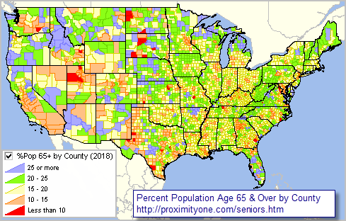 -- view created using the ProximityOne CV XE GIS and associated GIS Project Patterns of the Population Ages 75 Years and Over by County 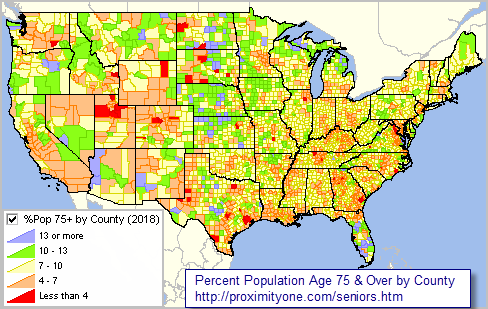 -- view created using the ProximityOne CV XE GIS and associated GIS Project Patterns of the Population Ages 85 Years and Over by County 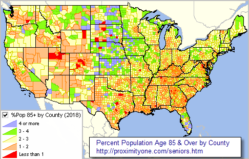 -- view created using the ProximityOne CV XE GIS and associated GIS Project Senior Population by Age Group by County and CBSA/Metro -- Interactive Table Click ShowAll button between Find/Queries. See usage notes below table. See related interactive tables. Usage Notes • The CBSA/Metro code used in the table is based on the current Sep 2018 CBSA vintage. • Click ShowAll button between specific queries. • Click a column header to sort on that column; click again to sort other direction. • Click ShowAll button between specific queries. • Enter min and max population values in edit boxes; click Pop18 button; table refreshes. Making Your Maps .. Installing & Using the GIS Project .. goto top The population age group data have been added to the default GIS project included with the CV XE GIS installer and installer update. See about using the age group layers below. 1. Install the ProximityOne CV XE GIS on any Windows computer ... run the CV XE GIS installer ... requires your userid .. no cost .. signup here ... take all defaults during installation 2. The GIS project automatically opens with the following view:  ... the start up legend (to left of map window) shows these layer settings:  ... to view the age group map views change the legend panel settings as shown below:  ... uncheck (turn off) the checkbox by the "Population Gain ..." and "Population Loss ..." layers showing in legend. ... check (turn on) the checkbox by the "Population 65 Years" layer showing in legend at left of map window. ... the view now appears similar to the U.S. by county population 65 years and over map shown above. ... repeat these settings changges to view other age groups. ... see the CV XE GIS User Guide for more information about CV XE GIS operations. ... join us in a Data Analytics Web Session for demonstration and to discuss applications. Terms of Use .. goto top The CV XE GIS project is available for use by members of the ProximityOne User Group and licensed users of the CV XE GIS software. There is no warranty of any type associated with any aspect of the use of the CV XE GIS software, related GIS project and files, nor information provided via this or related ProximityOne resources. The user is solely responsible for any use made of any of these resources. Software and data resources may not be redistributed. Scope and Use of the Age Group Data goto top Items included in the table - AreaName - St - StCty - CBSA - Population 2010 - Population 2018 - Population %Change 2010-18 - Age65+ 2010 - Age65+ 2018 - Age65+ %Total - Age65+ %Change 2010-18 - Age75+ 2010 - Age75+ 2018 - Age75+ %Total - Age75+ %Change 2010-18 - Age85+ 2010 - Age85+ 2018 - Age85+ %Total - Age85+ %Change 2010-18 Related Data .. goto top • County Projections to 2060 • Situation & Outlook data base and information system • County Population & Components of Chnage time series Extending the Scope of Senior Characteristics & Patterns .. goto top This section is focused on three age groups and their relation to the total population from 2010 through 2018. There are several data resources that can be used to expand the scope of subject matter, geography and time frame that we will review in this section in weeks ahead. Notably, the American Community Survey Public Use Microdata Samples (microdata -- ACS 2018 PUMS) can be used to develop custom subject matter estimates Public Use Microdata Areas (PUMAs). PUMAs include 2,768 areas, sets of contiguous census tracts, covering the U.S. wall-to-wall. ProximityOne User Group .. goto top Join the ProximityOne User Group to keep up-to-date with new developments relating to metros and component geography decision-making information resources. Receive updates and access to tools and resources available only to members. Use this form to join the User Group. Support Using these Resources Learn more about accessing and using demographic-economic data and related analytical tools. Join us in a Data Analytics Lab session. There is no fee for these one-hour Web sessions. Each informal session is focused on a specific topic. The open structure also provides for Q&A and discussion of application issues of interest to participants. Additional Information We are continuously watching and analyzing the economy .. from the national to sub-county levels. And sharing this information with you. This section is about one part of of it. We develop, organize and and integrate the pieces for a more holistic look and assess how change might affect us in the months and years ahead. ProximityOne develops geodemographic-economic data and analytical tools and helps organizations knit together and use diverse data in a decision-making and analytical framework. We develop custom demographic/economic estimates and projections, develop geographic and geocoded address files, and assist with impact and geospatial analyses. Wide-ranging organizations use our tools (software, data, methodologies) to analyze their own data integrated with other data. Follow ProximityOne on Twitter at www.twitter.com/proximityone. Contact us (888-364-7656) with questions about data covered in this section or to discuss custom estimates, projections or analyses for your areas of interest. |
|
|