
|
|
|
April 2020 ... updated world population estimates and projections by country show that the world population is projected to grow from 6.9 billion in 2010 to 9.4 billion by 2050, an increase of 2.5 billion (36.5%). This section provides tools to view, compare, analyze these projections, develop alternative scenario projections, and examine underlying data used to develop the projections. Assess the implications of changing geopolitical, demographic and economic factors and how they might impact future change for areas and matters of interest. See more about these data and alternative scenario projections and impact assessment. Largest 10 Countries in 2050 based on Total Population (millions)
Patterns of Population Change by Country: 2010-2050 -- Europe The following graphic shows percent change 2010-2050 by country and country code. Click graphic for larger view. Larger view shows legend with intervals/color assignment and population percent change 2010-2050 and country name as labels. Expand browser window to full screen for best quality view. 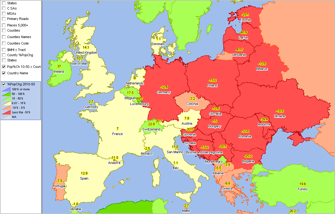 - view developed using ProximityOne CVGIS software and associated project. - use these resources to develop similar views for any area. Modify subjects, zoom, colors, labels, add your data. Patterns of Population Change by Country: 2010-2050 -- Africa The following graphic shows percent change 2010-2050 by country and country code. Click graphic for larger view. Larger view shows legend with intervals/color assignment and population percent change 2010-2050 and country name as labels. Expand browser window to full screen for best quality view. 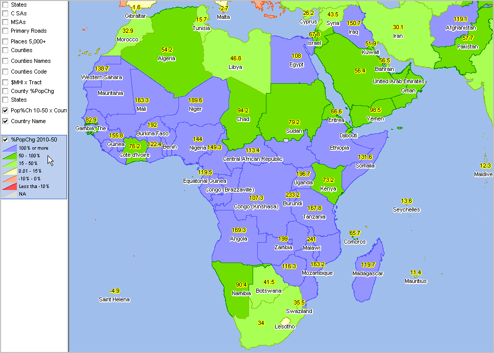 - View developed using CV XE GIS software and associated project. - use these resources to develop similar views for any area. Modify subjects, zoom, colors, labels, add your data. ... World by Country Use the interactive ranking table to examine how individual countries are changing. Click on a column header to sort; click again to sort in the other direction. See interactive tables to view other geography and subject matter. World Population by Country; 2010 - 2050 -- interactive table World by Country Population Projections World by country population projections shown in the above table are a part of the database updated annually by the Census Bureau International Programs Center. The scope of these data include midyear population, area and density; population by age and gender; birth and death, migration and growth rates; births, deaths and migrants; life expectancy and mortality rate; and fertility. ProximityOne has integrated these data with other data to develop alternative scenario projections based additional subject matter including political, economic and other data using different methodologies. The alternative scenario projections utilize the ProximityOne CV XE GIS modeling tools and database. See ChartGraphics Population Pyramids that show combined population pyramid charts and associated table and worksheet. Compare alternative scenario age-gender-race/origin estimates and projections by country. See examples of using these integrated charts and tables to examine the future of Indonesia. Develop this type of analysis for any country. Using CV XE GIS GIS tools, additional subject matter, sub-national geography and user's own data can be added for mapping and geospatial analysis. Assess the implications of changing geopolitical, demographic and economic factors and how they might impact issues of interest. Contact us for more information (key in 'world outlook' in text section). Support Using these Resources Learn more about accessing and using demographic-economic data and related analytical tools. Join us in a Data Analytics Lab session. There is no fee for these one-hour Web sessions. Each informal session is focused on a specific topic. The open structure also provides for Q&A and discussion of application issues of interest to participants. Additional Information ProximityOne develops geodemographic-economic data and analytical tools and helps organizations knit together and use diverse data in a decision-making and analytical framework. We develop custom demographic/economic estimates and projections, develop geographic and geocoded address files, and assist with impact and geospatial analyses. Wide-ranging organizations use our tools (software, data, methodologies) to analyze their own data integrated with other data. Follow ProximityOne on Twitter at www.twitter.com/proximityone. Contact us (888-364-7656) with questions about data covered in this section or to discuss custom estimates, projections or analyses for your areas of interest. |
|
|