
|
|
|
Community resilience is the sustained ability of a community to utilize its available resources to respond to, withstand, and recover from adverse situations.While often discussed in the context of natural disasters, the concept has evolved to include how a community handles long-term stresses like economic downturns, social disruptions, or climate change. A truly resilient community doesn't just "bounce back" to its original state; it often "bounces forward" by adapting and growing stronger from the experience. This section is focused on tools and data to help you bounce forward. • Interactive County Resilience Table • Interactive Map Patterns of 2024 County Resilience .. rate of individuals by county with three plus components of social vulnerability .. based on Census Bureau CRE data released January 29, 2026 .. click graphic for larger view 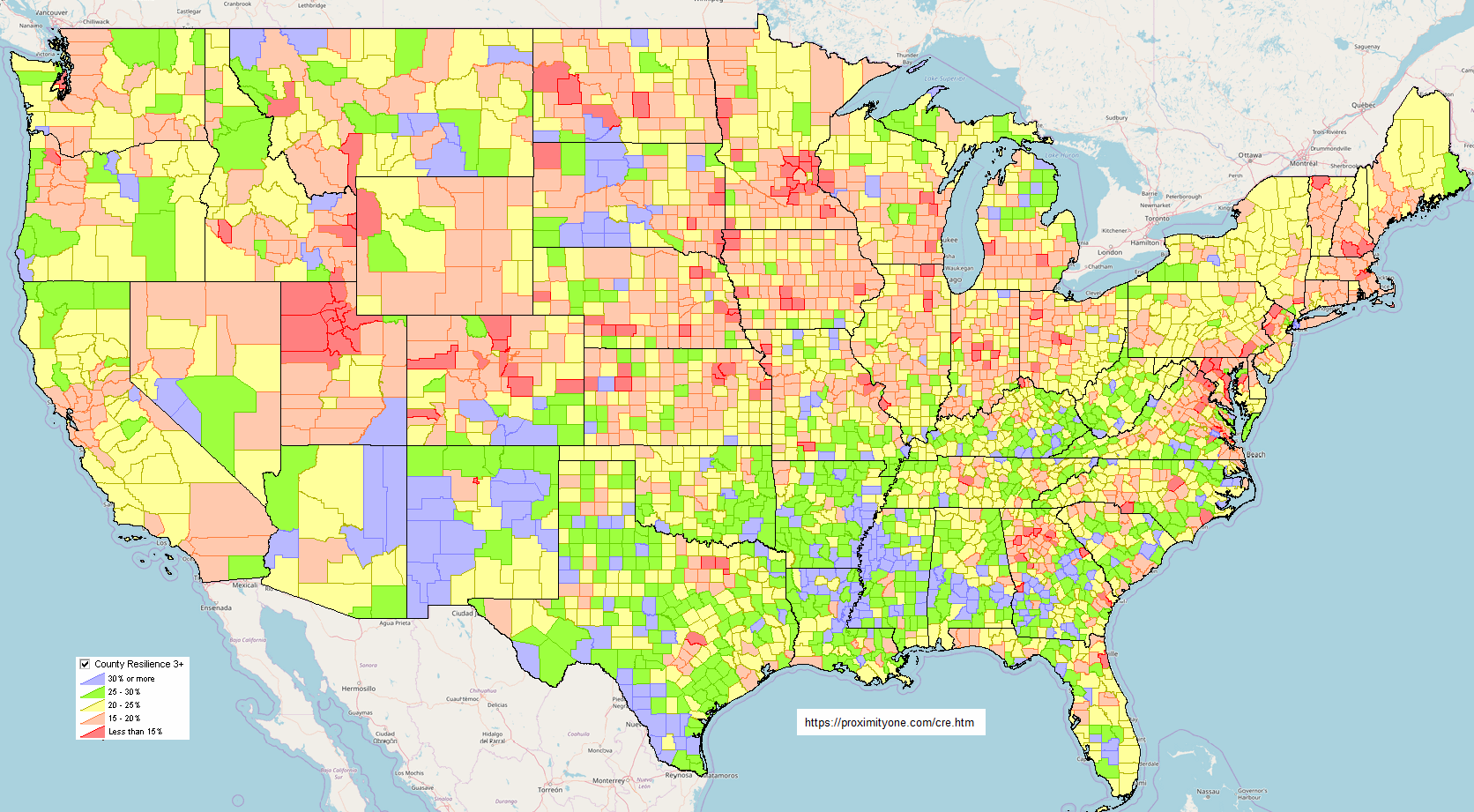 .. map prepared using VDA.GIS project and VDAGIS tools Core Elements of Resilience Research consistently points to several key pillars that make a community strong:
Social Capital: The strength of local networks, relationships, and trust among neighbors.
Socially connected people are more empowered to help one another during a crisis.
Economic Diversity: A robust and varied local economy that can withstand market fluctuations or the loss of a major employer. Infrastructure & Environment: The reliability of "lifeline" systems (water, power, transportation) and the health of the local ecosystem (clean air, water, and natural barriers like wetlands). Local Knowledge & Leadership: Having clear governance, effective communication channels, and leaders who can mobilize residents quickly. Public Health: Access to physical and mental healthcare services that can handle both day-to-day needs and sudden surges in demand. Why It Matters Resilience shifts the focus from reactive disaster response to proactive community building. By improving everyday health, social equity, and infrastructure, a community naturally reduces its vulnerability to future shocks. Measuring Community Resilience Geography:
U.S. by county
U.S. by tract 120th Congressional Districts 120th Congressional Communities County Resilience 2024 Interactive Table .. goto top Use the buttons & tools below the table for most effective use of this table and data. Click ShowAll button between Find/Queries. Use mouseover on column header to view column description. See usage notes below table. Usage Notes .. Click header cell to sort; click again to sort in other direction. .. Use buttons below table to query or place filters on the table. Column notes: County Name St GeoID -- FIPS StCty Vintage 2025 Estimates: Population 2020 Population 2025 Population Change 2020-25 Population PctChg 2020-25 Resilience: POPUNI -- Total population, excludes residents in adult correctional/juvenile facilities and college dormitories. 0_E -- Estimated number of individuals with zero components of social vulnerability 0_M -- Estimated margin of error for individuals with zero components of social vulnerability 0_PE -- Rate of individuals with zero components of social vulnerability 0_PM -- Rate margin of error for individuals with zero components of social vulnerability 12_E Estimated number of individuals with one-two components of social vulnerability 12_M -- Estimated margin of error for individuals with one-two components of social vulnerability 12_PE -- Rate of individuals with one-two components of social vulnerability 12_PM -- Rate margin of error for individuals with one-two components of social vulnerability 3_E -- Estimated number of individuals with three plus components of social vulnerability 3_M -- Estimated margin of error for individuals with three plus components of social vulnerability 3_PE -- Rate of individuals with three plus components of social vulnerability 3_PM -- Rate margin of error for individuals with three plus components of social vulnerability Using iVDA & Community Resilience .. goto top .. login within 10 minutes .. no cost. .. iVDA part of Visual Data Analytics .. about VDAGIS below .. iVDA works on any device; iPhone (not recommended due to screen size) .. iVDA is an iframe version of VDA Web GIS4 ..open related VDA Web GIS4 The default item mapped in layer "Tracts Resilience 3+" is "Rate of individuals with three plus components of social vulnerability" in the interactive table. iVDA is presented below in an interactive mapping window ... Regional Looks at Metros Containing Fastest Growth (2020-2025) Counties .. see iVDA display above for thematic map color patterns .. why these counties/metros? these counties have the highest population percent change from 2020 to 2025. Kaufman County, TX in Dallas MSA .. see pointer 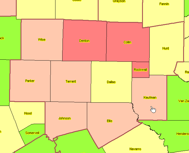 Jasper County, SC in Hilton Head MSA .. see pointer 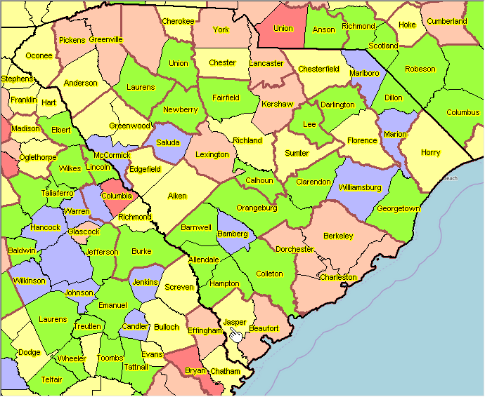 .. maps prepared using VDA.GIS project and VDAGIS tools About VDAGIS .. goto top The Visual Data Analytics (VDA) Geographic Information System (GIS) is a suite of tools and data that you can use to examine multi-sourced geographic, demographic and economic data. VDAGIS resources are developed and maintained by Warren Glimpse, ProximityOne (Alexandria, VA) and Takashi Hamilton, Tsukasa Consulting (Osaka, Japan). See more about VDAGIS. Add your own data. Web Sessions Join us in the weekly web sessions where we review wide-ranging topics on • current and trending geographic-demographic-economic characteristics • tools to access & use demographic-economic data with other data • using decision-making information & developing insights Additional Information ProximityOne develops geodemographic-economic data and analytical tools and helps organizations knit together and use diverse data in a decision-making and analytical framework. We develop custom demographic/economic estimates and projections, develop geographic and geocoded address files, and assist with impact and geospatial analyses. Wide-ranging organizations use our tools (software, data, methodologies) to analyze their own data integrated with other data. Contact us (888-364-7656) with questions about data covered in this section or to discuss custom estimates, projections or analyses for your areas of interest. |
|
|