
|
|
|
-- grade relevant children & their living characteristics September 2023 .. did you know? even pre-pandemic, there were 4,969,957 estimated grade relevant children not enrolled (RCNE) in school .. of 61,444,371 total grade relevant children in the U.S. These data are based on ACS2021 data by school district. View, rank, examine individual school districts using the interactive table below. What is the societal impact of this 5 million population group? What is the RCNE incident/impact in your school district(s) of interest? Drill down into these data .. we know a lot more about this population than only counts. In the 2023-24 school year the RCNE group has grown for most regions. Patterns of School District %Grade Relevant Children Not Enrolled (RCNE) .. Fresno, CA area; larger view shows districts having higher %RCNE .. this view uses a query to show unified districts only (blue boundary) .. districts labeled with district name and %Grade Relevant Children Not Enrolled .. districts shown in context of 118th Congressional Districts (bold brown boundary with yellow CD labels) .. click graphic for larger view 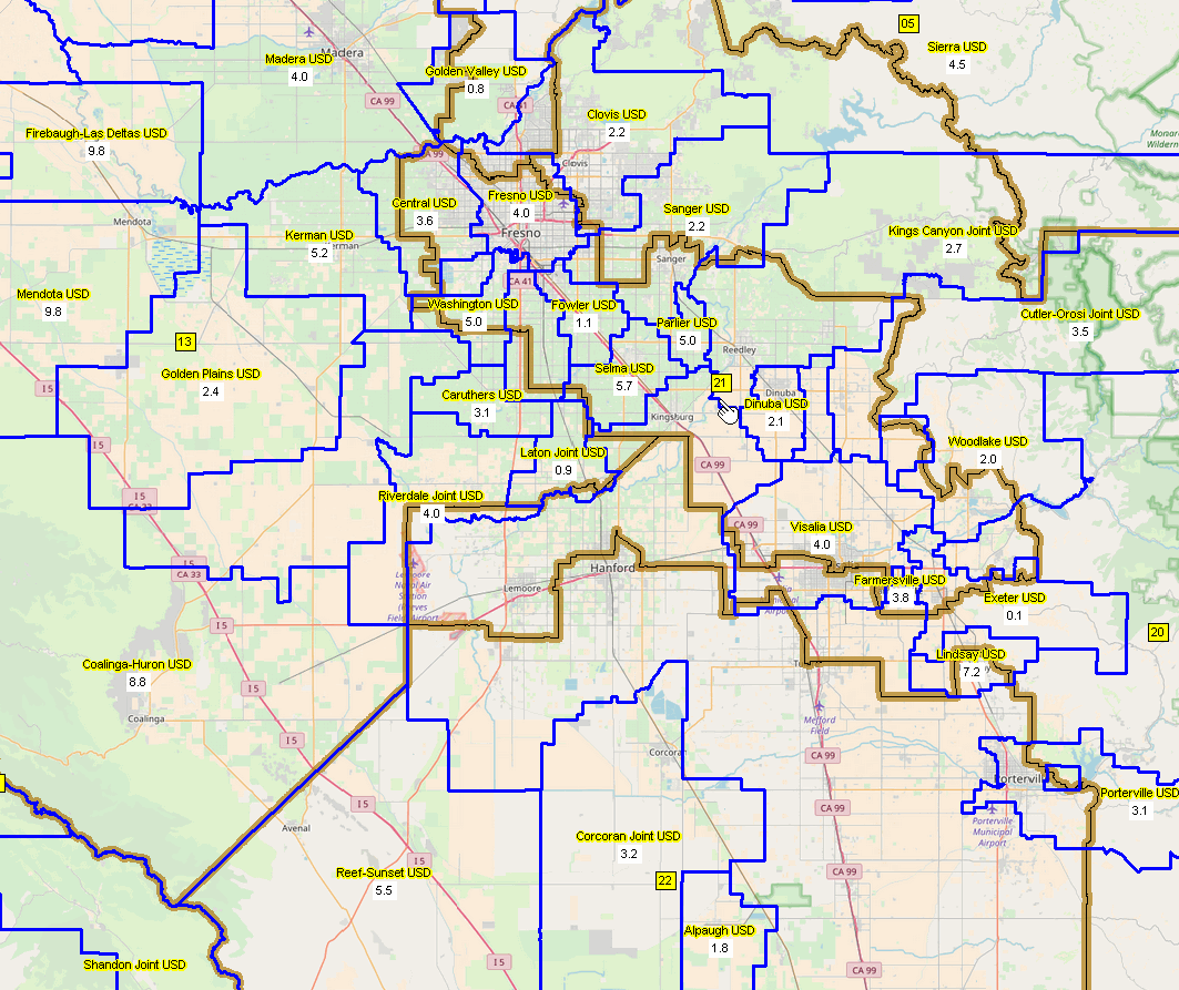 Similar Map Views for other areas Use VDA GIS tools to create similar maps for any area. Below are a few samples have the same settings as above. • Houston, TX • Orange - Los Angeles Counties. CA • Reno, NV - Tahoe area About the School District Special Tabulation .. goto top The first School District Special Tabulation (SDST) was developed for the U.S. National Center for Education Statistics (NCES) by the Census Bureau and Warren Glimpse, founder of ProximityOne, in the mid 1990s based on the 1990 Census. Part of the School District Data Book, it was integrated with the NCES Common Core of Data (schools and school districts), 1990 Census demgraphics and included the first national scope school district mapping. The SDST is updated annually -- a custom data collection of demographic, economic, social, and housing and economic data characteristics about school-age children and their families developed from the Census Bureau 5-year American Community Survey (ACS) data. The Children's tabulation defines a child as a person age 0 to 17 (at time of survey response) or a person age 18 or 19 who is not a high school graduate (based on the educational attainment response in the ACS questionnaire). The tabulations include demographic, social, economic, and housing characteristics iterated for six groups of school-age children. All iterations contain data for nation, states, and school districts. These iterations provide estimates for: 1. Total children in district (0-17 years, plus 18 - 19 who hav not graduated high school) 2. Grade-relevant children (grade relevant for the district) 3. Grade-relevant children enrolled in school 4. Grade-relevant children enrolled in public school 5. Grade-relevant children enrolled in other schooling 6. Grade-relevant children not enrolled in school Children's Demographics by School District .. goto top .. 11,383 school districts; see orientation to this table below table .. see related School District Main .. click column header to sort; click again to sort other direction. Table Usage Notes .. click ShowAll button between queries .. list of school district codes The above table is an interactive table. Use the buttons below the table to manage interactive operations. There is one row for each of the 11,383 school districts for which the SDST was tabulated. The leftmost columns provide name, location, codes of the district. Those columns are followed by 8 columns of SDST data items (data for selected children's universes). Those columns are followed by columns developed from the regular ACS 2021 5-year program. Within the table itself, navigate up and down with vertical and horizontal scroll bars. Use mouseover for expanded description of the subject matter header cells Click a header cell to sort one direction, click again to sort the other direction. Items in Table - Name -- School District Name - St -- State Postal Abbreviation - LEAID -- Local Education Agency ID (7 characters; the official Federal school district code) - St2 -- Census 2-Digit State Code (FIPS Code) - StCty -- Census 2-Digit State + 3-Digit County Code - Lo Grade -- Lowest Grade offered by district - Hi Grade -- Highest Grade offered by district - ESU -- Elementary, Secondary or Unified District Type Code From ACS 2021 5 yr School District Tabulation: - Total Children (0-17 years, plus 18 - 19 who have not graduated high school) - Grade Relevant Children (grade relevant for the district) - Grade Relevant Children Enrolled - Grade Relevant Children Enrolled in public schools - Grade Relevant Children Enrolled in other schooling - Grade Relevant Children Not Enrolled in school - Grade Relevant Children percent not enrolled From ACS 2021 5 yr regular published data: - Total population - Male population - Female population - White alone - Black alone - American Indian/Alaska Native alone - Asian alone - Native Hawaiian & Other Pacific Islander alone - Other race alone - Two or more races - Hispanic (of any race) - Population age 65 and over - Population in houseeholds - Households - Faminies - Total housing units - Owner occupied units - Renter occupied units - Vacant units - Median household income - Median family income - Median housing value - Median rent - Gini Index of Income Inequality Huntington Beach CA Area School Districts -- goto top Below is an illustration of the relationship among "stacked" districts; 4 elementary and 1 secondary. The button in the third row below the table (see above), marked "Group2 5 Areas (enter LEA ID)" has been populated with the LEA ID for all five Huntington Beach school areas. Here is the view of the interactive table after the "Group2 5 Areas (enter LEA ID)" button is clicked. The table shows 4 component elementary districts and 1 secondary district. Please note, the total populations for each of the 4 elementary districts sum to the same 321,439 as the secondary district. This population is the total population for all residents in the area, not just children. The population of total children in the school district is shown in the Total Children column. The number of total children in the 4 elementary districts sums to the same 65,208 figure as the secondary district. The figure of 65,208 exceeds the total listed in the Relevant Children (Rel Children) column, which totals 47,449. In other words, Relevant Children are the school age children, for grades offerred by that district, including 18 and 19 year olds who have not yet finished high school (for those districts offering grade 12). The 17,759 who are not included in the relevant children total have not yet reached school attending age for the purposes of the survey according to the parameters set by each district. The next four columns indicate the number of relevant children enrolled, those who are enrolled in public school, those who are enrolled in something other than public school, and those who are not enrolled. For each district, the sum of those enrolled in public schools, enrolled in other schools, and those not enrolled equals the total number of relevant children. Note: Relevant Children Not Enrolled is figure only found here. It is a not a figure that school districts or the National Center for Education Statistics reports. The view of the interactive table when Group2 button clicked. .. shows list of 4 component elementary districts comprising 1 secondary districts. 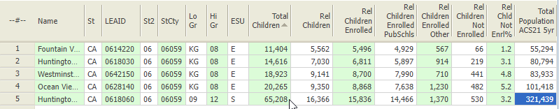 A view of 4 elementary districts (orange) comprising ground equivalent of 1 secondary district (green). .. profile of OceanView ESD shown at right. 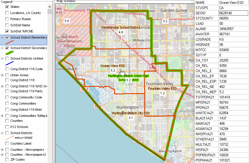 Grade Relevant Concept -- goto top A child is relevant to a school district if he/she lives within the territory of the district and his/her assigned grade is within the grade range for which a district is financially responsible. One of the unique features of school district geography is the potential for multiple districts to share the same physical territory but serve children of different grade levels. These overlapping boundaries typically occur in areas organized by Elementary and Secondary school districts. In cases where district boundaries overlap, this tabulation provides data iterations that offer both a physical count (total children within district boundaries) and a functional count (children within district boundaries for whom a district is financially responsible) to address areas where school districts do not serve all grade levels. When a child's residence is located within multiple districts, it assigns the child as relevant to a single school district (based on the child's assigned grade and the district that serves that grade level). This allows children to be tabulated as part of the total child population for each applicable district, but avoids duplicate tabulation when the intent is to identify children for whom a district is financially responsible. Non-district geographies (U.S. and States) are not affected by relevancy assignments. Relevant district assignments are dependent on a number of characteristics including: a child's grade level, the location of a child's residence relative to school district boundaries, and the grade span served by school districts in which a child resides. These elements are discussed below. Child's Grade Level Each child is assigned a grade level based on the ACS responses for grade enrolled or age of respondent and school attainment level if the child is not enrolled in school. Location of Child's Residence Relative to School District Boundary These ACS data assigns a child to a school district based on place of residence, not place of attendance. Children who attend school outside of the district in which they reside will not be counted in their attending district. This design will affect districts with students who participate in inter-district choice plans or with students attending private schools located outside the boundaries of the public school district. These data do not identify charter school systems unless they have geographic boundaries that are reported by a state. Similarly, these data do not provide information for individual school attendance areas, except by default in those cases where a school's attendance area is the same as the school district boundary. District Grade Span The Census Bureau updates boundaries for Elementary, Secondary, and Unified school districts, but does not require districts to fit a specific grade span for classification. It relies on school district grade spans reported by states to the National Center for Education Statistics (NCES) for the Common Core of Data (CCD) to adjust grade responses reported in the boundary update. The Common Core of Data identifies the administrative universe of public school districts in the U.S. and it identifies the lowest and highest grades served by each district. Grades may range from Pre-Kindergarten (PK) to Grade 12. The grade range of an Elementary district may be augmented down to the 1st grade and up no farther than 8th grade. The grade range of a Secondary district may be augmented up to 12th grade and down no farther than 7th grade. The grade range of a Unified district may be augmented up to 12th grade and down to 1st grade. In areas covered exclusively by Elementary districts (i.e., without Secondary districts) the grade range is augmented to accommodate the secondary age students. Most census blocks are part of a school district (or districts) that serves all grade levels. In some cases, all grade levels may not be covered for all blocks. For example, a block may be covered by an Elementary district (PK-6) and a Secondary district (8th-12th), but not be covered for the 7th grade. If a grade is not claimed by any district, it is assigned to the districts that are present in the following order: (1) Unified, (2) Elementary, (3) Secondary district. Conversely, if a grade is claimed by more than one district, the precedence is (1) Secondary, (2) Elementary, (3) Unified district. School district grade spans are not automatically augmented to include Pre-kindergarten or Kindergarten, however in a limited number of districts, the lower grade is adjusted to include Pre-Kindergarten or Kindergarten. These adjustments occur after direct contact and confirmation with local districts. ProximityOne User Group -- goto top Join the ProximityOne User Group to keep up-to-date with new developments relating to metros and component geography decision-making information resources. Receive updates and access to tools and resources available only to members. Use this form to join the User Group. Data Analytics Web Sessions Learn more about accessing and using demographic-economic data and related analytical tools. Join us in a Data Analytics Lab session. There is no fee for these one-hour Web sessions. Each informal session is focused on a specific topic. The open structure also provides for Q&A and discussion of application issues of interest to participants. Additional Information ProximityOne develops geodemographic-economic data and analytical tools and helps organizations knit together and use diverse data in a decision-making and analytical framework. We develop custom demographic/economic estimates and projections, develop geographic and geocoded address files, and assist with impact and geospatial analyses. Wide-ranging organizations use our tools (software, data, methodologies) to analyze their own data integrated with other data. Follow ProximityOne on Twitter at www.twitter.com/proximityone. Contact us (888-364-7656) with questions about data covered in this section or to discuss custom estimates, projections or analyses for your areas of interest. |
|
|