
|
|
|
Mapping America's Cities ... ready-to-use GIS tools and data to map and geospatially analyze cities
May 2020 .. The retreat in personal and household income will be historic and substantial. How long term? What cities of what size will be affected the most? We start to study patterns and trends as new data become available. Using GIS Resources to Examine America's Cities This section updates on May 11 with additional detail on resources that you can use to map and geospatially analyze America's 29,853 cities. Use the CV XE GIS software and associated ready-to-use Geographic Information System (GIS) project and data to examine your cities of interest in context of other geography. America's Largest Cities America's largest 630 cities accounted for 121,228,560, or 37.%, of the total U.S. population (327,167,434) in 2018 (details). All of these cities are in Metropolitan Statistical Areas (MSAs). With contiguous cities and places, these urban areas account for more than 80% of the U.S. population. These are cities with 65,000 population or more, shown as markers in the thematic patterns view below. This section is focused on using tools and data that you can use to map and geospatially analyze demographic/economic attributes of America's 29,853 cities/places. See more about cities/places and city/place 2010-2018 demographic trends. Top 25 Cities based on Median Household Income among America's Largest Cities
Patterns of Economic Prosperity: America's Largest Cities - cities with 2018 population 65,000+ shown as markers - markers show level of 2018 median household income - data used to develop this veiw were extracted using GeoFinder. - click map for larger view; expand browser to full screen for best quality view. 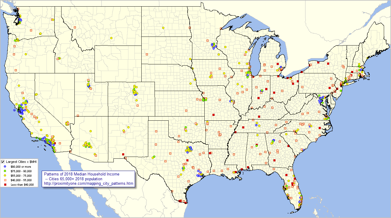 - view developed using ProximityOne CV XE GIS software and related GIS project. About America's Largest Cities America's largest cities is based on data from the 2018 American Community Survey 1-year estimates (ACS 2018). ACS 2018 data, by design, provides tabulations only for areas 65,000 population or more for all types of geographies covered. Support Using these Resources Learn more about accessing and using demographic-economic data and related analytical tools. Join us in a Data Analytics Lab session. There is no fee for these one-hour Web sessions. Each informal session is focused on a specific topic. The open structure also provides for Q&A and discussion of application issues of interest to participants. ProximityOne User Group Join the ProximityOne User Group to keep up-to-date with new developments relating to geographic-demographic-economic decision-making information resources. Receive updates and access to tools and resources available only to members. Use this form to join the User Group. Additional Information ProximityOne develops geographic-demographic-economic data and analytical tools and helps organizations knit together and use diverse data in a decision-making and analytical framework. We develop custom demographic/economic estimates and projections, develop geographic and geocoded address files, and assist with impact and geospatial analyses. Wide-ranging organizations use our tools (software, data, methodologies) to analyze their own data integrated with other data. Follow ProximityOne on Twitter at www.twitter.com/proximityone. Contact ProximityOne (888-364-7656) with questions about data covered in this section or to discuss custom estimates, projections or analyses for your areas of interest. |
|
|